crossbowftw3
-
Posts
1,394 -
Joined
-
Last visited
Content Type
Profiles
Blogs
Forums
American Weather
Media Demo
Store
Gallery
Everything posted by crossbowftw3
-
the potential result of this incredible anomaly:
-
Upstate/Eastern New York
crossbowftw3 replied to BuffaloWeather's topic in Upstate New York/Pennsylvania
Can we talk about how downright staggering of a storm next week be for almost everyone east of the continental divide if what some of these model inputs at least came partially true? -
The implications of what these model outputs are putting out is almost staggering. Understanding that they're still just outputs by this point this could be a seriously ugly storm for a large amount of the eastern 2/3 of CONUS if it were to play out verbatim
-
I think the overall semantics of the implications of what next week might bring is genuinely stunning all its own all across CONUS: A. A wide-reaching ice storm B. Significant snows, with potentially even incredibly favorable snow growth, in regions where you wouldn't have even expected it C. In conjunction with B, ridiculously cold temps so far south
-
Upstate/Eastern New York
crossbowftw3 replied to BuffaloWeather's topic in Upstate New York/Pennsylvania
Wouldn’t be shocked if tomorrow’s event gives someone 8” given the actually highly favorable ratios for basically the entire event...easily around and over 15:1 -
Additional 1-5" snow mostly North of I80 Tuesday Feb 9
crossbowftw3 replied to wdrag's topic in New York City Metro
Actually, upon further investigation snow ratios should be very favorable tomorrow here inland...talking probably right around 15:1 for a majority of the event. wouldn’t be shocked if someone maxes out between 8-9” in elevations where it stays the coldest longest, with most probably getting 3-6” -
The craziest part of all of this is that these all read off as minor-moderate events at their best...definitely showing how you don’t need big storm after big storm to keep piling on the snow
-
Additional 1-5" snow mostly North of I80 Tuesday Feb 9
crossbowftw3 replied to wdrag's topic in New York City Metro
Guess we get to do this again tomorrow @sferic probably another 3-4” on top everything we’ve seen in just the last 9 days -
2-7-21 Sunday 8-12 hour nor'easter snowstorm roughly 5A-5P
crossbowftw3 replied to wdrag's topic in New York City Metro
2" here as well, maybe pushing 3 -
2-7-21 Sunday 8-12 hour nor'easter snowstorm roughly 5A-5P
crossbowftw3 replied to wdrag's topic in New York City Metro
Puts my guess to shame, lol, admittedly I had forgotten all about Tuesday’s clipper shot and thought it was simply bad mapping -
2-7-21 Sunday 8-12 hour nor'easter snowstorm roughly 5A-5P
crossbowftw3 replied to wdrag's topic in New York City Metro
it looks like a bug with mapping -
2-7-21 Sunday 8-12 hour nor'easter snowstorm roughly 5A-5P
crossbowftw3 replied to wdrag's topic in New York City Metro
Rather surprisingly, WWA for 3-5 in Sullivan now -
2-7-21 Sunday 8-12 hour nor'easter snowstorm roughly 5A-5P
crossbowftw3 replied to wdrag's topic in New York City Metro
Gusts 20-30 were in the forecast for today so yes -
2-7-21 Sunday 8-12 hour nor'easter snowstorm roughly 5A-5P
crossbowftw3 replied to wdrag's topic in New York City Metro
With the disclaimer that if the heavier shield comes further in we can get into 3-6* -
2-7-21 Sunday 8-12 hour nor'easter snowstorm roughly 5A-5P
crossbowftw3 replied to wdrag's topic in New York City Metro
Just the NAM really -
2-7-21 Sunday 8-12 hour nor'easter snowstorm roughly 5A-5P
crossbowftw3 replied to wdrag's topic in New York City Metro
If the precip shield can really reach this far N/W, yes, otherwise the 1-3 makes more sense -
2-7-21 Sunday 8-12 hour nor'easter snowstorm roughly 5A-5P
crossbowftw3 replied to wdrag's topic in New York City Metro
3-6 with iso 8 -
Upstate/Eastern New York
crossbowftw3 replied to BuffaloWeather's topic in Upstate New York/Pennsylvania
I'd expect OKX's WWAs to be converted to warnings and then we get some WWAs issued up here for 3-6" -
2-7-21 Sunday 8-12 hour nor'easter snowstorm roughly 5A-5P
crossbowftw3 replied to wdrag's topic in New York City Metro
I would anticipate BGM issuing advisories for Sullivan, Delaware and into Wayne/Pike PA possibly now -
2-7-21 Sunday 8-12 hour nor'easter snowstorm roughly 5A-5P
crossbowftw3 replied to wdrag's topic in New York City Metro
Looks like low-end advisory snows here. Don't mind it at all, but I want to see one more tick to get us to 3-6" -
2-7-21 Sunday 8-12 hour nor'easter snowstorm roughly 5A-5P
crossbowftw3 replied to wdrag's topic in New York City Metro
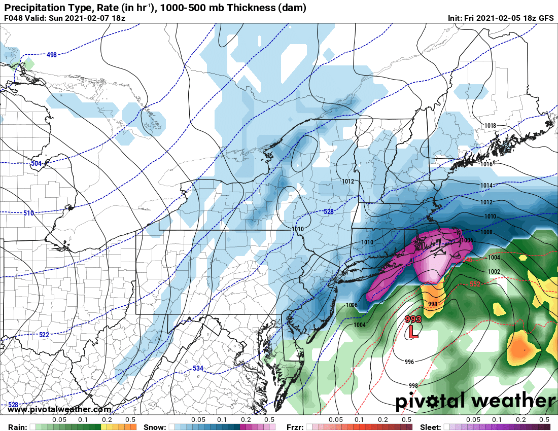
What is exactly going on here with the GFS....?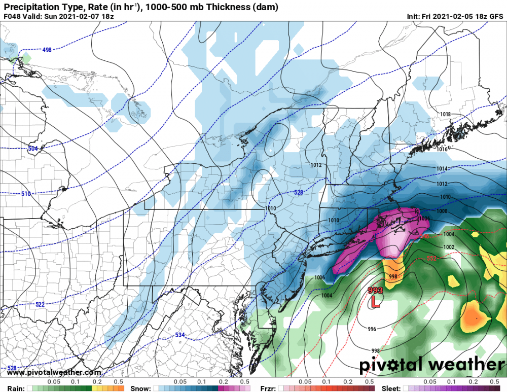
-
2-7-21 Sunday 8-12 hour nor'easter snowstorm roughly 5A-5P
crossbowftw3 replied to wdrag's topic in New York City Metro
Marginal warning at that, it would still be just as possible to issue a high end WWA for 4-7. Don't like the idea overall for anything over that this far inland -
2-7-21 Sunday 8-12 hour nor'easter snowstorm roughly 5A-5P
crossbowftw3 replied to wdrag's topic in New York City Metro
that's still close to upper bound WWA for inland areas -
2-7-21 Sunday 8-12 hour nor'easter snowstorm roughly 5A-5P
crossbowftw3 replied to wdrag's topic in New York City Metro
3-6 still seems good -
2-7-21 Sunday 8-12 hour nor'easter snowstorm roughly 5A-5P
crossbowftw3 replied to wdrag's topic in New York City Metro
I know not many here would care about NASCAR but the original President’s Day blizzard did something very similar and many call it the reason it exists as it does now