crossbowftw3
-
Posts
1,394 -
Joined
-
Last visited
Content Type
Profiles
Blogs
Forums
American Weather
Media Demo
Store
Gallery
Everything posted by crossbowftw3
-
URGENT - WINTER WEATHER MESSAGE National Weather Service Binghamton NY 422 PM EST Sat Jan 2 2021 NYZ062-032130- /O.EXA.KBGM.WW.Y.0001.210103T1600Z-210104T0400Z/ Sullivan- Including the city of Monticello 422 PM EST Sat Jan 2 2021 ...WINTER WEATHER ADVISORY IN EFFECT FROM 11 AM TO 11 PM EST SUNDAY... * WHAT...Wet snow expected. Total snow accumulations of 2 to 5 inches. * WHERE...Sullivan county. * WHEN...Snow will develop late in the morning Sunday, peak in intensity in the afternoon and taper off Sunday evening. * IMPACTS...Plan on slippery road conditions.
-
Pretty reasonable guess, perhaps hold some 6 or more to anything even higher than 1500
-
Obs and nowcast Friday afternoon-night 18z NY Day 2021- 12z/2
crossbowftw3 replied to wdrag's topic in New York City Metro
The melting is well underway now. It's a beautiful sound. -
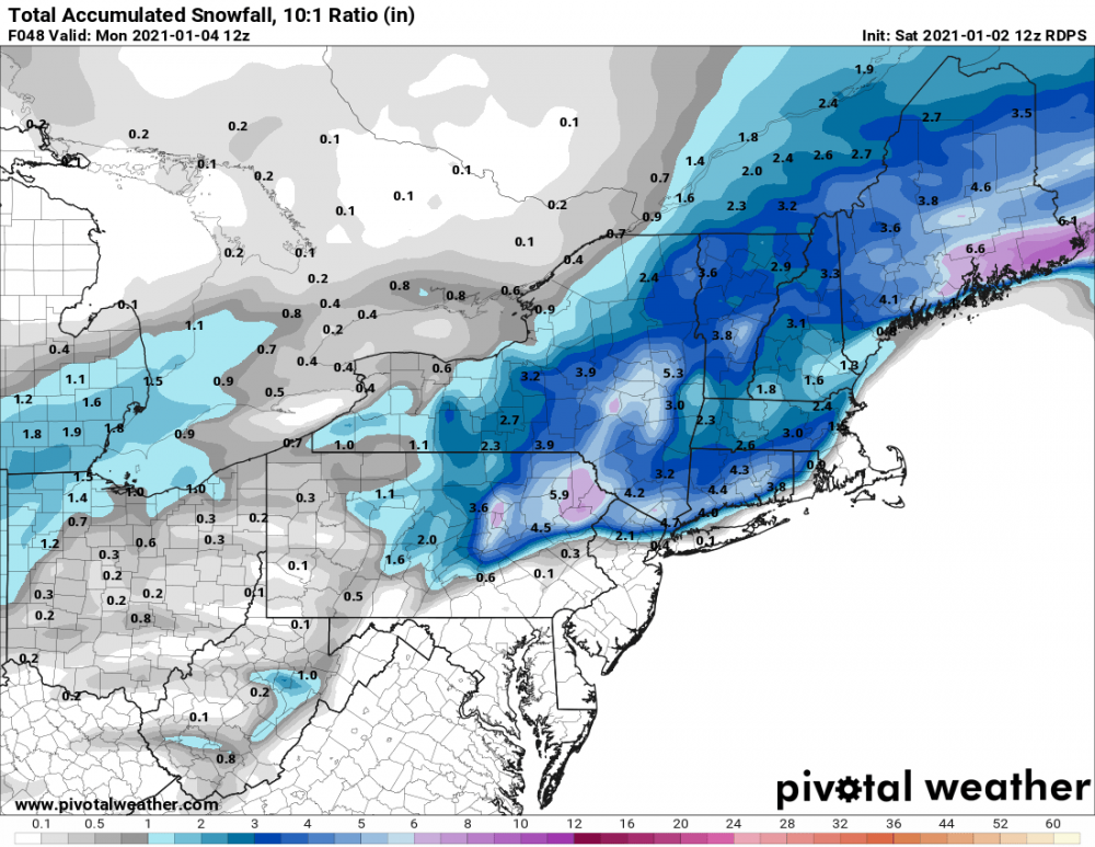
I'd favor 1250-1500+' areas for the 8 inch totals and a general 2-6 everywhere else. Ratios will probably not be the perfect 10:1 but still pretty close regardless.
-
Should also say if there are to be any 8"+ totals it's definitely eastern New England as the low gets going
-
3-6 is still a solid bet, maybe swing up to 4-8 depending. Going to be a nice event not unlike last January 18 (I think?)
-
Upstate/Eastern New York
crossbowftw3 replied to BuffaloWeather's topic in Upstate New York/Pennsylvania
Listening to the ice melt away is somehow one of the most oddly satisfying things one can do for some reason. 37/35 at my place as of now We have to then replace this with at least 2-4" of snow tomorrow winter can be fascinating yet highly confounding at the same time -
Got some snow maps for that or?
-
Obs and nowcast Friday afternoon-night 18z NY Day 2021- 12z/2
crossbowftw3 replied to wdrag's topic in New York City Metro
By my eye testing we got about .2” ice here as well. Roads look just wet but trees are obviously glazed over. 35/34 now with some melting occurring. Hopefully most of this melts before tomorrow’s snow- 58 replies
-
- 1
-

-
- freezing rain
- sleet
- (and 2 more)
-
Obs and nowcast Friday afternoon-night 18z NY Day 2021- 12z/2
crossbowftw3 replied to wdrag's topic in New York City Metro
Addendum: sleet is back now.- 58 replies
-
- 1
-

-
- freezing rain
- sleet
- (and 2 more)
-
Obs and nowcast Friday afternoon-night 18z NY Day 2021- 12z/2
crossbowftw3 replied to wdrag's topic in New York City Metro
It was pinging away for a time now it sounds like very light ZR with temperatures still hanging right around freezing.- 58 replies
-
- 1
-
-
- freezing rain
- sleet
- (and 2 more)
-
Currently also guessing 2-4/3-6 here in Sullivan. At my elevation rain mixing in would probably cap things a bit, but we’ll see what happens over the next day
-
Obs and nowcast Friday afternoon-night 18z NY Day 2021- 12z/2
crossbowftw3 replied to wdrag's topic in New York City Metro
Temperatures hanging only slightly above freezing to begin at 33/24. Looking for about a 6-10 hour frozen period before I get back above freezing and change to rain. looking like a haves and have nots again WRT ice at my lower elevation (750 or so) versus most elsewhere in the county...maybe we see .1 here versus most elsewhere being closer to .25.- 58 replies
-
- 1
-
-
- freezing rain
- sleet
- (and 2 more)
-
What are you seeing from the HRDPS?
-
Upstate/Eastern New York
crossbowftw3 replied to BuffaloWeather's topic in Upstate New York/Pennsylvania
Advisories populating- general 1-3 and ice of .1-.25, even .3 possible. -
And sure enough... URGENT - WINTER WEATHER MESSAGE National Weather Service Binghamton NY 226 PM EST Thu Dec 31 2020 NYZ062-PAZ040-048-072-011930- /O.NEW.KBGM.WW.Y.0023.210101T2000Z-210102T1200Z/ Sullivan-Northern Wayne-Pike-Southern Wayne- Including the cities of Monticello, Damascus, Equinunk, Milford, and Honesdale 226 PM EST Thu Dec 31 2020 ...WINTER WEATHER ADVISORY IN EFFECT FROM 3 PM FRIDAY TO 7 AM EST SATURDAY... * WHAT...Mixed precipitation expected. Total snow accumulations of up to one inch and ice accumulations of one tenth to three tenths of an inch. * WHERE...In Pennsylvania, Northern Wayne, Pike and Southern Wayne counties. In New York, Sullivan county. * WHEN...A mix of snow and sleet will develop by early evening New Year`s Day. The precipitation will change to freezing rain in the evening and last into the overnight and early morning of Saturday. The freezing rain will taper off to a few rain showers by sunrise Saturday as temperatures rise above freezing. * IMPACTS...Travel could be nearly impossible. The hazardous conditions could impact the evening commute New Year`s Day.
-
The SPC map does show the elevations well- but probably overdone anyway as you say. But I still wouldn’t be shocked if some instances of accretions .3-.4 happen above 1500’.
-
January 2021 General Discussions & Observations Thread
crossbowftw3 replied to Stormlover74's topic in New York City Metro
Gotta wade through the mud to find the goldmine. Tomorrow’s event will come and go, and Sunday-Monday hinges on a marginal airmass, but I can’t wait to see what happens mid-month. Up here we made it to roughly 1/3 of what we had last year from the 16th/17th (36 inches which was roughly 25-30 below average) and here’s to hoping we can cover our totals from last year (if at all possible) by then. -
Advisories will probably get issued later on today, and maybe some WSWs for CTP? (Only really because their threshold for WSWs is .25 of ice). Either way Sunday-Monday is of more interest at this point
-
December 2020 General Discussions & Observations Thread
crossbowftw3 replied to bluewave's topic in New York City Metro
It stayed rain all night here -
The trends on the NAM are a bit surprising but again we can be thankful this doesn’t have much staying power and/or much precipitation to go with it...otherwise problems would certainly begin to arise. I’ll definitely be on the lookout for HREFs tomorrow but figure I’ll stay right where I am with .1-.3 with maybe a high end of .5 in typical elevations where the cold takes longest to clear out. Pretty typical messy little system and to me it never changed from being that.
-
Dec (Edit: Jan1/..2 ) multi-faceted ptype mess potential...
crossbowftw3 replied to Typhoon Tip's topic in New England
Is it time to order up a MLK blizzard?