crossbowftw3
-
Posts
1,394 -
Joined
-
Last visited
Content Type
Profiles
Blogs
Forums
American Weather
Media Demo
Store
Gallery
Everything posted by crossbowftw3
-
Yeah I don’t expect much more than maybe 4-5” to be OTG by tomorrow afternoon. Tomorrow night is the real show here. I’m planning to clear whatever is on the ground at or around noon tomorrow so the job on Tuesday morning can be at least somewhat easier.
-
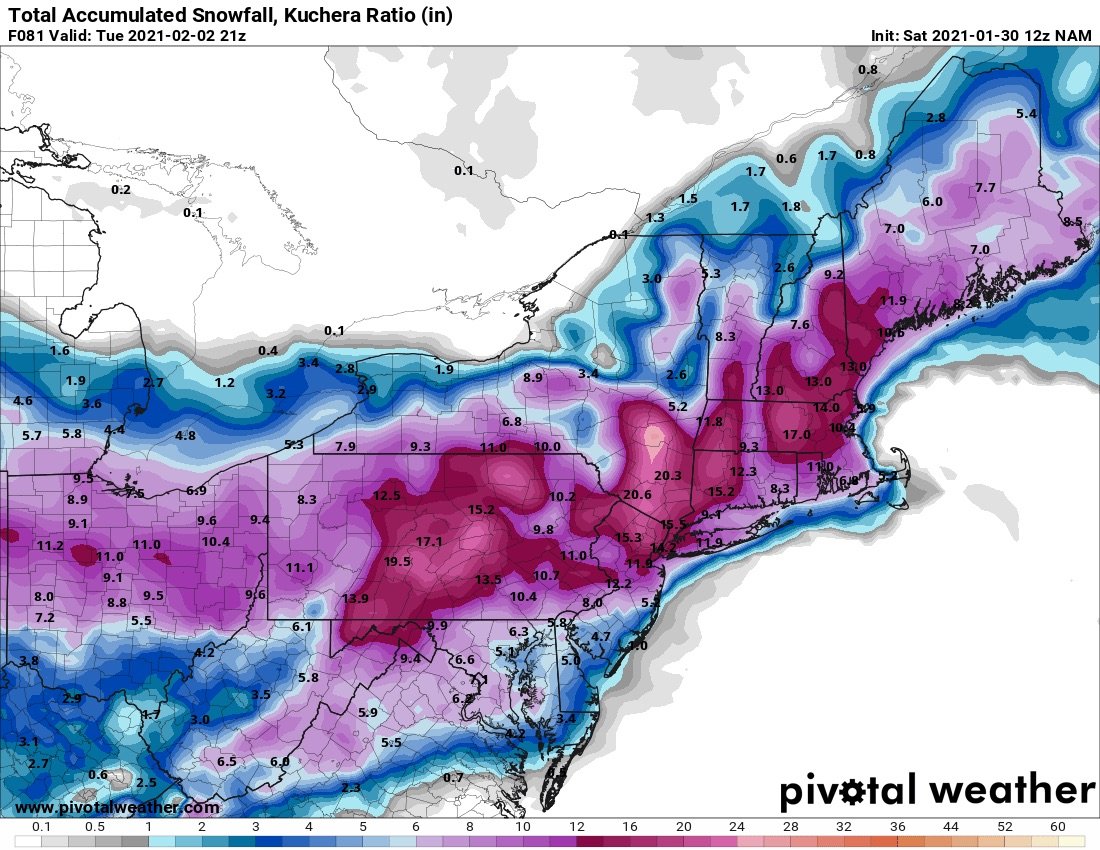
Ratios should be more favorable here than closer to NYC/LI. All depends on if banding pokes in
-
NAM giving me 6-10 this run? And it still keeps NYC/LI in the Jack zone? I’ll gladly take it for myself and giving the snow-starved here something special
-
Walt, Any idea on ratios for inland folks? I'd think similar in stature to 12/17--guessing 10-13/14:1 again with temps not getting much above 27-29 during daytime Monday and falling back between 23-26
-
I would genuinely be annoyed if that happened.
-
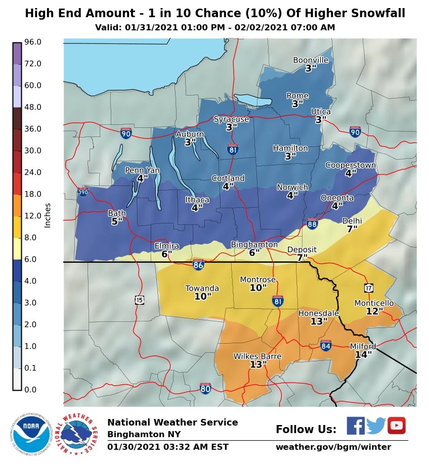
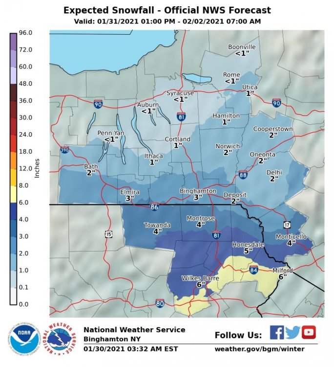
Probably BGM's first guess of 6-12 makes sense, we can still cash in on this but probably not nearly as much as closer to NYC
-
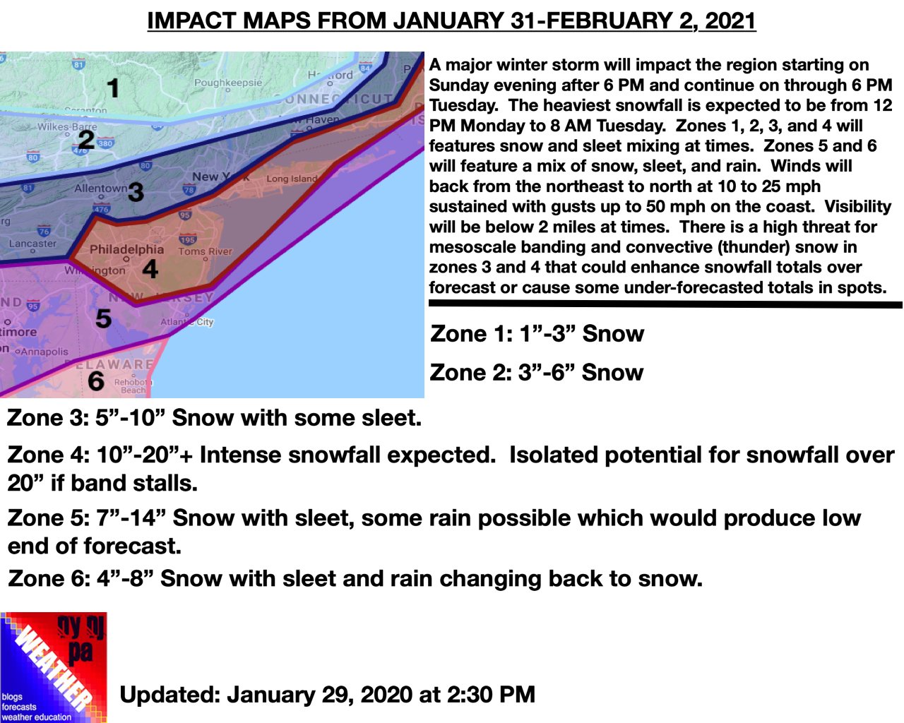
BGM's WSW-acknowledges the longer duration to get to these totals+after this still going into how much uncertainty remains. ...WINTER STORM WATCH IN EFFECT FROM SUNDAY AFTERNOON THROUGH TUESDAY AFTERNOON... * WHAT...Heavy snow possible. Total snow accumulations of 6 to 12 inches possible. * WHERE...In Pennsylvania, Bradford, Susquehanna, Northern Wayne, Lackawanna, Pike and Southern Wayne counties. In New York, Chemung, Tioga, Broome, Delaware and Sullivan counties. * WHEN...From Sunday afternoon through early Tuesday afternoon. * IMPACTS...Travel could be very difficult. The hazardous conditions could impact the morning or evening commutes. * ADDITIONAL DETAILS...This will be a long duration event. A few to several inches of lighter snow are possible Sunday evening through Monday. Then for Monday night into Tuesday morning, additional snow is expected which may be heavy at times, along with areas of blowing snow.
-
They did but this situation feels so much more volatile for us North of 84. We were always guaranteed a good event then, but this time much less so. Effectively speaking the margin of error between 1" and over a foot is very thin. I've forgotten how it feels to be in this situation
-
Very unusual situation here. WSWatch hoisted but this isn’t guaranteed in the slightest. We have to keep watching this and won’t hone in on one common solution until tomorrow.
-
That’s a legit death band if I’ve ever seen one. Surely >3” an hour would be going on in that
-
How much closer do we see these goalposts narrow today do you think? I’m still discounting bigger totals this far north in Sullivan but as I’ve said all morning marginal warning level snows seems to be growing ever plausible here.
-
The end result. Would be a tease to go from 7-8” to over 20 in the span of a 30-45 minute drive
-
Highly favorable ratios as well....looks like over 12:1 edit: maybe even well over
-
Agreed, everyone north of 84’s prospects look a bit better today (I’d adjust my call to 5-8 if I had to) but the bullseye of the higher totals are still definitely where they have been for the last day or so
-
No reason to think it wouldn’t be adjusted. This is normal waffling and I would personally expect a shift back south enough to narrow the goalposts of the jackpot zone
-
BGM high end map looks oddly similar to the first map they posted for 12/16-17...versus the expected. Both still probably make equal amounts of sense as of this point.

-
Which is why I don’t intend to just jump on what happened overnight, I would still expect things to level off with today’s runs to end up with that 95-84 jackpot but I can now reasonably say low-end warning amounts at least to where I’m at now
- 2,426 replies
-
- 3
-

-
- heavy snow
- ice pellets
- (and 3 more)
-
Still need more than a few extra ticks to get much more than 3-6/4-8 north of 84, looking like somewhere between 84-95 and points SW of there should be the definites for 8+.
-
Can't have one to have the other but I'd gladly sit this one out to give LI an all snow event
- 2,426 replies
-
- 3
-
-
- heavy snow
- ice pellets
- (and 3 more)
-
Upstate/Eastern New York
crossbowftw3 replied to BuffaloWeather's topic in Upstate New York/Pennsylvania
Shades of January 2016 all over again -
2016 all over again. My sister and her fiancé live in Peekskill and they’re going to be my personal measuring stick for how intense the gradient ends up being between their house and mine in Sullivan.
-
Upstate/Eastern New York
crossbowftw3 replied to BuffaloWeather's topic in Upstate New York/Pennsylvania
It can come back but it may not be enough to do much more than marginal warning. 6-8 is a probable upper bound -
Upstate/Eastern New York
crossbowftw3 replied to BuffaloWeather's topic in Upstate New York/Pennsylvania
Definitely teetering and can go either way. I’ll go for a reasonable call and say enough ticks happen for some of BGM’s WFO to get 3-6