crossbowftw3
-
Posts
1,394 -
Joined
-
Last visited
Content Type
Profiles
Blogs
Forums
American Weather
Media Demo
Store
Gallery
Everything posted by crossbowftw3
-
Snow-ice-rain for the NYC forum 7PM Mon 1/25-6AM Wednesday 1/27
crossbowftw3 replied to wdrag's topic in New York City Metro
We may not need them here given that this would be over a longer duration though -
January 2021 General Discussions & Observations Thread
crossbowftw3 replied to Stormlover74's topic in New York City Metro
We haven’t seen any such sustained 60s-70s during winter since the 2017-18 period. If that happens I wonder what may then occur over the rest of the winter. -
Snow-ice-rain for the NYC forum 7PM Mon 1/25-6AM Wednesday 1/27
crossbowftw3 replied to wdrag's topic in New York City Metro
Walt’s 4-7 guess for my area/extreme NEPA/NNJ would be a good high end -
Snow-ice-rain for the NYC forum 7PM Mon 1/25-6AM Wednesday 1/27
crossbowftw3 replied to wdrag's topic in New York City Metro
I’m gonna hang on to 2-4 for me in the Catskills and that’d be solid. Anything significantly more is pointing more or less at CPA and points west it would seem by this point. -
Snow-ice-rain for the NYC forum 7PM Mon 1/25-6AM Wednesday 1/27
crossbowftw3 replied to wdrag's topic in New York City Metro
General malaise that only the genius possess and the insane lament? We’re definitely teetering on the edge of a light event or something more moderate with some warning level totals, also with some perhaps making it into the city proper. I’d think some more eyes would be paying attention here. -
Snow-ice-rain for the NYC forum 7PM Mon 1/25-6AM Wednesday 1/27
crossbowftw3 replied to wdrag's topic in New York City Metro
and stays because we're entering the coldest stretch of this winter after that. -
Snow-ice-rain for the NYC forum 7PM Mon 1/25-6AM Wednesday 1/27
crossbowftw3 replied to wdrag's topic in New York City Metro
Some genuinely cold nights ahead after this frame -
Snow-ice-rain for the NYC forum 7PM Mon 1/25-6AM Wednesday 1/27
crossbowftw3 replied to wdrag's topic in New York City Metro
Looks like we're teetering on the edge here in Sullivan. If it comes to only getting 1-3 that'll still be fine but I need some more north trends to get into something good. -
Upstate/Eastern New York
crossbowftw3 replied to BuffaloWeather's topic in Upstate New York/Pennsylvania
Looks like I got a slushy coating, which is now beginning to be washed away as we’ve flipped back to showers. -
January 2021 General Discussions & Observations Thread
crossbowftw3 replied to Stormlover74's topic in New York City Metro
Elevations still best, I can’t count on more than a few inches. -
Upstate/Eastern New York
crossbowftw3 replied to BuffaloWeather's topic in Upstate New York/Pennsylvania
And the split between synoptic and LES events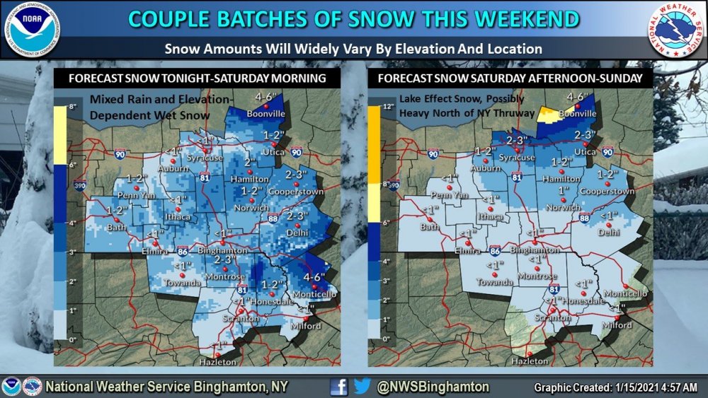
-
Upstate/Eastern New York
crossbowftw3 replied to BuffaloWeather's topic in Upstate New York/Pennsylvania
New BGM map. Once again 15-25 minutes is pretty much the difference from next to nothing to >=3-4”.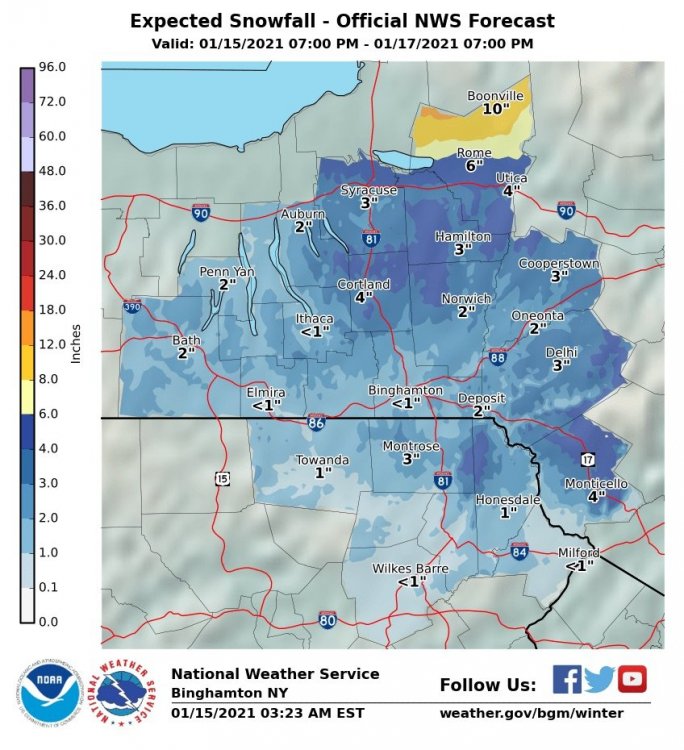
-
Upstate/Eastern New York
crossbowftw3 replied to BuffaloWeather's topic in Upstate New York/Pennsylvania
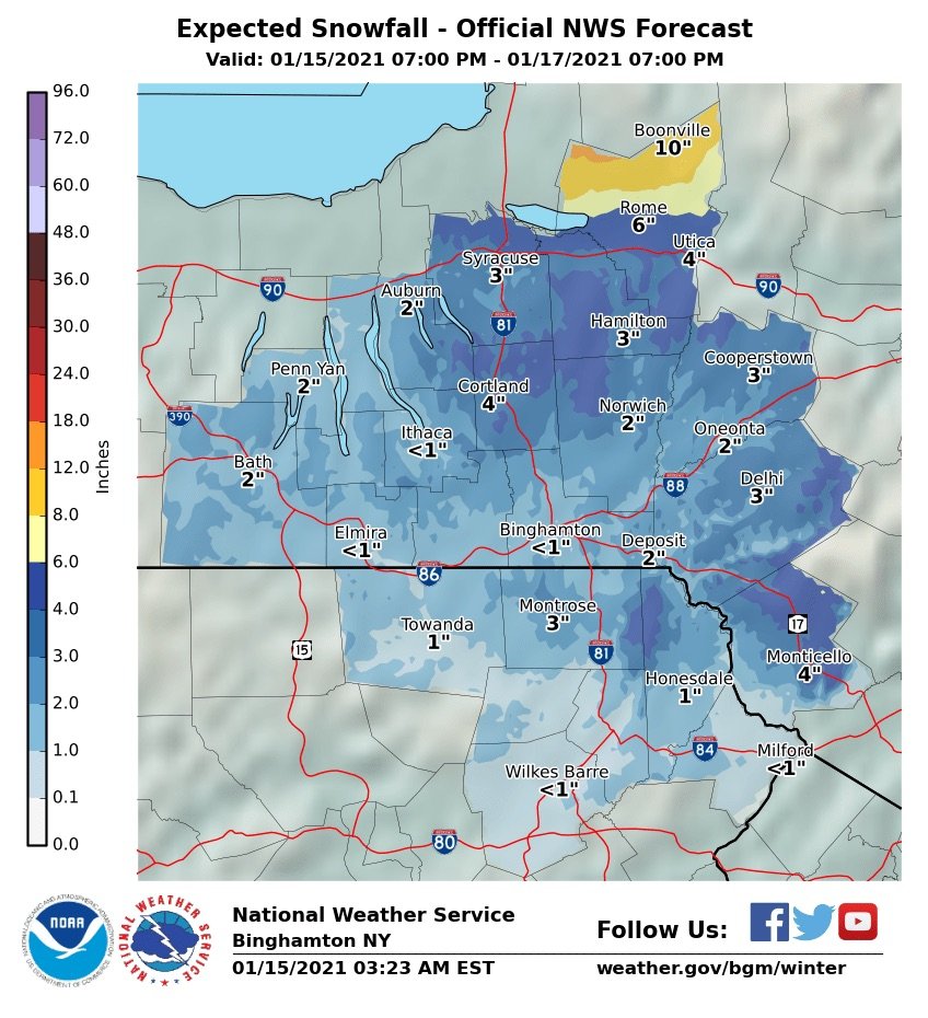
BGM first call...looks largely reasonable. @sferic you could get 3-4” from this. Not looking for more than 1-2” where I am in Narrowsburg.
-
Upstate/Eastern New York
crossbowftw3 replied to BuffaloWeather's topic in Upstate New York/Pennsylvania
Whatever the NAM 3k is on, can I have some? Tossed. -
Upstate/Eastern New York
crossbowftw3 replied to BuffaloWeather's topic in Upstate New York/Pennsylvania
Interesting map. Assuming this combines the elements of today, tomorrow night, and then the LES. At my lower elevation in Sullivan I’m guessing the under, but it’ll still be an inch or so. Elevation driven event regardless.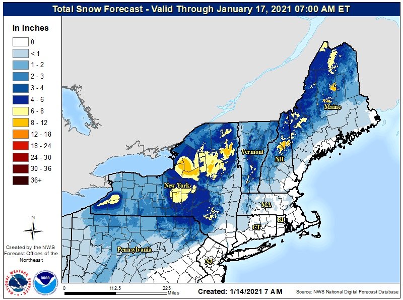
-
January 2021 General Discussions & Observations Thread
crossbowftw3 replied to Stormlover74's topic in New York City Metro
Pretty interesting map. Seems a bit overcooked but elevations can probably cash in 3-5” before the LE train begins.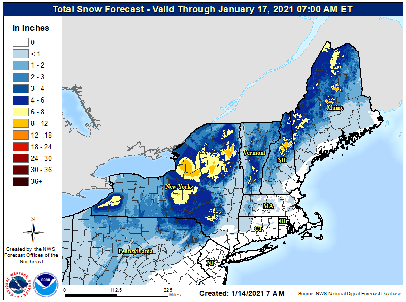
-
January 2021 General Discussions & Observations Thread
crossbowftw3 replied to Stormlover74's topic in New York City Metro
Could sneak in an inch or two up here in Sullivan on Saturday. Not overly counting on it but it’d be nice before the lake response kicks up. -
January 2021 General Discussions & Observations Thread
crossbowftw3 replied to Stormlover74's topic in New York City Metro
figure I’ll toss this out once again. The theme of rather scary analogs for tornado season continues. While obviously not implicating any one event this year matches the ferocity of those, the potential very much exists. It should also be noted that in some of these examples a TC would then eventually ride up the East Coast, most notably (and recently) Irene. -
January 2021 General Discussions & Observations Thread
crossbowftw3 replied to Stormlover74's topic in New York City Metro
Well, while this weekend’s threat is pretty much gone now; next week is starting to look pretty interesting at this point. -
Obs and nowcast Sun 9A Jan 3 - 6A Mon Jan 4 2021
crossbowftw3 replied to wdrag's topic in New York City Metro
Watching the trees begin to self-clean themselves. It’s actually quite fascinating to see. -
Obs and nowcast Sun 9A Jan 3 - 6A Mon Jan 4 2021
crossbowftw3 replied to wdrag's topic in New York City Metro
Yep, finished with 4” on the dot here. -
Obs and nowcast Sun 9A Jan 3 - 6A Mon Jan 4 2021
crossbowftw3 replied to wdrag's topic in New York City Metro
Been lightly snowing for hours while areas west of me are getting the banding. Doesn’t look like more than 3-4” while 1500’ elevation areas are getting over 10” -
Obs and nowcast Sun 9A Jan 3 - 6A Mon Jan 4 2021
crossbowftw3 replied to wdrag's topic in New York City Metro
And we are now underway with more moderately heavy snow here in Sullivan. 32/30 -
Obs and nowcast Sun 9A Jan 3 - 6A Mon Jan 4 2021
crossbowftw3 replied to wdrag's topic in New York City Metro
With what I got OTG from this morning the forecast should easily be met, curious though about if any banding can form to help bust totals high...but probably not by much given the quick movement of the Storm overall. BGM seems to think a 5-6 hour window of banding could happen -
From eye testing easily around .5-.75 is currently on the ground after the initial burst, should help to easily meet the forecast. Curious to see if any banding forms to help bust some of these forecasted amounts high, but Storm still moving too quickly to go anything more than 6-7”