crossbowftw3
-
Posts
1,394 -
Joined
-
Last visited
Content Type
Profiles
Blogs
Forums
American Weather
Media Demo
Store
Gallery
Everything posted by crossbowftw3
-
Look for him to say “massive, slow-moving ocean low” among other things
-
See here:
-
Your assumption would be correct. For the rest of us we will probably have some in-air flakes, maybe even some slushy accumulations at elevation, but it’s SNE’s show at this point and not ours.
-
Seeing the sights around Texas and Colorado.
-
NAM still looks nutty for CT/MA folks. For most of the rest of us this ship is growing ever closer to have sailed and that we’ll just have a wet, raw day and night. October 2011 was probably more rare purely because of how widespread it was able to be. Realistically, this would only be meaningful/significant at higher New England elevations.
-
still entirely plausible to see this happen, but might be fleeting a bit after today's runs now.
-
the moment I saw that NAM run I fully committed to the idea that the Euro has the right idea with this whole thing, and that the Berkshires are set up to get pummeled on this one. Not like many of us will see the flakes fly anyway, even for those of us N&W of the city who could squeak in 1-3" if we get absolutely lucky. N&E of the City is where one needs to be here.
-
We’ll make sure to lend some of our power company people over to you guys
-
Upstate/Eastern New York
crossbowftw3 replied to BuffaloWeather's topic in Upstate New York/Pennsylvania
Slip sliding away Hudson River East is really gonna end up as the place to be
-
Absolute whopper for NE starting to really cut it close for those of us in the Catskills however

-
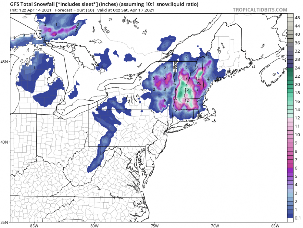
One whopper of a snow map. Starting to look like everyone east of the river is in for one heckuva ride
-
I think some on Long Island will VERY MUCH like the 18z NAM
-
8” of snow onto Long Island and even NYC proper gets to see some snow, really starting to cut it close for anything meaningful for all of us in the Catskills and Poconos.
-
Knowing where you are you might be really close to some big totals if some of the 12z runs are to be taken at face value. It’s gonna come down to a nowcast for you I would say.
-
In this case; yes.
-
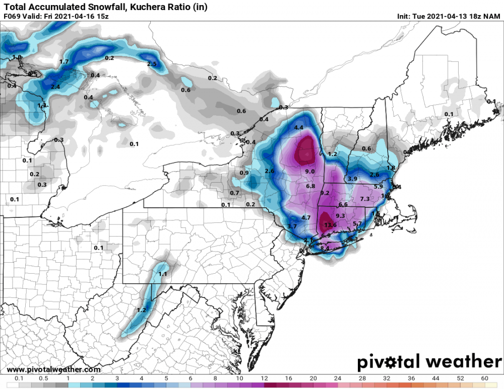
Midday GFS remains relatively consistent, definite consensus on where the biggest axis of snow is: for the rest of us to see anything, the devil remains in the details
-
Midday GFS stays relatively consistent, way better focus on the Berks now
-
Upstate/Eastern New York
crossbowftw3 replied to BuffaloWeather's topic in Upstate New York/Pennsylvania
The Berkshires are quickly evolving into the place to be to really get the goods on this one -
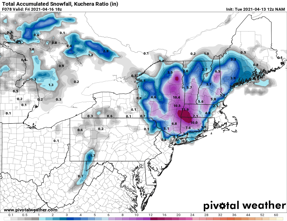
From purely examining what has emerged today I think we should still be fine to see 2-4/3-6 with up to 8 or even more at elevations. The Berkshires are emerging as the potential crush zone in this
-
I’d do anything to be at a ski resort in the Berkshires right now.
-
In that case I’d roll with an idea of seeing 2-4/3-6” for some of us even this far west and into lower elevations with definite room for up to a foot in the typical elevations. In general, still have to favor elevations
-
That’s what I’ve been wondering all along. Those of us in this sub forum who aren’t elevated seemingly just miss everything. Elevated areas of SNE might be in position to get smacked here
-
What are your feelings about areas further west of the river, specifically into the lower elevations of the Catskills/Poconos; are we probably out of the game save for higher elevations? Beginning to think it’ll be much more elevation driven here than anywhere else
-
Upstate/Eastern New York
crossbowftw3 replied to BuffaloWeather's topic in Upstate New York/Pennsylvania
12z NAM tries to re-up the ante some, but I get the feeling most of us miss, even folks like me downstate who might be just a tad too far west and get fringed:
-
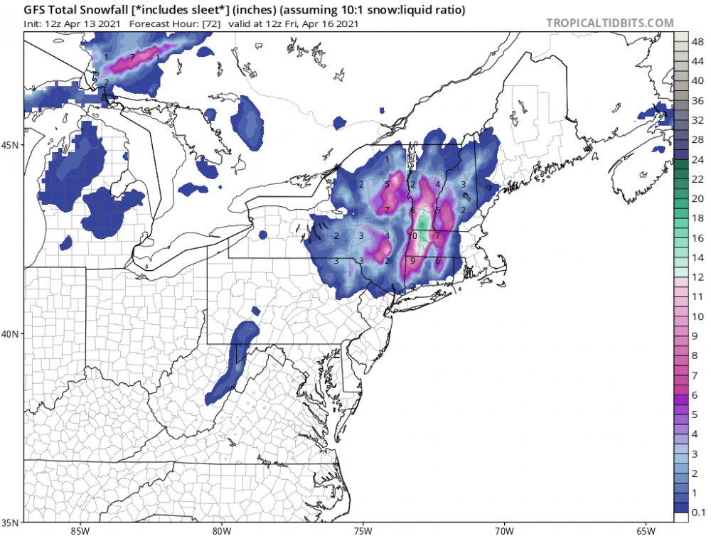
12z NAM attempts to re-up the ante, but getting the feeling us far N&W folks at lower elevations might be too far west/get fringed: