

Kmlwx
-
Posts
13,431 -
Joined
-
Last visited
Content Type
Profiles
Blogs
Forums
American Weather
Media Demo
Store
Gallery
Everything posted by Kmlwx
-
69 on the dot in Colesville! For June 9th that is amazing.
-
No stench here and visibility is much better than yesterday morning. Nice morning out there for the most part! Low of 49 here.
-
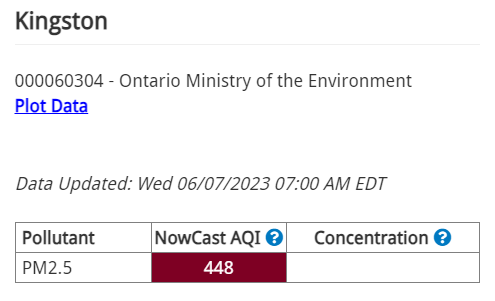
I was able to see sunspots using my S23 Ultra's camera. I can DEFINITELY "feel" the poor AQI now. Noticeable cough this morning. The odor isn't really like that nice bonfire odor either - it almost smells like fabric burning.
-

2023 Mid-Atlantic Severe Wx Thread (General Discussion)
Kmlwx replied to Kmlwx's topic in Mid Atlantic
This truly is quite the boring stretch locally in terms of severe. It will break at some point...- 2,785 replies
-
- 1
-

-
- severe
- thunderstorms
- (and 3 more)
-
Up in Canada in the big plume coming down now -
-
Bad enough at the surface here that it looks like fog. Yesterday's HRRR runs seemed to indicate a BIG plume coming down later today into tonight potentially making it even worse.
-
HRRR seems to suggest smoke will be even worse tomorrow afternoon/evening as another batch of smoke gets pushed down into our area.
-
2023 Mid-Atlantic Severe Wx Thread (General Discussion)
Kmlwx replied to Kmlwx's topic in Mid Atlantic
Quoting you over here - certainly a nice look! 9 days away, though! -
Hit 90 and now 89.2 Dewpoint over 60 as well - so not intolerable...but fitting for the first few days of met summer.
-
2023 Mid-Atlantic Severe Wx Thread (General Discussion)
Kmlwx replied to Kmlwx's topic in Mid Atlantic
Well we all anecdotally know about the "rubber band" effect. Long periods of quiet often come to an end with an exciting bang...no guarantees...but this cool-ish and boring pattern will break eventually. And banking on heat/humidity and storms (how severe remains TBD) is always a safe bet in the DC area in summer. We'll see how it plays out over the next few weeks. -
2023 Mid-Atlantic Severe Wx Thread (General Discussion)
Kmlwx replied to Kmlwx's topic in Mid Atlantic
Super long range GFS for June 13th has what looks like an EML plume potential severe event. It has been hinted on a few runs here and there the last few days but at that range - nothing consistent. Good mid-level lapse rates would be a rarity to see around here...paging @Eskimo Joe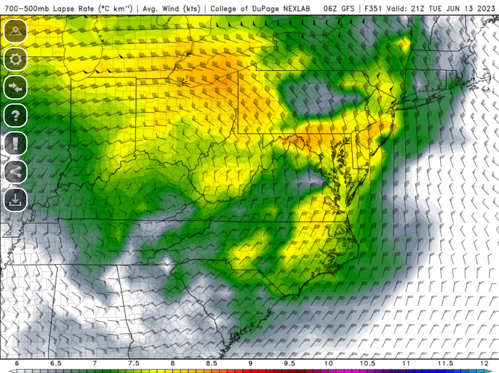
- 2,785 replies
-
- 3
-
-
- severe
- thunderstorms
- (and 3 more)
-
2023 Mid-Atlantic Severe Wx Thread (General Discussion)
Kmlwx replied to Kmlwx's topic in Mid Atlantic
CIPS extended range is showing some hope late in the period... But it's at range and it's not any major signal. -
2023 Mid-Atlantic Severe Wx Thread (General Discussion)
Kmlwx replied to Kmlwx's topic in Mid Atlantic
- 2,785 replies
-
- 2
-

-

-
- severe
- thunderstorms
- (and 3 more)
-
I guess I'm not missing any exciting weather back home while down in the Outer Banks. Hazard of doing a pre-Memorial Day trek down here I guess - it's WINDY and pretty chilly. Managed to get one good beach day in so far this week.
-
2023 Mid-Atlantic Severe Wx Thread (General Discussion)
Kmlwx replied to Kmlwx's topic in Mid Atlantic
Adding another post rather than editing...(mind vomit right now) I guess the point I was getting at was I think you're right in the sense that it's a relatively short period when we can really mix high shear with decent CAPE. Too far towards summer and we get closer to pulse season (not that a more dynamic event can't happen...but it would be more likely to be a ring of fire/cold pool driven event) - and too early and we don't have the high dews or instability yet - but shear/dynamics could be more impressive. If we aren't going to have storm threats...I'd much rather have the tolerable humidity and heat as long as possible. We all know that it's only a matter of time until we are all suffering in the 90s with dews in the upper 60s and 70s. -
2023 Mid-Atlantic Severe Wx Thread (General Discussion)
Kmlwx replied to Kmlwx's topic in Mid Atlantic
I think it often depends on what exact "type/style" of severe we are talking about. Certainly this time in May we still can have potentially strong "spring" systems that can provide a lot of shear. But sometimes we are lacking in instability still this early. It hasn't been a super hot/humid May so far (part of me says thank goodness...). I remember a ton of really good storm events June/July - but a lot of the July events were likely more "pulse" stuff with less shear available that just happened to be memorable for swaths of the area. Certainly agree that for "area wide" stuff we are starting to waste some climo peak. Our area seems to go on "runs" of severe streaks. Far too lazy to look at the SPC event archive right now - but I seem to remember that there were some other beefy severe days in 2008 and 2012 clustered in the same time neighborhood as the "big ones" It really only takes about 1-2 weeks of a run to make a year a massive severe year for us IMO. Throw in some sort of tropical/flooding event in late summer/early fall and we can really string together some meteorological madness. Just have to get the snow part of the puzzle back into the mix I'm heading down to the OBX form this coming Saturday to the following Saturday...I'm OK if nothing happens between those dates...selfish.- 2,785 replies
-
- 1
-
-
- severe
- thunderstorms
- (and 3 more)
-
If anyone is on the W shore of the bay between Mayo and Arundel on the Bay or on the S side of Kent Island - there are C-2 Greyhound airplanes doing racetracks over the bay at low altitude. Good photo-op for those in a position to snap pics. Maybe preparing for a flyover at the Naval Academy - but so far haven't directly passed over there.
-
I wonder if this is what the sky looked like in 1816 with the global volcanic eruption effects. Super heavy smoke and red sun is almost surreal to see.
-
2023 Mid-Atlantic Severe Wx Thread (General Discussion)
Kmlwx replied to Kmlwx's topic in Mid Atlantic
The CFS several times when I checked over the winter kept showing a ring of fire style pattern for Jun-ish.- 2,785 replies
-
- 5
-
-
- severe
- thunderstorms
- (and 3 more)
-
Can't wait to see the Drought Monitor map/discussion update next Thursday.
-
2023 Mid-Atlantic Severe Wx Thread (General Discussion)
Kmlwx replied to Kmlwx's topic in Mid Atlantic
CIPS has some interesting analogs in the mix. June 1, 2012 is in there- 2,785 replies
-
- 3
-
-
- severe
- thunderstorms
- (and 3 more)
-
Shame it's a bunch of months too late lol.
-
2023 Mid-Atlantic Severe Wx Thread (General Discussion)
Kmlwx replied to Kmlwx's topic in Mid Atlantic
Feb 7 was only a marginal day and even no watch was issued! Pretty impressive.- 2,785 replies
-
- 1
-
-
- severe
- thunderstorms
- (and 3 more)
-
2023 Mid-Atlantic Severe Wx Thread (General Discussion)
Kmlwx replied to Kmlwx's topic in Mid Atlantic
"Tasty" ~Yoda- 2,785 replies
-
- 3
-
-
-
- severe
- thunderstorms
- (and 3 more)
-
2023 Mid-Atlantic Severe Wx Thread (General Discussion)
Kmlwx replied to Kmlwx's topic in Mid Atlantic
If you want to spend the $$$ - you could also get a scanner to monitor local law enforcement/fire frequencies as well - most of them have NOAA capability with SAME as well. But those do tend to be MUCH more expensive versus a dedicated weather radio. Only useful if you're into scanning at all.- 2,785 replies
-
- 2
-
-
- severe
- thunderstorms
- (and 3 more)
