Kmlwx
-
Posts
13,431 -
Joined
-
Last visited
Content Type
Profiles
Blogs
Forums
American Weather
Media Demo
Store
Gallery
Everything posted by Kmlwx
-

2023 Mid-Atlantic Severe Wx Thread (General Discussion)
Kmlwx replied to Kmlwx's topic in Mid Atlantic
The CIPS analogs from the 0z suite had some decent ones mixed in. I saw June 4, 2008 lol- 2,785 replies
-
- 2
-

-
- severe
- thunderstorms
- (and 3 more)
-
2023 Mid-Atlantic Severe Wx Thread (General Discussion)
Kmlwx replied to Kmlwx's topic in Mid Atlantic
You're in here talking dirty to the severe weenies... Paging @Eskimo Joe - get us an EML and we can be sub-par on some other factors and still perform. -
2023 Mid-Atlantic Severe Wx Thread (General Discussion)
Kmlwx replied to Kmlwx's topic in Mid Atlantic
CIPS had a decent severe potential signal on the 168hr frame on the 0z suite.- 2,785 replies
-
- 1
-
-
- severe
- thunderstorms
- (and 3 more)
-
I might be misremembering - but I think the last time LWX was down for either part of SLEP or a major failure - we all thought it was going to be like a 10 day outage and it was back up on like the 6th day or something.
-
It figures that we start to see a potential uptick in severe potential in the coming days to next week while the LWX radar is down...Thanks for the answer! I also feel like they tend to work very fast on these - NWS ROC seems to underpromise and overdeliver at least in my experience with repair timelines. I'm guessing we could see it back in service early if the weather cooperates.
-
2023 Mid-Atlantic Severe Wx Thread (General Discussion)
Kmlwx replied to Kmlwx's topic in Mid Atlantic
Yep! I see we got a bit of a mention in the D4-8 outlook.- 2,785 replies
-
- 2
-
-
- severe
- thunderstorms
- (and 3 more)
-
I'm mainly using TIAD. Seems the feed from TBWI has been thready at best the last few weeks - lots of downtime. TDCA seems to miss some stuff over me - and I wonder if it's because it's a lower elevation versus areas to the west. Can the KLWX radar maintenance proceed even during rain?
-
737-500 I believe. At least that's what showed up on the website.
-
Snapped this picture of an unusual visitor to BWI earlier. Sierra Pacific Airlines has only two planes in their fleet. They last made a stop in Baltimore in late February. Seems they charter for military sometimes/often. Have been experimenting with an app called JetTip the past day or two. Has been cool to get an advanced heads up of "interesting" planes going into selected airports. Not a great picture - had to reduce it down a bit to fit on here.

-
Was just remarking about this to the family a few minutes ago. Beautiful out (other than the bugs). 70 degrees and falling at 8:30pm-ish after the middle of June with a dewpoint in the mid 50s is crazy.
-
2023 Mid-Atlantic Severe Wx Thread (General Discussion)
Kmlwx replied to Kmlwx's topic in Mid Atlantic
Indeed - SPC placed that slight risk in the right spots! -
2023 Mid-Atlantic Severe Wx Thread (General Discussion)
Kmlwx replied to Kmlwx's topic in Mid Atlantic
There was some spin I guess at high levels. Nothing near surface. Just an appendage really I think. And that Loudoun storm is crap now regardless.- 2,785 replies
-
- 1
-

-
- severe
- thunderstorms
- (and 3 more)
-
2023 Mid-Atlantic Severe Wx Thread (General Discussion)
Kmlwx replied to Kmlwx's topic in Mid Atlantic
Meh -
2023 Mid-Atlantic Severe Wx Thread (General Discussion)
Kmlwx replied to Kmlwx's topic in Mid Atlantic
Expansion of the existing watch to the south. They are sneaky like that sometimes when the area is not big enough for a new watch.- 2,785 replies
-
- 1
-
-
- severe
- thunderstorms
- (and 3 more)
-
2023 Mid-Atlantic Severe Wx Thread (General Discussion)
Kmlwx replied to Kmlwx's topic in Mid Atlantic
It looks like LWX/SPC coordinated a local expansion of the watch to the south. I'm still left out seemingly. Oh well.- 2,785 replies
-
- 1
-
-
- severe
- thunderstorms
- (and 3 more)
-
2023 Mid-Atlantic Severe Wx Thread (General Discussion)
Kmlwx replied to Kmlwx's topic in Mid Atlantic
I see you sneakily added the question mark -
2023 Mid-Atlantic Severe Wx Thread (General Discussion)
Kmlwx replied to Kmlwx's topic in Mid Atlantic
After the SPC issuing a MCD for 20% chance -
2023 Mid-Atlantic Severe Wx Thread (General Discussion)
Kmlwx replied to Kmlwx's topic in Mid Atlantic
MCD coming out - https://t.co/duty3P6Iy9 - Link may not be working yet. -
2023 Mid-Atlantic Severe Wx Thread (General Discussion)
Kmlwx replied to Kmlwx's topic in Mid Atlantic
That is a beefy cell - no competition and I don't see any outflow yet. Pretty atypical for our area. Of course now that I said it the next frame will gust out Lightning production has been a good indicator of path and intensity tendency with this. The lightning has tended to be SE or even S of the radar returns...some of that is likely the radar data lagging behind the radar update - but I'd say areas just south of the Potomac look great right now if it maintains.- 2,785 replies
-
- 1
-
-
- severe
- thunderstorms
- (and 3 more)
-
2023 Mid-Atlantic Severe Wx Thread (General Discussion)
Kmlwx replied to Kmlwx's topic in Mid Atlantic
Cell continues to look healthy. Track is not so great for me. Seems it will straddle or go just south of the Potomac. Looks good for places like Herndon - and further down the line DC proper. -
2023 Mid-Atlantic Severe Wx Thread (General Discussion)
Kmlwx replied to Kmlwx's topic in Mid Atlantic
Wonder if outflow from the Winchester area storm can start to pop some other activity. So far, situation matches up pretty well with HRRR runs. -
2023 Mid-Atlantic Severe Wx Thread (General Discussion)
Kmlwx replied to Kmlwx's topic in Mid Atlantic
The cell N of Winchester has a hail marker on it now. Bears watching. Uptick in lightning production in that one as well.- 2,785 replies
-
- 3
-
-
- severe
- thunderstorms
- (and 3 more)
-
2023 Mid-Atlantic Severe Wx Thread (General Discussion)
Kmlwx replied to Kmlwx's topic in Mid Atlantic
The stuff down in VA is legit. -
2023 Mid-Atlantic Severe Wx Thread (General Discussion)
Kmlwx replied to Kmlwx's topic in Mid Atlantic
Looking into the long range - the CFS still seems to want to setup the potential for some NW flow stuff in the heart of July (ridge centered over the middle of the country). Would be interesting if our entire severe season was kind of shifted a month or so later. -
2023 Mid-Atlantic Severe Wx Thread (General Discussion)
Kmlwx replied to Kmlwx's topic in Mid Atlantic
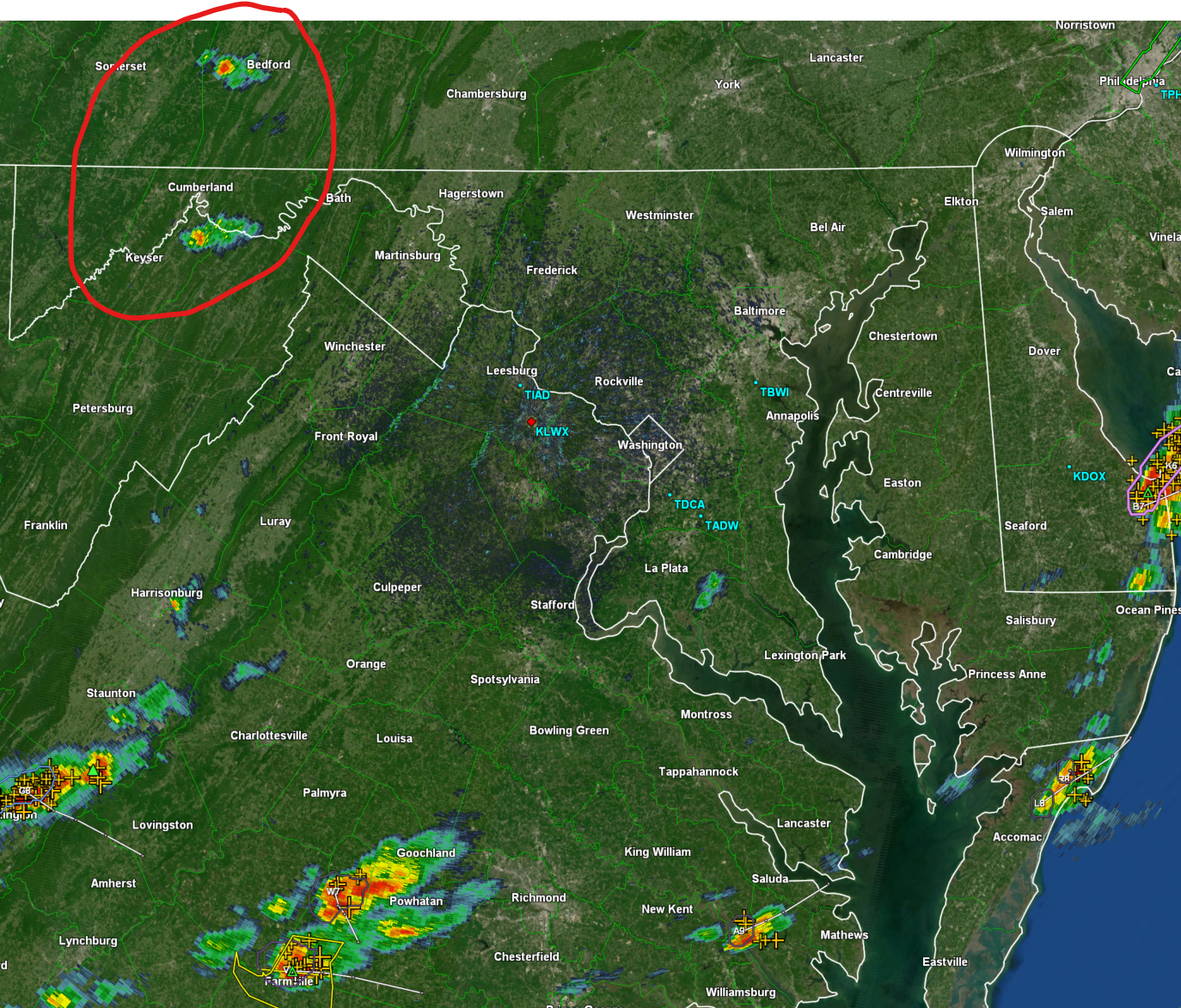
I'll still radar-watch all afternoon - keeping an eye on the red circled stuff.
- 2,785 replies
-
- 1
-
-
- severe
- thunderstorms
- (and 3 more)