

Kmlwx
-
Posts
13,551 -
Joined
-
Last visited
Content Type
Profiles
Blogs
Forums
American Weather
Media Demo
Store
Gallery
Everything posted by Kmlwx
-
Let's go for the biblical ice storm or the mass solar storm that sends us back to the 1800s.
-
I dunno - I know it had that rep before. This season it's been pretty gun shy on predicting big storms for us. ARW is actually less enthused than the ARW2. HRRR looks passable for this afternoon even. A tiny UH track over MoCo too It's REALLY dreary out right now, though. So we could fail on the instability side of things today. Pretty unusual for same areas to get it two times in two days. So I'm going to assume we either fail today or tomorrow. Tempted to put all my eggs in the tomorrow basket after reading the SPC disco and looking at the guidance. Even the GFS paints a decent amount of parameter space over the DC area tomorrow PM.
-
The ARW2 near the end of its run is VERY nice for the region.
-
I know it's not a great product to use - but UH tracks for both today and tomorrow are very respectable for this area... That's some nice language from SPC regarding tomorrow's outlook...especially because the TOR risk is already at 5%. September can be a good tor month around here...
-
I sort of alluded to that earlier. I feel like that would have been a no brainer high risk day if it had not been a tropical system. I don't think they go above slight if it is related to tropical or tropical remnants. That's definitely something that maybe should be discussed. I get that the scale is supposed to denote the severity level - but the nature of categorical probs also is that COVERAGE and number of occurrences (regardless of intensity/magnitude) also go into the scale. 40 tornadoes should be a high even if they are all EF-0s... We could get into the whole terminology debate too. I like that local mets have switched to saying "it's a 1 out of 5" on the scale for today. Rather than using the terms like "slight" - I've always been of the opinion that slight/mod/high is the wrong term set for the general public.
-
My mom just told me the other day that my 2nd cousins that I remember giving piggy back rides to are well into high school. Crazy.
-
The other thing you have to remember - even with high confidence...the higher the outlook the higher the "egg on face" potential for SPC. There's already the old saying that meteorologists are always wrong...very few SPC forecasters would have the stomach to call a high risk for the nation's capital unless it was absolutely necessary. It's one thing to call a high where the local population understands what the risk categories mean and are familiar with severe weather. DC tends to have a "panic mode" inherently built into the population (just look at 495 with a half inch of snow). Can you imagine what a high risk would do to lay people around here?
-
It's truly hard to believe that 2012 was already almost a decade ago. I agree - I think that had we had a good handle that the complex would maintain intensity as it approached, we could have qualified for a high. The sheer number of reports backs that up. If there was the equivalent of "post season analysis" like they do for hurricanes, that could have been a high risk day IMO. I doubt we ever see a TOR based high risk in this area. Although...isn't it more about the number of reports than the intensity of individual events? Say we had a vigorous system (perhaps tropical in nature or hybrid) and it was clear that while there wouldn't be EF-5 stuff...we'd get a large amount of EF-0 to EF-2 and it was high confidence - would that be enough to trigger a high hypothetically? I doubt SPC would ever do that for a tropical system, though.
-
I think the Northeast as a whole has seen one total high risk in history. I think it would be more likely for us to see a PDS Severe Thunderstorm Watch than a high risk. But - @high risk has a point. A lot of the outlook is based on predictability. If we have a CLEAR and OBVIOUS case of a massive severe outbreak days out ahead and it holds as we close, there could be a high risk at some point. And who knows what the future of the local climate will hold...
-
Talk about a "cute lil slight" for Thursday.
-
Outflow also coming south from the MoCo/HoCo line now. May be some new development where the boundary coming SE from Frederick meets up.
-
Development occurring in a more favorable position for closer to DC (warning on the cell near Bath now).
-
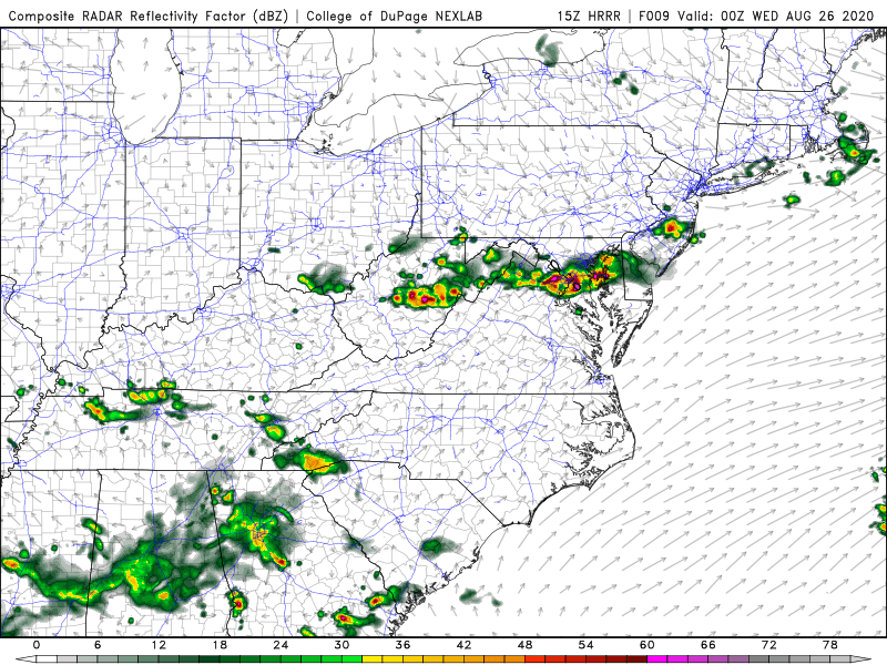
HRRR has multiple waves for decent chunks of the area.
-
SPC Outlook even has "the look" to back that up.
-
Radar trajectory of the stuff up in PA looks decent for now.
-
You're entire "persona" on here has gotten about as old as it can possibly get. Global models are not going to have a good handle on individual storms until there is some sort of actual center of circulation - and even then they can struggle. Nobody on this forum needs you posting the same crap on an hourly basis. It's global models - they might show a storm today and won't tomorrow. In the end - there might be a monster or a piece of crap exposed center. If you're truly a "weather enthusiast" you should really try to absorb some of the excellent posts on here from meteorologists and non-trolls. Posting a little less and taking in some of the knowledge is great advice.
-
Complete turd.
-
-
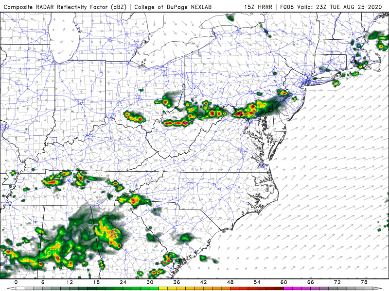
15z HRRR rolling in now is pretty robust for the metro area.
-
That little cluster seems to have overperformed. There are already 3 LSRs showing up in the wake of it.
-
I would think if they hang around too long they might reduce the risk over in NoVA. But Central Maryland and other areas still seem like a decent risk area (as evidenced by SPC area).
-
23-1z seems fine to me. It's not overnight - and it's still summer so there should still be enough instability around that time. Plus, these things do tend to come in just a touch ahead of schedule. Also that cluster in NoVA right now could lay down some additional boundaries to enhance later convection.
-
NAM nest and HRRR actually look pretty decent - especially the NAM nest - even some UD helicity tracks lol
-
After seeing outlooks like 6/29/12 I tend not to rule *anything* out completely until we are right up on the event. We've seen several/many times when we are barely in a 5% and end up in a higher end SLGT or even moderate. Not saying the setup is at all similar to that - just comparing how things can shift/evolve with severe.
-
NICE inverted V signature on that sounding. Also...anybody see the day 3 hatching well to our north? Wow.


