

Kmlwx
-
Posts
13,549 -
Joined
-
Last visited
Content Type
Profiles
Blogs
Forums
American Weather
Media Demo
Store
Gallery
Everything posted by Kmlwx
-
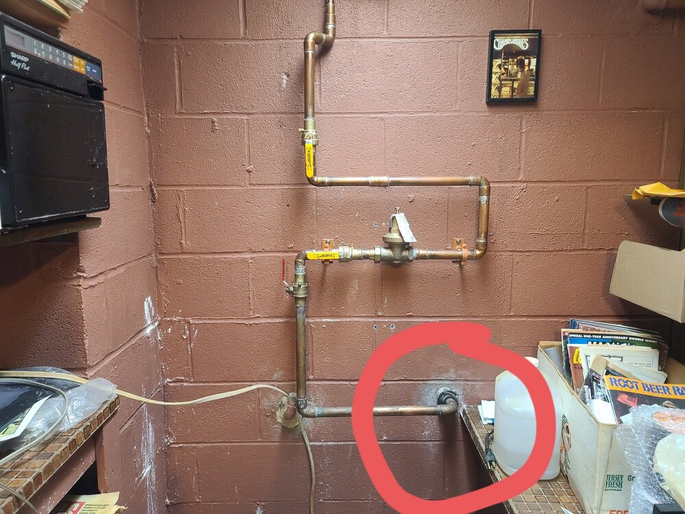
It looks like that point where it enters that reddish wall in the picture is PVC with a boot sort of thing before it goes over to the copper style piping shown in the picture. THe leak has finally slowed to just an occasional drip - telling me it's definitely rain related. We are still waiting for the plumber though. What a night - hoping the rain stays away until this is fixed. Thanking past-me for insisting on sticking a few battery operated water alarms down there.
-
Replying here even though it's banter (I posted an image over in there as well). I managed to get a few hours of shut eye. Good news is the leak pretty much stopped/slowed now that the rain has been gone for a while. One of the neighbors was here just now and said it seemed like it might just be where the service line meets the internal piping. There's an area that looks like PVC style piping where it comes into the basement and then it goes back over to copper - he thinks the "boot" might just be loose. We are still waiting for the plumber - hopefully we can avoid anything new until he gets here. I'm wishing the rain away for now. A water alarm saved our butts...I heard it going off and we managed to scramble to figure out the cause.
-
Taken last night -
-
Peaked just above flood stage and is now back down into action stage. ETA: Looks like highest crest since 12/2018. Provisional data is around 9.31ft crest.
-
Well - main water line is leaking into basement, tree is down blocking entire road. Glad this latest batch mostly missed MBY. CLAM2 (Colesville stream gauge) hit flood stage.
-
Looks like our main water line into the house is leaking perhaps at the point where it enters the house. Weird that it would coincide with heavy rain...which tells me maybe it's rain related and not overtly a water supply line issue. None of the 24 hour services seem to have anything until later in the morning - so we are holding for our plumber. Any ideas?
-
Lull coming soon.
-
Near Sligo Creek Pkwy and Maple. https://waterdata.usgs.gov/md/nwis/uv/?site_no=01650800&PARAmeter_cd=00065,00060,62615,62620
-
It just updated (must be hourly at night maybe)...but it's showing a decent rise at the 11:45pm update. 210cfs for discharge and 2.79ft
-
Places like @H2O - definitely don't even need moderate rain - let alone heavy. House here is OK as we are on a hill - though a little puddling can come into the garage (I just put in a new seal the other day!). That was some impressive rainfall IMBY for a time - it's a bit lighter for the moment.
-
The coordinates for it put it near that old bridge that's closed off. It seems like it's just a hair south of actual Randolph Rd. This time of year probably not visible from the road - but perhaps in winter?
-
It does seem there will be a lull (no backbuilding at the moment) behind this stuff and ahead of the next wave to the south (if that stuff survives up here, that is)
-
For archival sake -
-
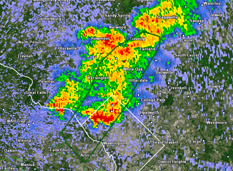
What a deluge out there - NWS posted a flash flood warning now. Well warranted if this keeps up. I'm keeping an eye on the USGS gauge on NW Branch near Kemp Mill Rd. EDIT: The gauge hasn't updated since 0245z (about an hour ago at this point). It does generally lag a bit - but normally only by 30-45 mins. Suspect that the next update will show rising water at this point. Link below for both of you as it should be fairly representative for any creeks in our area. https://waterdata.usgs.gov/md/nwis/uv/?site_no=01650500&PARAmeter_cd=00065,00060,62615,62620 https://water.weather.gov/ahps2/hydrograph_to_xml.php?gage=clam2&output=tabular
-
Dumping here in Colesville, MD. Power is out as well.
-

2021 Atlantic Hurricane Season Tracking Thread
Kmlwx replied to WxWatcher007's topic in Mid Atlantic
Fred is having a big blowup of convection right now... -
Not surprised, honestly. Given how quickly they got drenched the other night...not going to take much to get those torrents of water rising again. There's been some really neat radar depictions the past week or two as well.
-
Pre-emptive FFW out already.
-
2021 Atlantic Hurricane Season Tracking Thread
Kmlwx replied to WxWatcher007's topic in Mid Atlantic
For the GEFS versus the GEPS - the GEPS would be much more likely to bring us impacts locally (available on TropicalTidbits). -
2021 Atlantic Hurricane Season Tracking Thread
Kmlwx replied to WxWatcher007's topic in Mid Atlantic
18z NAM takes the center of the remnants on a pretty different track compared to the 18z NAM nest. NAM nest is pretty far north and west with the center around our region...12km NAM would seemingly be better for a closer in pass. -
Decent amount of rain on radar between Stafford and the US-22 area east of Culpeper. Suspect the splotchy radar we've seen the past few days will continue.
-
That was crystal clear in the new normals data
-
2021 Mid-Atlantic Severe Weather - General Discussion
Kmlwx replied to Kmlwx's topic in Mid Atlantic
No risk area on the D3 SPC outlook. So that means at this range we are absolutely in business -
The good old fashioned "rubber band theory" - snap back far in the other direction!
-
2021 Mid-Atlantic Severe Weather - General Discussion
Kmlwx replied to Kmlwx's topic in Mid Atlantic
Certainly not expecting an Ivan-esque outbreak - but there seems to be some decent agreement now that the remnants will post an iso tor threat (as well as some isolated flooding risk as well). What a wet pattern lately!


