

Kmlwx
-
Posts
13,549 -
Joined
-
Last visited
Content Type
Profiles
Blogs
Forums
American Weather
Media Demo
Store
Gallery
Everything posted by Kmlwx
-

2021 Mid-Atlantic Severe Weather - General Discussion
Kmlwx replied to Kmlwx's topic in Mid Atlantic
Though at this moment I'd tend to agree with the doo doo assessment. We'll see how things play out for the remainder of the afternoon. I see a warning up in PA now. -
2021 Mid-Atlantic Severe Weather - General Discussion
Kmlwx replied to Kmlwx's topic in Mid Atlantic
And...cells won't look particularly beefy in a setup like this. Even the stuff in PW and Loudoun right now could produce even if reflectivity doesn't look like textbook severe. -
2021 Mid-Atlantic Severe Weather - General Discussion
Kmlwx replied to Kmlwx's topic in Mid Atlantic
TDCA has a nice tiny cell just south of Alexandria. I know models yesterday were focusing any 2nd line on the northern parts of the area. -
I know there was some work done on that area of piping last year - but not sure if it was that exact part where the line comes into the house. It may have been pretty darn old. The amount of water that was coming in was definitely more than a little. I'm pretty sure had we not had the water alarms we'd have woken up in the morning to a decent amount of flooding in the basement. We haven't had anything like the rain from that night since then - but a few downpours and there's been zero leaking. We've got a dehumidifier running now to dry things out. Added two more water alarms to other parts of the basement. For $11 and a 9V battery - it's so worth it. House is near our street (up on a hill though) - but it's a dead end street. Probably fewer than 10 cars a day drive on it.
-
Little tropical shower here in Colesville, MD now.
-
2021 Mid-Atlantic Severe Weather - General Discussion
Kmlwx replied to Kmlwx's topic in Mid Atlantic
That's certainly the dominant cell right now. The little cluster north in Loudoun has lost a lot of its punch. This is a pretty classic looking tropical remnants radar depiction for us. There's a lot of junk east of that primary corridor, though - wonder if that may serve to dampen instability a bit. Though - it's not one of those events we need 3K CAPE for. 500-1000 will probably be sufficient. The stuff south of Bowling Green also bears watching as it gets further north. -
2021 Mid-Atlantic Severe Weather - General Discussion
Kmlwx replied to Kmlwx's topic in Mid Atlantic
That corridor is looking better with time. -
2021 Mid-Atlantic Severe Weather - General Discussion
Kmlwx replied to Kmlwx's topic in Mid Atlantic
This is probably the corridor to watch. One thing to note - we won't be looking for towering supercells today. This type of setup could produce little/brief spinnys even from cells that don't look terrible impressive in terms of base reflectivity.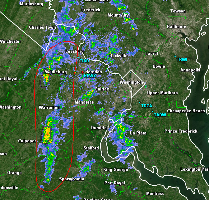
-
2021 Mid-Atlantic Severe Weather - General Discussion
Kmlwx replied to Kmlwx's topic in Mid Atlantic
https://www.wpc.ncep.noaa.gov/metwatch/metwatch_mpd_multi.php?md=822&yr=2021 -
2021 Mid-Atlantic Severe Weather - General Discussion
Kmlwx replied to Kmlwx's topic in Mid Atlantic
It's what sells clicks and follows though. -
2021 Mid-Atlantic Severe Weather - General Discussion
Kmlwx replied to Kmlwx's topic in Mid Atlantic
Gotta love the all caps and danger red font. -
2021 Mid-Atlantic Severe Weather - General Discussion
Kmlwx replied to Kmlwx's topic in Mid Atlantic
That Baltimore cell even looks a little interesting. -
2021 Mid-Atlantic Severe Weather - General Discussion
Kmlwx replied to Kmlwx's topic in Mid Atlantic
Radar still is pretty tame. We'll see how the next hour or two unfolds. There is a warning NW of us up in PA. -
2021 Mid-Atlantic Severe Weather - General Discussion
Kmlwx replied to Kmlwx's topic in Mid Atlantic
Interesting that it tends to be the HRRR that is lackluster due to the low dews on that model. -
2021 Atlantic Hurricane Season Tracking Thread
Kmlwx replied to WxWatcher007's topic in Mid Atlantic
The trend is our friend. In all honesty - that member is pretty strong even once it gets into the metro area. It brings the center almost over MBY. Would be an ugly setup for the western side of the bay. -
2021 Atlantic Hurricane Season Tracking Thread
Kmlwx replied to WxWatcher007's topic in Mid Atlantic
That member is even just a hair west of the Bay. Imagine that. -
2021 Atlantic Hurricane Season Tracking Thread
Kmlwx replied to WxWatcher007's topic in Mid Atlantic

-
2021 Mid-Atlantic Severe Weather - General Discussion
Kmlwx replied to Kmlwx's topic in Mid Atlantic
I'm already semi intrigued by the cell near CHO. -
2021 Mid-Atlantic Severe Weather - General Discussion
Kmlwx replied to Kmlwx's topic in Mid Atlantic
Maybe you can score a tail-end charlie -
2021 Mid-Atlantic Severe Weather - General Discussion
Kmlwx replied to Kmlwx's topic in Mid Atlantic
You're now Eskimo Joe. -
There was a tear in the seal it sounded like. Plumber resolved without issue. Although...we can't be for sure until it pours rain again I guess. But there has been no leaking all day. We added a few more water alarms just to be safe. Probably will be a little on edge for the first rainstorm or two after the repairs. Neighbors house we are watching had some plumbing issues as well - what a week!
-
FFG is probably pretty low in parts of SE MoCo and Fairfax at this point. There's already renewed radar returns near Standardsville, Stafford/S of Manassas. Wouldn't take much to get flooding again. Further, The NAM 12km might miss smaller scale features that could still drop heavy rainfall.
-
2021 Mid-Atlantic Severe Weather - General Discussion
Kmlwx replied to Kmlwx's topic in Mid Atlantic
This. There's always someone -
Sounds like the plumber will be here semi soon. Hopefully it's just that seal/boot and we can call it a day. Glad I'm not working in the office today.
-
During all the heavy rain storms this house has been through - never had this happen before. I know the main water line in the front yard was completely replaced due to a leak when I was a youngster. We are crossing our fingers it is not the supply line. I would think if it was pure rain water going through the ground it would be more discolored than it is. I don't think it's even brown...


