

Kmlwx
-
Posts
13,549 -
Joined
-
Last visited
Content Type
Profiles
Blogs
Forums
American Weather
Media Demo
Store
Gallery
Everything posted by Kmlwx
-

2021 Mid-Atlantic Severe Weather - General Discussion
Kmlwx replied to Kmlwx's topic in Mid Atlantic
Wind core becoming apparent on most of the TDWRs and LWX radar near Kensington/Garrett Park -
Except it'll probably cycle 5+ times before we actually get to actual fall. We'll be lucky to see "fall" before Halloween :'(
-
2021 Atlantic Hurricane Season Tracking Thread
Kmlwx replied to WxWatcher007's topic in Mid Atlantic
Just saw a tweet about a major outbreak of lightning (and positive strokes) near the center. Could be about to take off. -
2021 Atlantic Hurricane Season Tracking Thread
Kmlwx replied to WxWatcher007's topic in Mid Atlantic
Gotta wonder if any remnants for us could take an Ivan-esque approach to our region (not including the odd loop Ivan did back to the Gulf, of course). -
2021 Mid-Atlantic Severe Weather - General Discussion
Kmlwx replied to Kmlwx's topic in Mid Atlantic
Some nice velocity scans on the DC cell(s) from the TDCA radar. -
Yep - cannot wait for the first strong cold front to break the back of summer. I know late August is still pretty early...just hoping it's not one of those years where we wait until early October to truly knock down the temps. I'm sure a big front will come through in September - but we can rebound behind those if the return flow and H5 pattern is "right"
-
2021 Atlantic Hurricane Season Tracking Thread
Kmlwx replied to WxWatcher007's topic in Mid Atlantic
September 2097 -
Definitely one of those events where I remember exactly (with stunning detail) what I was doing when it hit. Derecho in 2012 was another one - as is June 4, 2008.
-
I heard on WTOP the other day that for 100% completion it could be "another 10 years"
-
This thread is my signature claim to fame.
-
It's kind of sad that we could get a day or two relief even during peak heat back in July - but here we are in August with just endless soup air.
-
Silver Spring (downtown) looks like they are getting dumped on. Very little movement with this activity. Could pose a renewed FF risk if it's not short lived.
-
2021 Atlantic Hurricane Season Tracking Thread
Kmlwx replied to WxWatcher007's topic in Mid Atlantic
The one thing NE has going for them is the geography. Similar to how Hatteras gets hit because it juts out from the coast - similar geography for places like Cape Cod. I imagine if the Delmarva had a big appendage jutting east - the region would have more tropical. -
Was driving back from Annapolis this morning - not a fun drive!
-
2021 Mid-Atlantic Severe Weather - General Discussion
Kmlwx replied to Kmlwx's topic in Mid Atlantic
The fat lady is warming up. -
2021 Mid-Atlantic Severe Weather - General Discussion
Kmlwx replied to Kmlwx's topic in Mid Atlantic
Still not really much development going on to the south of that line. Nice storm for HGR though it seems. -
2021 Mid-Atlantic Severe Weather - General Discussion
Kmlwx replied to Kmlwx's topic in Mid Atlantic
Parameters remain decent - earlier mesoscale discussion indicates there is still some hope for renewed activity. -
Must be a microclimate - cloudy here.
-
2021 Mid-Atlantic Severe Weather - General Discussion
Kmlwx replied to Kmlwx's topic in Mid Atlantic
There is likely to be renewed activity. Where exactly that impacts remains to be seen. -
2021 Mid-Atlantic Severe Weather - General Discussion
Kmlwx replied to Kmlwx's topic in Mid Atlantic
Both of those cells look "hooky" on TBWI. They look less good on LWX. But they are definitely "mini" -
2021 Mid-Atlantic Severe Weather - General Discussion
Kmlwx replied to Kmlwx's topic in Mid Atlantic
Watching it on TBWI. It looks like it could be the real thing if it keeps improving. ETA: ARea near Woodstock, MD also now looking interesting on TBWI. -
2021 Mid-Atlantic Severe Weather - General Discussion
Kmlwx replied to Kmlwx's topic in Mid Atlantic
Watch the area near Laurel/Maryland City. There is a hint of something trying there. -
2021 Mid-Atlantic Severe Weather - General Discussion
Kmlwx replied to Kmlwx's topic in Mid Atlantic
This is sort of what I foresee us watching for later on. Again, best odds north of I-70.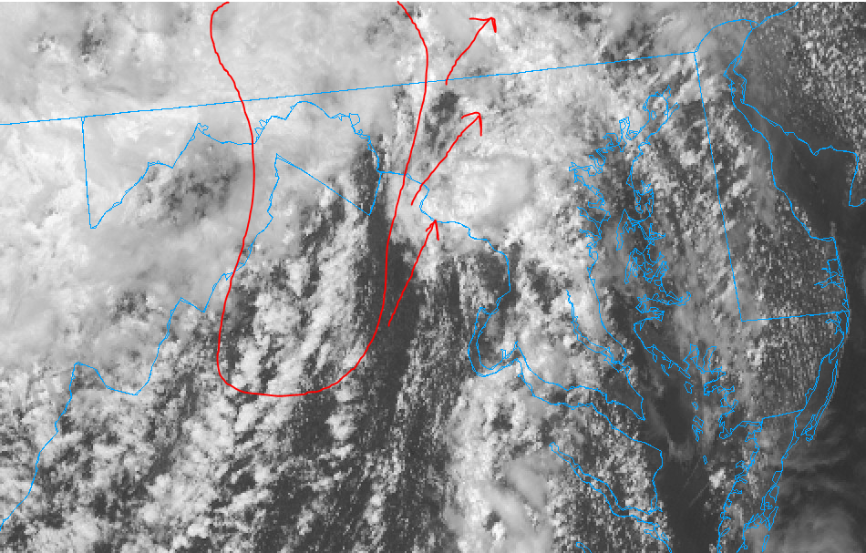
-
2021 Mid-Atlantic Severe Weather - General Discussion
Kmlwx replied to Kmlwx's topic in Mid Atlantic
We are paying back for the flooding rains in parts of the area the past week or so - and all the pulse severe. In all seriousness - maybe we just bought too heavily into this stuff. Big time pocket of clearing behind this stuff. -
2021 Mid-Atlantic Severe Weather - General Discussion
Kmlwx replied to Kmlwx's topic in Mid Atlantic
16z HRRR buys into the 2nd line later being the dominant one. But it's mainly for I-70 and north.


