

Kmlwx
-
Posts
13,549 -
Joined
-
Last visited
Content Type
Profiles
Blogs
Forums
American Weather
Media Demo
Store
Gallery
Everything posted by Kmlwx
-
This is a solid idea. I've heard good things about groups.io - We can also enable a waiting room to screen people as they enter. But probably easiest just to have a semi-secure place for people to check for the passcode. There's a decent amount of security options in Zoom too - (waiting room, passcode, authentication required etc).
-
Does seem like they declare it over when parts of counties do not actually reach freezing. Probably just easier to do it that way - and then not have to issue the products again until spring.
-
Could be fun/informative to do a weekly "broad pattern check-in/analysis" roundtable Zoom meeting during the winter months. Have a few speakers and everyone else on mute unless there's a Q+A period. This being of course in addition to a general "meet and great/hangout" Zoom.
-
"Reapings here! - Walk-ins welcome!"
-
Muting, and kicking people out can be done by hosts/co-hosts. I'm not sure how many people we have in this subforum that would deliberately waste time in pretending to be someone else. We aren't that large of a community like reddit - and really the "impostor" would not gain anything. If somebody wants to impersonate me - go ahead.
-
Would be nice to keep it to us Mid-Atlantic folks. Of course I know some of the great mets are from outside our region - but it would be nice to have a subforum specific Zoom rather than a full on AmWx free-for-all. Expanding it to all of AmWx would be far too difficult to moderate and control entries. As it is - I think a waiting room and passcode could be useful to avoid any trolls from joining.
-
At this point it might as well be a symposium!
-
How many weenies will @Ji - push off the cliff on these Zoom calls, though
-
Generalizing here - but that would all but eliminate having the older folks on the forum join a video call. Discord is weighted so heavily towards the younger gaming crowd. Again...I am generalizing and I know some older people who do use it and game. Discord would be best for the 30 and under crowd. At this point with COVID and such - you'd be hard pressed to find people who have never heard of Zoom. Even the park police volunteers I work with outside of work (most of them are 60+) have been able to join Zoom calls and be totally fine.
-
Also @psuhoffman - chats are retained at least in our tier of Zoom. Everything from transcript to chat to video/audio is all stored and can be downloaded as well.
-
I am the Zoom guru at my firm and have access to unlimited meetings for 300 attendees. Also allows for recording and transcripts. Happy to provide a venue if needed.
-
New development near Bowling Green and back towards Palmyra, VA.
-
Interesting cell has formed down near Goochland. Much further west than the main activity.
-
Fairfax County Police is of course being tight lipped. But supposedly it was a pretty specific piece of information from federal partners.
-
CIMMS probs are back up on that line.
-
The trajectory looks good for even MoCo and DC for now.
-
Some sort of line appears to be forming between Culpeper and down to the Bowling Green area.
-
Does seem there could be a brief few hour period when Wind Advisory criteria is met in a more widespread area than the advisory currently covers. We'll see what LWX does this morning. Overall duration should be short, however.
-
-
PEPCO already up to 5K outages. Been a fairly steady rise this morning. East wind is the enemy of trees around here.
-
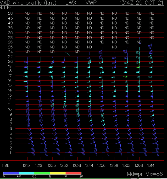
VAD winds from LWX
-

What is the Biggest Snowstorm That is Theoretically Possible For Us
Kmlwx replied to SnowenOutThere's topic in Mid Atlantic
Probably around 3ft in the more populated areas (not including south and east of the fall line). -
39.9 showing on my cheapo thermometer.
-
Would like to add - I am *not* brave enough to fall out of an airplane. Was pooping myself and considering asking the instructor to just take me back down in the airplane the entire way up. I jumped second - and watching that first woman go was eye opening. Apparently everyone else got to slide to the door on their butts - my instructor made me stand and essentially shoved me out. Can confirm - even after this I am still afraid of bugs.


