

Kmlwx
-
Posts
13,549 -
Joined
-
Last visited
Content Type
Profiles
Blogs
Forums
American Weather
Media Demo
Store
Gallery
Everything posted by Kmlwx
-
It's continued to look pretty decent. However, LWX hasn't warned it at all. The rotation at times has been pretty broad and not "tight" - we'll see
-
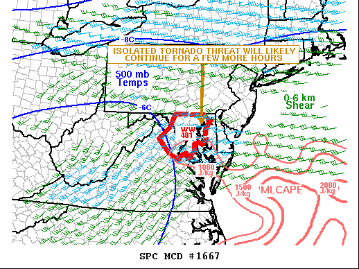
https://www.spc.noaa.gov/products/md/md1667.html
-
Radar estimates somewhere in the neighborhood of 1.5-2.3 inches fell during that storm IMBY. That's almost as much as some of the models had for me for the entire even - just goes to show you that while global and even mesoscale model output is a good guide - individual cells/clusters can boom or bust your total pretty easily. Add in whatever comes later today (and any showery stuff in between) and we could easily get some beefy rain totals even though guidance had the worst flood threat NW.
-
We've seen LWX warn similar storms. If it keeps up another scan or two I bet it'll get tor warned. Looks decent on the TDWRs AND the KLWX radars.
-
Area near Glenarden, MD showing signs of cycling up. We'll see if it can sustain this time. That may warrant a TOR in short order if it continues.
-
Having the TDWRs is so nice in these cases. Though it often seems the TDCA and TADW have trouble seeing up my way in terms of velocity.
-
Something may be trying to organize right along the river crossing into DC. Suspicious on velocity.
-
About as high as I've seen that CIMSS prob severe product go in our area. This supercell is outlined with 92% wind 39% tor probs.
-
Some of the higher tilts velocity scans are showing nice rotation a bit off the deck SW of Falls Church. Wow.
-
The TOR probs on the CIMSS product @Eskimo Joe - shared a while back are really ticking up on this complex. It looks legit... For those that don't have it - here is the placefile (can be used in GR) http://cimss.ssec.wisc.edu/severe_conv/NOAACIMSS_PROBSEVERE
-
I set my alarm for 2:15 - probably could have snuck another hour or so in at least IMBY. Probably wise to go back to sleep after this stuff passes. Southern end of that cluster is worth watching too.
-
Got to give the HRRR credit here...it consistently (for many runs in a row) showed a cell like this cutting through the area in this timeframe.
-
Area near Centreville may be trying to cycle up again. It's got a severe thunderstorm warning on it now. Worth watching.
-
I'm not high risk - but it depends on the model output you are referring to. Some maps are 6hr precip, some are 24hr etc. Some are also simply "total precip" If it was total precip - then certainly yes any rainfall already down would count.
-
The last few runs have seemingly brought some sort of cellular/cluster activity over DC or nearby areas. Some of the runs have shown a decent UH track as well. It honestly wouldn't surprise me...tropical stuff can do weird off-hours stuff for us. Not sure it'd be enough for a tornado watch...but if we do get one - it could be one of those rare days where we have 2+ tornado watches in a single day.
-
HRRR definitely seems to indicate there could be a predawn threat as well
-
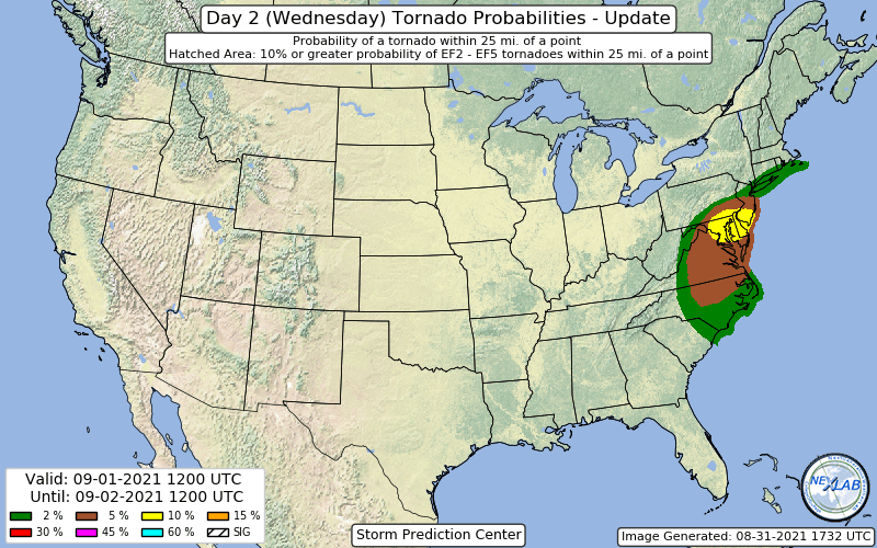
10% TOR
-
They did it!
-

2021 Mid-Atlantic Severe Weather - General Discussion
Kmlwx replied to Kmlwx's topic in Mid Atlantic
Eh - with the water "incidents" you and I have both had recently...thinking we can pass on the rain if it means having some exciting radar watching for spinnys. Even on the dry days our lawn has been like a saturated sponge when you walk on it. -
2021 Mid-Atlantic Severe Weather - General Discussion
Kmlwx replied to Kmlwx's topic in Mid Atlantic
I'm definitely a little more "pumped" than I was for our last tropical event. Seems we are in a better position for some activity. -
2021 Mid-Atlantic Severe Weather - General Discussion
Kmlwx replied to Kmlwx's topic in Mid Atlantic
For giggle - This is the 18z NAM (12km) for Wednesday PM.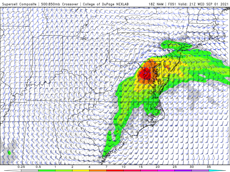
-
2021 Atlantic Hurricane Season Tracking Thread
Kmlwx replied to WxWatcher007's topic in Mid Atlantic
And this is all assuming there's even a storm that resembles that in 10 days -
2021 Atlantic Hurricane Season Tracking Thread
Kmlwx replied to WxWatcher007's topic in Mid Atlantic
I'm not him...but yeah - that's a pretty vigorous trough as depicted. But it's also 240 hours out. So.... -
2021 Mid-Atlantic Severe Weather - General Discussion
Kmlwx replied to Kmlwx's topic in Mid Atlantic
Worst wind just missed me. Traffic cams really shaking around on US 29 in Silver Spring -
2021 Mid-Atlantic Severe Weather - General Discussion
Kmlwx replied to Kmlwx's topic in Mid Atlantic
Looking better each scan it seems. Looks to head in my general direction. Kensington to White Oak look to be pummeled

