

Kmlwx
-
Posts
13,549 -
Joined
-
Last visited
Content Type
Profiles
Blogs
Forums
American Weather
Media Demo
Store
Gallery
Everything posted by Kmlwx
-

2021 Mid-Atlantic Severe Weather - General Discussion
Kmlwx replied to Kmlwx's topic in Mid Atlantic
Initiation in the vicinity of the higher terrain in VA. -
2021 Mid-Atlantic Severe Weather - General Discussion
Kmlwx replied to Kmlwx's topic in Mid Atlantic
HRRR brings activity in - but it's not all that intense - but wonder if it is a result of the overmixing of the model that @high risk has mentioned. -
2021 Mid-Atlantic Severe Weather - General Discussion
Kmlwx replied to Kmlwx's topic in Mid Atlantic
DCAPE is lower than previous days at least at this early hours. PWATS are 1.9 - soupy! -
2021 Atlantic Hurricane Season Tracking Thread
Kmlwx replied to WxWatcher007's topic in Mid Atlantic
MEH! Would rather it go west of us That's a wild run! -
2021 Mid-Atlantic Severe Weather - General Discussion
Kmlwx replied to Kmlwx's topic in Mid Atlantic
Would be a fun Friday if so. -
2021 Mid-Atlantic Severe Weather - General Discussion
Kmlwx replied to Kmlwx's topic in Mid Atlantic
Had a good streak this week. I'm okay with a dud day at this point. Almost time to start looking for east coast tropical too OT - but I really hope we are done with 95+ after this heat wave ends. Past August 15th I'm going into fall mode and hunting the first fall cold front. -
2021 Mid-Atlantic Severe Weather - General Discussion
Kmlwx replied to Kmlwx's topic in Mid Atlantic
Radar is void of anything. Thinking today will probably end with nothing for most of us. -
2021 Mid-Atlantic Severe Weather - General Discussion
Kmlwx replied to Kmlwx's topic in Mid Atlantic
Even ML lapse rates are good... -
2021 Mid-Atlantic Severe Weather - General Discussion
Kmlwx replied to Kmlwx's topic in Mid Atlantic
Some really beefy instability out there today. Imagine if there was a defined and focused trigger...and shear... -
2021 Mid-Atlantic Severe Weather - General Discussion
Kmlwx replied to Kmlwx's topic in Mid Atlantic
Saw a brief 60-65mph pixel on one of the TDWRs. The worst definitely missed me in Colesville just south. Pretty good string of storm days around the area. While not every locale has been hit daily - many are cashing in. -
2021 Mid-Atlantic Severe Weather - General Discussion
Kmlwx replied to Kmlwx's topic in Mid Atlantic
Lightning strike to a house in Gaithersburg. Lots of damage reports spanning from around North Bethesda to the Holy Cross Hospital area. -
2021 Mid-Atlantic Severe Weather - General Discussion
Kmlwx replied to Kmlwx's topic in Mid Atlantic
Radar looks pretty meh for that metro area warning - granted I haven't looked at the TDWRs -
2021 Mid-Atlantic Severe Weather - General Discussion
Kmlwx replied to Kmlwx's topic in Mid Atlantic
http://cimss.ssec.wisc.edu/severe_conv/NOAACIMSS_PROBSEVERE -
2021 Mid-Atlantic Severe Weather - General Discussion
Kmlwx replied to Kmlwx's topic in Mid Atlantic
Some big a$$ polygons today now from LWX. That placefile for GR that EJ sent a few weeks ago (maybe longer?) is spectacular. Love how conservative it is. -
2021 Mid-Atlantic Severe Weather - General Discussion
Kmlwx replied to Kmlwx's topic in Mid Atlantic
The TDWRs have some sort of boundary in an arc shape from near Laurel to the eastern side of the beltway and then down towards ADW. Is that the bay breeze? Movement seems a little off for the bay breeze, though. -
2021 Mid-Atlantic Severe Weather - General Discussion
Kmlwx replied to Kmlwx's topic in Mid Atlantic
Pretty good example of outflow in VA - everything behind that arc of outflow between say Middleburg and just N of Culpeper has gotten very meh-worthy. But north and south of that are still cranking away with good cells.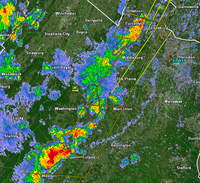
-
2021 Mid-Atlantic Severe Weather - General Discussion
Kmlwx replied to Kmlwx's topic in Mid Atlantic
Latest radar interpretation: Cell heading for Culpeper is pretty nice looking. And the Boonsboro area cell still is packing a punch. Purcellville cell has a hail marker now - so that may be pulsing up. Everything between there and the Culpeper cell, though looks meh. -
2021 Mid-Atlantic Severe Weather - General Discussion
Kmlwx replied to Kmlwx's topic in Mid Atlantic
Know you've mentioned this in past events too. Something is whacky with my hygrometer it seems - reading an 84 Td right now -
2021 Mid-Atlantic Severe Weather - General Discussion
Kmlwx replied to Kmlwx's topic in Mid Atlantic
Not often you see solid warnings from M/D line now all the way down to Madison, VA. -
2021 Mid-Atlantic Severe Weather - General Discussion
Kmlwx replied to Kmlwx's topic in Mid Atlantic
Probably not a ton of population out there. I went to a cabin in Sperryville a few years ago and barely could get one bar unless I was on top of the ridge. I think they've added a cell tower in recent years... -
2021 Mid-Atlantic Severe Weather - General Discussion
Kmlwx replied to Kmlwx's topic in Mid Atlantic
We've talked anecdotally about it in years past - but radar kind of looks like the longggg lines of continuous storms from the 90s and early 2000s. That kicker @Eskimo Joe - mentioned earlier today is definitely putting the work in thus far. We'll see what happens to the east...the HRRR kind of had a tendency to kill off storms as they approached the metros - but IMO it hasn't been great the past few days. Perhaps the pulsey nature is throwing guidance for a loop a bit with no organized trigger. -
2021 Mid-Atlantic Severe Weather - General Discussion
Kmlwx replied to Kmlwx's topic in Mid Atlantic
Pretty much solid warnings from the M/D line down to Warrenton. Warning happy day. -
2021 Mid-Atlantic Severe Weather - General Discussion
Kmlwx replied to Kmlwx's topic in Mid Atlantic
Outflow evident on radar near Warrenton. Would expect everything behind that to be more of a heavy rain threat for now. Cells to watch now are up near Boonsboro, and then any new developing ones. -
2021 Mid-Atlantic Severe Weather - General Discussion
Kmlwx replied to Kmlwx's topic in Mid Atlantic
Complex heading for Boonsboro area is pulsing up now. Warned for 70mph now. -
2021 Mid-Atlantic Severe Weather - General Discussion
Kmlwx replied to Kmlwx's topic in Mid Atlantic
As expected - storm motions aren't particularly fast. We'll see how this activity does once it comes out of the mountains. Likely that we'll see outflow racing out from these shortly.
