

Kmlwx
-
Posts
13,549 -
Joined
-
Last visited
Content Type
Profiles
Blogs
Forums
American Weather
Media Demo
Store
Gallery
Everything posted by Kmlwx
-
Peaceful quiet here in the Silver Spring area as well. Thinking the heavy rain the other night may have been enough to really thin the herd - and they were already past peak anyway.
-

2021 Atlantic Hurricane Season Tracking Thread
Kmlwx replied to WxWatcher007's topic in Mid Atlantic
It kind of makes you wonder how a 2021 DC/Baltimore area would handle that. -
2021 Atlantic Hurricane Season Tracking Thread
Kmlwx replied to WxWatcher007's topic in Mid Atlantic
Having it be on the left side of that envelope would, of course be better for the action-seekers around here. The op Euro track would probably be decent for a little wind and heavy rain, but not so much for any severe weather threat. Honestly, though...ANY tropical threat to us mid-June is a win. -
2021 Atlantic Hurricane Season Tracking Thread
Kmlwx replied to WxWatcher007's topic in Mid Atlantic
Euro tracks the remnants right through our area next week -
2021 Mid-Atlantic Severe Weather - General Discussion
Kmlwx replied to Kmlwx's topic in Mid Atlantic
The Latest HRRR is seemingly a bit more scattered with the sim reflectivity. We're probably in chips fall mode now. -
2021 Mid-Atlantic Severe Weather - General Discussion
Kmlwx replied to Kmlwx's topic in Mid Atlantic
Next hour or two should be interesting to watch on radar. -
2021 Mid-Atlantic Severe Weather - General Discussion
Kmlwx replied to Kmlwx's topic in Mid Atlantic
My dewpoint has come back up to around 65, and GAI has recovered to 63. My mini-meltdown earlier is over. I'm feeling decent. -
2021 Mid-Atlantic Severe Weather - General Discussion
Kmlwx replied to Kmlwx's topic in Mid Atlantic
East of I-95 is probably a better statement. -
2021 Mid-Atlantic Severe Weather - General Discussion
Kmlwx replied to Kmlwx's topic in Mid Atlantic
Yeah - it seemed like the HRRR and some of the other CAMs wanted to push a little tongue of instability and better moisture up right to around DC proper - or even a bit north. Seems like where that gets to or sets up will determine. I still overall like where I am in eastern MoCo, but if I was in Poolesville or even Gaithersburg, I'm not sure I'd feel super warm and fuzzy about a higher severe threat tonight. Meanwhile, if I was in Annapolis I'd feel really nice. -
2021 Mid-Atlantic Severe Weather - General Discussion
Kmlwx replied to Kmlwx's topic in Mid Atlantic
This map tells a pretty interesting story. You can tell where the lower dewpoint air has gotten to. Looks like right around I-95 may be the dividing line. Will have to hope I'm on the right side of that line to see some action.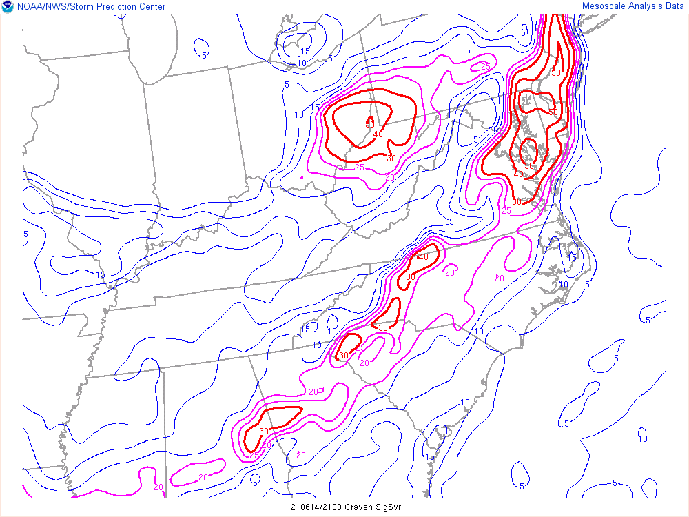
-
2021 Mid-Atlantic Severe Weather - General Discussion
Kmlwx replied to Kmlwx's topic in Mid Atlantic
One thing I'm not sure I like seeing so close to the metro areas - is GAI's dewpoint has dropped to 57. Even CGS is down to 59. The immediate DC stations like DCA, ADW etc are still in the 60s, though. My (potentially not the greatest) sensor here in Colesville has gone from the mid-upper 60s down to 61.7 for the dew. We'll ideally need to advect some of the higher dewpoint air back in for my liking. I don't think we are going to get it done with 50s dews. That potentially could be why some of the CAM runs have shown the activity really getting going only once east of I-95. Could be a little razor thin margin for those in places like MoCo and western half of Howard. -
2021 Mid-Atlantic Severe Weather - General Discussion
Kmlwx replied to Kmlwx's topic in Mid Atlantic
Severe T'storm Watch for western portions of the area. It seems to be less frequently as of the past few years for them to segment the area in events like this. Perhaps a more strongly worded watch for us later if the trends continue towards a decent severe event? The probs on the watches so far have bene pretty low. -
2021 Mid-Atlantic Severe Weather - General Discussion
Kmlwx replied to Kmlwx's topic in Mid Atlantic
18z HRRR might be a smidge earlier again - but it's tiny adjustments at this point. -
2021 Mid-Atlantic Severe Weather - General Discussion
Kmlwx replied to Kmlwx's topic in Mid Atlantic
Could be a bit later given the timing even. Nighttime severe should make for a heck of a lightshow! -
2021 Mid-Atlantic Severe Weather - General Discussion
Kmlwx replied to Kmlwx's topic in Mid Atlantic
17z HRRR looks to focus the threat around Baltimore proper. Kind of amazing how far NWP has come. The complex has mostly been shifting around like a 50 mile or less range in placement. -
2021 Mid-Atlantic Severe Weather - General Discussion
Kmlwx replied to Kmlwx's topic in Mid Atlantic
Can't be mad at this map....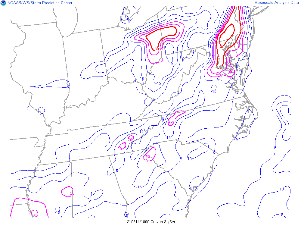
-
2021 Mid-Atlantic Severe Weather - General Discussion
Kmlwx replied to Kmlwx's topic in Mid Atlantic
I remember we went through a stretch after 2012 when everyone was calling every line of storms a derecho. That got old quicker than TWC naming winter storms! -
2021 Mid-Atlantic Severe Weather - General Discussion
Kmlwx replied to Kmlwx's topic in Mid Atlantic
Nope. That's just a line of storms. Perhaps it may become a QLCS. -
2021 Mid-Atlantic Severe Weather - General Discussion
Kmlwx replied to Kmlwx's topic in Mid Atlantic
https://www.spc.noaa.gov/products/md/md0965.html -
2021 Mid-Atlantic Severe Weather - General Discussion
Kmlwx replied to Kmlwx's topic in Mid Atlantic
No real changes to the 1630z SPC update. -
2021 Mid-Atlantic Severe Weather - General Discussion
Kmlwx replied to Kmlwx's topic in Mid Atlantic
Same general timeframe on that HRRR run - maybe more like 2z-3z for you. It looks like cells pop ahead of the original complex. -
2021 Mid-Atlantic Severe Weather - General Discussion
Kmlwx replied to Kmlwx's topic in Mid Atlantic
Latest HRRR might have even sped it up again. Has cells breaking out ahead of the complex during the 1-2z timeframe. -
2021 Mid-Atlantic Severe Weather - General Discussion
Kmlwx replied to Kmlwx's topic in Mid Atlantic
Noticed this as well. Looks decent. If we can nudge the timing even another hour or so earlier, I'll feel even better. Could be a fun night for lightning pictures. -
2021 Mid-Atlantic Severe Weather - General Discussion
Kmlwx replied to Kmlwx's topic in Mid Atlantic
The new 12z run of the NAM nest is perhaps an hour or so faster. If we add in that storms tend to clear the area faster than expected in most cases - that could bode well. Still bad timing - but a touch better. -
2021 Atlantic Hurricane Season Tracking Thread
Kmlwx replied to WxWatcher007's topic in Mid Atlantic
Some of those tracks (if the low is still decently discernable) could be good for a tropical remnant TOR threat as well. Would be fun to see both the severe and tropical threads be hot at the same time.


