

Kmlwx
-
Posts
13,549 -
Joined
-
Last visited
Content Type
Profiles
Blogs
Forums
American Weather
Media Demo
Store
Gallery
Everything posted by Kmlwx
-

2021 Mid-Atlantic Severe Weather - General Discussion
Kmlwx replied to Kmlwx's topic in Mid Atlantic
I seem to remember a few sporadic severe days in our area over the years that had them really using ominous language for a rather "standard" event. -
2021 Mid-Atlantic Severe Weather - General Discussion
Kmlwx replied to Kmlwx's topic in Mid Atlantic
The UH tracks EJ was talking about are focused down in the favored area for TORs. One of the area's mini tornado alleys. -
2021 Mid-Atlantic Severe Weather - General Discussion
Kmlwx replied to Kmlwx's topic in Mid Atlantic
Let it be known - EJ is predicting wedges over the metro area. SPC just has us in general thunder - so we have that going for us for Friday as well... -
2021 Mid-Atlantic Severe Weather - General Discussion
Kmlwx replied to Kmlwx's topic in Mid Atlantic
I'd be willing to endure 100 degree + 70+ dew weather if it meant we got a legit shot at some area-wide severe to track. -
2021 Mid-Atlantic Severe Weather - General Discussion
Kmlwx replied to Kmlwx's topic in Mid Atlantic
And it's probably wrong too. -
2021 Mid-Atlantic Severe Weather - General Discussion
Kmlwx replied to Kmlwx's topic in Mid Atlantic
That NAM nest run is better for Friday than Thursday -
2021 Mid-Atlantic Severe Weather - General Discussion
Kmlwx replied to Kmlwx's topic in Mid Atlantic
The NAM nest is so bad for tomorrow. It would be a close the blinds day. -
2021 Mid-Atlantic Severe Weather - General Discussion
Kmlwx replied to Kmlwx's topic in Mid Atlantic
Agreed for the most part. I think there's a few ways we can score still - 1) Super high heat, ring of fire ridge type derecho event (June 2012 esque) 2) A high instability day where a lone cell or two can really blow up and cause a stripe of hail/very damaging wind (but large enough to not be considered super isolated) I'm holding out hope that we can get a strong front still at some point with some sort of EML type airmass and having the warm front nearby but north of us. That's very wishful thinking though. We are probably into summer pulse season for the most part. -
2021 Atlantic Hurricane Season Tracking Thread
Kmlwx replied to WxWatcher007's topic in Mid Atlantic
And naturally, it completely vaporizes even before precip gets to DC for the most part - would not be shocking to see that happen. -
2021 Mid-Atlantic Severe Weather - General Discussion
Kmlwx replied to Kmlwx's topic in Mid Atlantic
There seems to be a lot of junk around to muddy things up earlier in the day. My guess is somewhere gets a severe report or two - but we'll keep waiting for our uber-outbreak. -
2021 Mid-Atlantic Severe Weather - General Discussion
Kmlwx replied to Kmlwx's topic in Mid Atlantic
There's enough for Thursday that still looks semi-ok that I'm still watching. I don't think anybody should be expecting a higher end event, though. -
2021 Mid-Atlantic Severe Weather - General Discussion
Kmlwx replied to Kmlwx's topic in Mid Atlantic
FWIW - The 12z run of CIPS got pretty nice looking at the 60hr mark.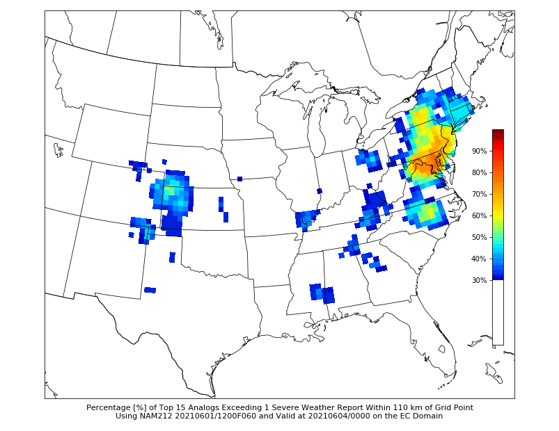
-
2021 Mid-Atlantic Severe Weather - General Discussion
Kmlwx replied to Kmlwx's topic in Mid Atlantic
That was a heck of a day. Talk about a DC area special. Little baby moderate just for our area. Always hard to believe that event and the derecho were within a calendar month of each other. -
2021 Mid-Atlantic Severe Weather - General Discussion
Kmlwx replied to Kmlwx's topic in Mid Atlantic
Out at Day 3 I won't say any fat lady has sung yet. I'm just longing for some actual severe tracking. We've had some interesting sneaky days this year so far - but so far not a ton of the big time area-wide "meat and potatoes" type events. By years elapsed only - we are due for a derecho I think. Maybe we can sneak in an ENH or MOD at some point. Hopefully we are not stuck "punting" until tropical season. -
2021 Mid-Atlantic Severe Weather - General Discussion
Kmlwx replied to Kmlwx's topic in Mid Atlantic
Wouldn't be surprising at all. One of the more common ways for us to fail. Morning junk! -
2021 Mid-Atlantic Severe Weather - General Discussion
Kmlwx replied to Kmlwx's topic in Mid Atlantic
The NAM nest has some respectable parameters too it seems. Will be interesting to see trends as we get closer. Would be fun to have a higher end slight or enhanced style event. -
2021 Mid-Atlantic Severe Weather - General Discussion
Kmlwx replied to Kmlwx's topic in Mid Atlantic
Day 3 slights often turn to Day 1 mehs around here. -
2021 Mid-Atlantic Severe Weather - General Discussion
Kmlwx replied to Kmlwx's topic in Mid Atlantic
CIPS would support something around that time. The 120hr panel is lit up decently. -
2021 Mid-Atlantic Severe Weather - General Discussion
Kmlwx replied to Kmlwx's topic in Mid Atlantic
This was the 15z surface map. Not today, folks. I'll be back watching CIPS.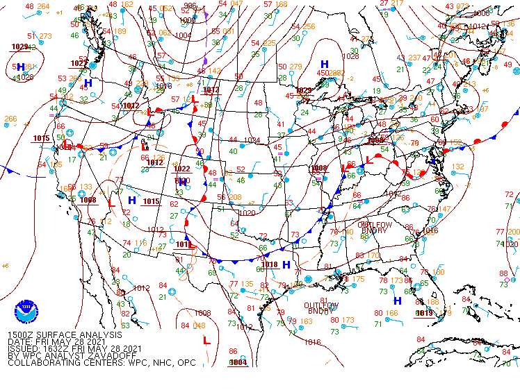
-
2021 Mid-Atlantic Severe Weather - General Discussion
Kmlwx replied to Kmlwx's topic in Mid Atlantic
Honestly - based on wind obs - the front is likely all the way down in central or southern VA still. Louisa, VA area still showing NE winds. -
2021 Mid-Atlantic Severe Weather - General Discussion
Kmlwx replied to Kmlwx's topic in Mid Atlantic
After some sun earlier this morning - it's been pretty overcast since. Was able to get the lawn mowed - it doesn't "feel" like severe today. -
2021 Mid-Atlantic Severe Weather - General Discussion
Kmlwx replied to Kmlwx's topic in Mid Atlantic
Wind direction is usually a good indicator. Winds look like they are out of the ENE in most of Maryland. Would seem to indicate the warm front isn't there yet. I've had some sun already in the Colesville, MD area. We've seem some cases in the past where even areas just north of the front can get action if something anchors along the front. Today is far from a guarantee on anything for anybody. But I'd definitely want to be south of DC as everyone has been mentioning. Southern MD and the Spotsylvania area might be a good place to be for action. -
2021 Mid-Atlantic Severe Weather - General Discussion
Kmlwx replied to Kmlwx's topic in Mid Atlantic
Any time we are looking at a warm front - it's always a game of inches. If the warm front blasts through we get warm sectored - but lose the nice wind profiles...but if it stays south we stay socked in. -
2021 Mid-Atlantic Severe Weather - General Discussion
Kmlwx replied to Kmlwx's topic in Mid Atlantic
That new hi-res FV3 model on TT looks good for tomorrow - too bad it's almost alone - along with the ARW. -
2021 Mid-Atlantic Severe Weather - General Discussion
Kmlwx replied to Kmlwx's topic in Mid Atlantic
Slight risk for tomorrow.


