

Kmlwx
-
Posts
13,552 -
Joined
-
Last visited
Content Type
Profiles
Blogs
Forums
American Weather
Media Demo
Store
Gallery
Everything posted by Kmlwx
-

2021 Mid-Atlantic Severe Weather - General Discussion
Kmlwx replied to Kmlwx's topic in Mid Atlantic
The ARW and NMMs have both been super paltry on sim reflectivity for multiple runs now. There was really only one long range HRRR run and one NAM nest run that got good storms into the area. Meh. -
2021 Mid-Atlantic Severe Weather - General Discussion
Kmlwx replied to Kmlwx's topic in Mid Atlantic
There's the marginal risk for tomorrow on the 1730z update. -
2021 Mid-Atlantic Severe Weather - General Discussion
Kmlwx replied to Kmlwx's topic in Mid Atlantic
Long range 6z HRRR looked pretty good, actually lol. -
2021 Mid-Atlantic Severe Weather - General Discussion
Kmlwx replied to Kmlwx's topic in Mid Atlantic
LOTS of thunder with this stuff. Long, rolling stuff too. Not bad for a day I expected to yield nothing. -
Predator satiation theory as well. Fascinating - albeit kind of creepy looking creatures.
-
2021 Mid-Atlantic Severe Weather - General Discussion
Kmlwx replied to Kmlwx's topic in Mid Atlantic
Something can always sneak up on us (just like snow in winter) but nothing "big" is showing up at this point. CIPS extended analogs don't show any signal for our region either. Late April is probably what we are looking at for now - or even early May. That's not atypical either. La Plata 2002 wasn't until late April. Still early for us. -
2021 Mid-Atlantic Severe Weather - General Discussion
Kmlwx replied to Kmlwx's topic in Mid Atlantic
GFS is pretty lackluster on parameters. We'll see. -
2007 had the major glacier sleetbomb. That was VDay 2007.
-
2021 Mid-Atlantic Severe Weather - General Discussion
Kmlwx replied to Kmlwx's topic in Mid Atlantic
Huge swath of the country is lit up on the extended CIPS analogs from last night's 0z runs for the 168hr timeframe. -
2021 Mid-Atlantic Severe Weather - General Discussion
Kmlwx replied to Kmlwx's topic in Mid Atlantic
Looks like we'll be waiting longer for a legit threat. CIPS isn't enthused on anything really on the extended analogs. Something could sneak up, of course. -
2021 Mid-Atlantic Severe Weather - General Discussion
Kmlwx replied to Kmlwx's topic in Mid Atlantic
NWS wasn't kidding when they said "low topped" and "shallow" - echo tops are completely unimpressive. -
2021 Mid-Atlantic Severe Weather - General Discussion
Kmlwx replied to Kmlwx's topic in Mid Atlantic
The watch probs are very low. -
2021 Mid-Atlantic Severe Weather - General Discussion
Kmlwx replied to Kmlwx's topic in Mid Atlantic
I find it semi humorous that the strongest part of the line is in the northern parts of the area - farthest away from the ENH risk to the south and east. Rest of the line looks paltry for now. -
2021 Mid-Atlantic Severe Weather - General Discussion
Kmlwx replied to Kmlwx's topic in Mid Atlantic
We'll see how these storms do as they roll off the higher terrain. -
2021 Mid-Atlantic Severe Weather - General Discussion
Kmlwx replied to Kmlwx's topic in Mid Atlantic
Looks like LWX is going with the huge polygons for warnings this PM. -
2021 Mid-Atlantic Severe Weather - General Discussion
Kmlwx replied to Kmlwx's topic in Mid Atlantic
It looks like a fair amount of areas will see at least a few peaks of sun based on the visible satellite trends. How long those peaks last remains to be seen - but of course...the more sun the higher the chances of storms is. -
2021 Mid-Atlantic Severe Weather - General Discussion
Kmlwx replied to Kmlwx's topic in Mid Atlantic
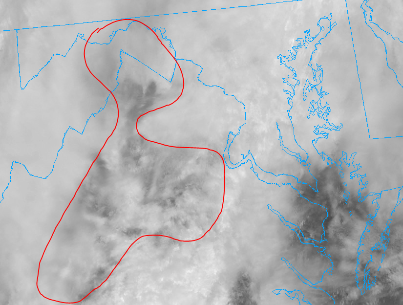
-
2021 Mid-Atlantic Severe Weather - General Discussion
Kmlwx replied to Kmlwx's topic in Mid Atlantic
Visible satellite does seem to show a some breaks in the clouds to the south and west in the mountains. I question whether that will actually make any progress into the metro area, though. -
2021 Mid-Atlantic Severe Weather - General Discussion
Kmlwx replied to Kmlwx's topic in Mid Atlantic
I'm not enthused on Today. It could be a garden variety thunderstorm day. Like I've been saying - still super early for the meat and potatoes stuff. -
2021 Mid-Atlantic Severe Weather - General Discussion
Kmlwx replied to Kmlwx's topic in Mid Atlantic
If this bias applies tomorrow - the entire subforum would be out of the game -
2021 Mid-Atlantic Severe Weather - General Discussion
Kmlwx replied to Kmlwx's topic in Mid Atlantic
The GFS has pretty paltry CAPE values for most of the metro area. The NAM looks pretty meh as well - but the NAM nest does send a healthy line through. If it were me at the SPC desk (thank god it isn't) I'd probably trim the hatched area to remove DC proper. Severe weenies near Fredericksburg are seemingly better positioned. -
2021 Mid-Atlantic Severe Weather - General Discussion
Kmlwx replied to Kmlwx's topic in Mid Atlantic
Latest guidance seems to want to get the best activity to the south and east of the DC area. Not surprising - and certainly inline with the overall SPC outlook area. NAM and the nest don't look quite as impressive as they did for the immediate metro area as they did yesterday. -
2021 Mid-Atlantic Severe Weather - General Discussion
Kmlwx replied to Kmlwx's topic in Mid Atlantic
People start paying attention when you pop in. -
2021 Mid-Atlantic Severe Weather - General Discussion
Kmlwx replied to Kmlwx's topic in Mid Atlantic
18z NAM continues to look decent for Sunday. It does look slightly less robust in a few regards - but really it's noise. Seems the potential is still solidly on the table. -
2021 Mid-Atlantic Severe Weather - General Discussion
Kmlwx replied to Kmlwx's topic in Mid Atlantic
LWX mentions next Wednesday as another potential strong thunderstorm threat - but says it could be more of a high shear/low CAPE kind of setup due to timing and limited warm air advection.


