

Kmlwx
-
Posts
13,552 -
Joined
-
Last visited
Content Type
Profiles
Blogs
Forums
American Weather
Media Demo
Store
Gallery
Everything posted by Kmlwx
-
DC area drivers suck - But tell me this - would you rather have DC drivers in a minor to moderate blanket of snow - or DC drivers in a covering of sleet and a glaze of ZR (slop). I'll take the snow...and of course even then it would suck. Hell...throw 3 melting snowflakes onto somebody's windshield on 270 and you'll end up with the entire road being closed for 3+ hours.
-

Feb Long Range Discussion (Day 3 and beyond) - MERGED
Kmlwx replied to WinterWxLuvr's topic in Mid Atlantic
I was way too lazy to do this. Also - just realized that @stormtracker - came in after I posted and said his idea of slop is different than mine. Oops. -
Feb Long Range Discussion (Day 3 and beyond) - MERGED
Kmlwx replied to WinterWxLuvr's topic in Mid Atlantic
Randy will make us move this to banter at some point, I'm sure BUT - I'd argue sleet can be much more impactful if it's really coming down. Little ice pellets take a bit longer to melt than a flakey piece of snow. If it truly is pouring sleet, that can form a crusty covering that would be a lot more awful to drive on than a covering of snow. Add in some FZRA to an untreated road or a bridge/overpass and it's a nightmare. Again - slopfest doesn't mean low impact. White rain perhaps does...but not slopfest. If it's dumping sleet I assure you it will not be wet roads everywhere. (edited for spelling) -
Feb Long Range Discussion (Day 3 and beyond) - MERGED
Kmlwx replied to WinterWxLuvr's topic in Mid Atlantic
I try to give everyone the benefit of the doubt - my therapist hasn't quite gotten that part dealt with yet @EHoffman - one thing you've gotta realize....you can't just add the word "climo" into every post and expect it to hold meteorological weight. Yes - DCA climo is warmer than suburbs - but the tarmac at DCA is not the same as NW DC. -
Feb Long Range Discussion (Day 3 and beyond) - MERGED
Kmlwx replied to WinterWxLuvr's topic in Mid Atlantic
I might be remembering wrong - but didn't you actually call for just wet roads and pretty much very low impact in DC? A slopfest is definitely not the same and can be rather high impact. To me...a slopfest is a mixed bag of precip - but doesn't mean low impact. You also said you thought all the models (except the NAM) were going to bust too cold. -
2021 Mid-Atlantic Severe Weather - General Discussion
Kmlwx replied to Kmlwx's topic in Mid Atlantic
The way I read that is that you're calling for a wedge at my place tonight in Arundel Mills. Lezdoit. -
Feb Long Range Discussion (Day 3 and beyond) - MERGED
Kmlwx replied to WinterWxLuvr's topic in Mid Atlantic
Generally speaking I AGREE with you. But your writing off of a non-marginal surface temp event as if it's a 33 and white rain event is kind of puzzling. BUT - at least you then backed it up with saying you thought the models were too cold. So I'm not battling you here - we are allowed to have different opinions. That said - the "climo" of NW DC is NOT at all the same as the tarmac at DCA. Ice storms are rare for the entire area - not just downtown Washington. Look how narrow the corridor of sig ice (significant enough to do extensive power outage stuff) was in this past event. It wasn't narrow because of DC climo - it was narrow because the areas where FZRA falls and matches up really well with the rest of the factors is always relatively narrow. Conservative is always good for DC snow. But you're also writing off the mixed nature of the event as well. I think it's totally possible the warm nose is closer to the NAM and we get sleeted to hell. But sleet can be even more impactful than snow. I'm not sold on "meh wet roads" I remember you back on Eastern - always thought you were a solid poster if memory is correct. I don't think you're not now - but you just went perhaps too far in the "meh we are DC" direction. Sometimes we've gotta actually forecast! -
Feb Long Range Discussion (Day 3 and beyond) - MERGED
Kmlwx replied to WinterWxLuvr's topic in Mid Atlantic
Power outages are not the only metric. I heard plenty of reports of accidents that were definitely above the normal background from just wet pavement. Bridges and overpasses can get ugly fast even with marginal temps. But yes - power outages were minimal in Maryland. At my place near Arundel Mills (E of the fall line!) I had to clear off like 0.3 inch of ice from my entire car. Sure - the roads weren't terrible - but they were also salted about 4 times during the icing event. Nobody is going to argue with you that DC has a UHI and it DOES impact marginal events. We'll have to see what the surface temps actually end up being for the upcoming event. -
Feb Long Range Discussion (Day 3 and beyond) - MERGED
Kmlwx replied to WinterWxLuvr's topic in Mid Atlantic
IIRC there were more than one or two posters in DC proper reporting icing that was a bit more than what most people would call a snoozer. I get your overall point - and to an extent I do agree with you. Could easily fail in the way you are suggesting - but the "heat island" of DC is smaller than the entire city in most cases. Think about how much better NW does versus near the airport. The NAM is worth looking at for the reasons PSU has pointed out. But you aren't backing up your posts with evidence like he is. Come on...at least add to the discussion...It's not hard to post something other than "NAM has done well" -
Feb Long Range Discussion (Day 3 and beyond) - MERGED
Kmlwx replied to WinterWxLuvr's topic in Mid Atlantic
I will say this - with regards to @EHoffman's comments. If the surface is 31-32 I would of course agree with him more. But if we are in the mid 20s at onset that wedge is going to be stubborn. Again, the warm layer is well above the surface. Low 30s probably means a wet event for DC. Mid 20s and there will be at least SOME trouble with ice. Remains to be seen as well how much of the stuff after any snow falls as sleet vs ZR. -
Feb Long Range Discussion (Day 3 and beyond) - MERGED
Kmlwx replied to WinterWxLuvr's topic in Mid Atlantic
I honestly am inclined to think there could be an icing threat even south of DC. Again, it'll be a narrow stripe as FRZA always is. I'm not confident (yet) that UHI is going to save you from staying frozen for longer than you're expecting. We'll see - still several days out - but just because you're in DC doesn't preclude you from a winter wx threat with this one. Even places like Fredericksburg could still be in the game for icing or sleet. -
Feb Long Range Discussion (Day 3 and beyond) - MERGED
Kmlwx replied to WinterWxLuvr's topic in Mid Atlantic
See ya next time then! It will probably be semi-significant icing somewhere in the region - that stripe remains to be seen. Low level cold air will be typically tough to scour out. I don't think this is a written off "quickly to rain" scenario for many areas. The warm layer is upstairs - not at the surface. -
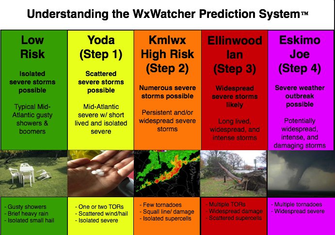
We got the thread started in January last year. Still tracking winter threats...but before you know it, @yoda will be copy/pasting severe t'storm warnings, @high risk will bring out the optimist in all of us when it looks like a marginal event is on the horizon and we'll probably fail 8 out of 10 times as usual. Memories of past severe events, pattern discussion and other general severe discussion can go in here. To get things started off - I just took a look at the CFS monthly on the TropicalTidbits site and it does seem to show a potentially nice severe pattern (if my weenie eyes are correct, that is) for June of this year. Perhaps some ring of fire type stuff with a decent ridge centered over the Dakotas area. Would think if that were to come true we'd stand a threat for MCS type stuff progressing down the ride of the ridge towards us. Of course...it's the CFS...and it's months away. Sooner or later our winter threats will dry up and we'll be tracking our first pencil thin low topped squall line. Might as well get started now... And for the sake of getting things off on a good note - here's the official @WxWatcher007 chart.
-
Feb Long Range Discussion (Day 3 and beyond) - MERGED
Kmlwx replied to WinterWxLuvr's topic in Mid Atlantic
Are you going to post every panel....? -
Have had no ice accretion on trees thus far near Arundel Mills - but now starting to see some. Looks like a tiny bit of sleet but mainly ZR. Roads just wet with ponding.
-
Shouldn't you of all people be able to fix the moisture issue? I mean....it's in your username Back on topic - it does seem a good chunk of the area will be pretty slick Sat PM to Sun AM.
-
A quarter inch of ice isn't that uncommon actually. An isolated power outage would be possible. You really don't start getting "crippling" damage until you're above a half inch of ice. Truly severe ice storms approach or exceed the 1 inch mark. Even a tenth of an inch though can cause mayhem on the roads if cold enough. Otherwise - .1-.25 ice is usually just pretty up in the trees. Usually...not always.
-
Feb Long Range Discussion (Day 3 and beyond) - MERGED
Kmlwx replied to WinterWxLuvr's topic in Mid Atlantic
I've seen between a tenth and a half inch of icing depending on what model you look at and your geographical location. -
Feb Long Range Discussion (Day 3 and beyond) - MERGED
Kmlwx replied to WinterWxLuvr's topic in Mid Atlantic
I mean...we are essentially in our prime snowstorm climo period. If the storm of the year is going to happen - might as well be in this next few weeks period. -
Give yourselves credit. At least maybe 6th or 7th grade. If you regress to fart jokes, then 5th is valid.
-
Believe he was in here during the recent long duration storm.
-
You might as well hire a camera crew and set it up like a PCH prize patrol presentation.
-
I'm efficient. Andy can be DHL when they hand off to USPS and you see the package sometime in the next decade. I'll be more like Amazon when they deliver to my house at 5:30am after I ordered an item at 10pm the night before.
-
Posted in the main thread...but this is a MUST READ RESOURCE for new members https://www.weather.gov/lwx/WarningsDefined Yes - there is some aspect of subjective decision making at the NWS - but the definitions are there.
-
I'll buy @stormtracker - a bottle of his drink of choice and be out of jail in no time


