midatlanticweather
-
Posts
4,917 -
Joined
-
Last visited
Content Type
Profiles
Blogs
Forums
American Weather
Media Demo
Store
Gallery
Everything posted by midatlanticweather
-
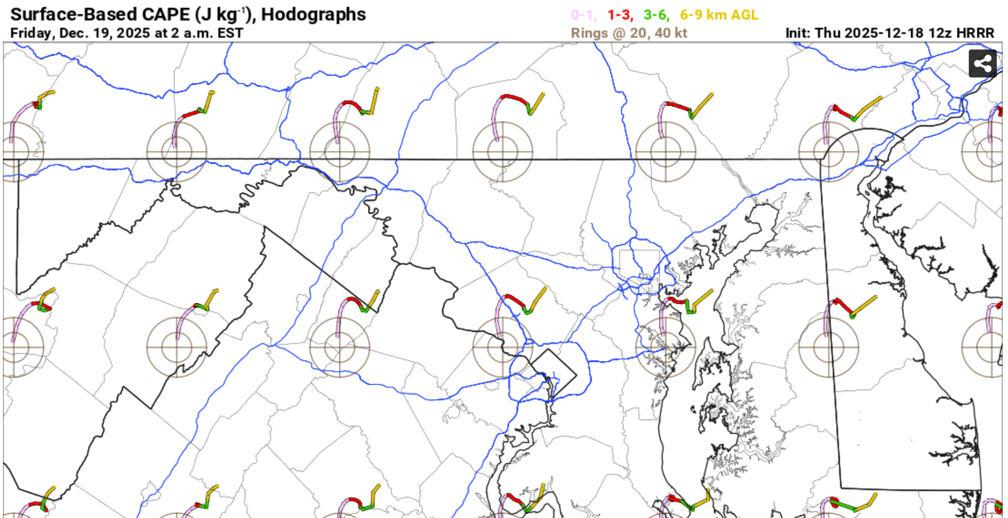
Am I right that, if there were not an inversion, and we had the right setup (like warm LOL), this would be interesting?

-

12/14: Sunday funday? Will the south win again?
midatlanticweather replied to TSSN+'s topic in Mid Atlantic
I'd the hrrr best suited for snow? It has been great having short term forecasts and seeing updates so rapidly. I have never really trusted it to be right but to help in convective setups. -
12/14: Sunday funday? Will the south win again?
midatlanticweather replied to TSSN+'s topic in Mid Atlantic
Bummed for our backyards. Suckered in by the model increases and that early burst! - Hoping January can turn the corner in the long range as Loudoun needs some good snow (And more of the DMV as well) -
12/14: Sunday funday? Will the south win again?
midatlanticweather replied to TSSN+'s topic in Mid Atlantic
This is starting to look like the end my friend. For our neck of the woods. Sucked in at the last minute by models.. Only to be left with a coating -
At least GFS keeps the cold right after Christmas. The Christmas miracle went away Things can still change (get worse -- Or better) - happy the non-stop torching does not look to be there.
-
12/14: Sunday funday? Will the south win again?
midatlanticweather replied to TSSN+'s topic in Mid Atlantic
In a lull. It kind of looks like it is drying up now to the west and north of me.. It does look pretty with the Christmas lights! -
12/14: Sunday funday? Will the south win again?
midatlanticweather replied to TSSN+'s topic in Mid Atlantic
Big snowflakes and a good amount of snow is falling. Still 32.7 degrees, so the main places with snow are grassy areas and elevated. Everything is coated now, and I walked out to slushy roads and sidewalks due to the rates. -
12/14: Sunday funday? Will the south win again?
midatlanticweather replied to TSSN+'s topic in Mid Atlantic
Steady snow now! 33/32 -
12/14: Sunday funday? Will the south win again?
midatlanticweather replied to TSSN+'s topic in Mid Atlantic
Spits an spurts of mixes rain and snow in Purcellville. Not steady yet. 35/32 -
12/14: Sunday funday? Will the south win again?
midatlanticweather replied to TSSN+'s topic in Mid Atlantic
Loudoun is slowly getting into the game for a 1-inch event, with some lollies to 2 or so. Obviously, better east than west, though elevation is starting to show help. 38.2/30 -
https://media.tenor.com/2739Fe1Wj-QAAAAM/whomp-whomp.gif
-
You know it.. Here come the comments Sign here Lock it up Give me that and call it a winter The big ones are sniffed out early. It all is coming.. Until Dr No or the next run. Lol
-
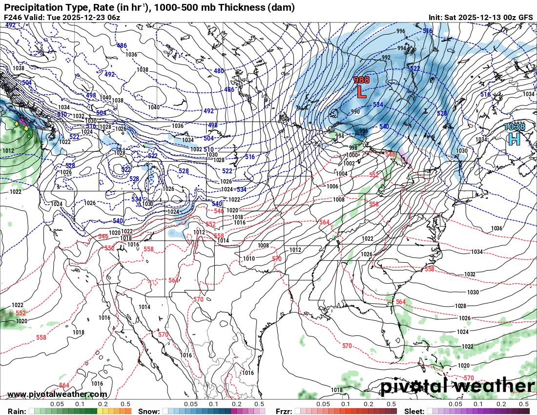
Thar she blows! What a windy looking map.
-
12/14: Sunday funday? Will the south win again?
midatlanticweather replied to TSSN+'s topic in Mid Atlantic
I am out here in Western Loudoun. It is not looking great. I am betting on fail. -
12/14: Sunday funday? Will the south win again?
midatlanticweather replied to TSSN+'s topic in Mid Atlantic
This year has been all about begging for table scraps and nosing around in the trash for even a small amount! I am hoping for crazy ratios and overperformance! I am worried I will just be choking on a bone on Sunday! LOL -
I think we are out of luck on that. Agreed the trough just is not favorable for much amplification sooner. 30:1 ratios could help. Lol
-
I would like it to get it's act together a lot quicker.. I would take anything though. We have wasted way too much cold.
-
12.4 for the low. Currently 19.
-
Richmond Metro/Hampton Roads Area Discussion
midatlanticweather replied to RIC Airport's topic in Mid Atlantic

-
I feel every La Nina we look at maps like this and they suck!
-
This is our Voldemort
-
The Return of the 12/5 Snowstorm
midatlanticweather replied to SnowenOutThere's topic in Mid Atlantic
Light snow here in purcellville -
The Return of the 12/5 Snowstorm
midatlanticweather replied to SnowenOutThere's topic in Mid Atlantic
I say we stop Kuchera maps! That is all -
The Return of the 12/5 Snowstorm
midatlanticweather replied to SnowenOutThere's topic in Mid Atlantic
Any chance for high ratios? LOL! Get every bit out of it we can squeeze! -
Sleet and a little snow here in Purcellville.