midatlanticweather
-
Posts
4,917 -
Joined
-
Last visited
Content Type
Profiles
Blogs
Forums
American Weather
Media Demo
Store
Gallery
Everything posted by midatlanticweather
-
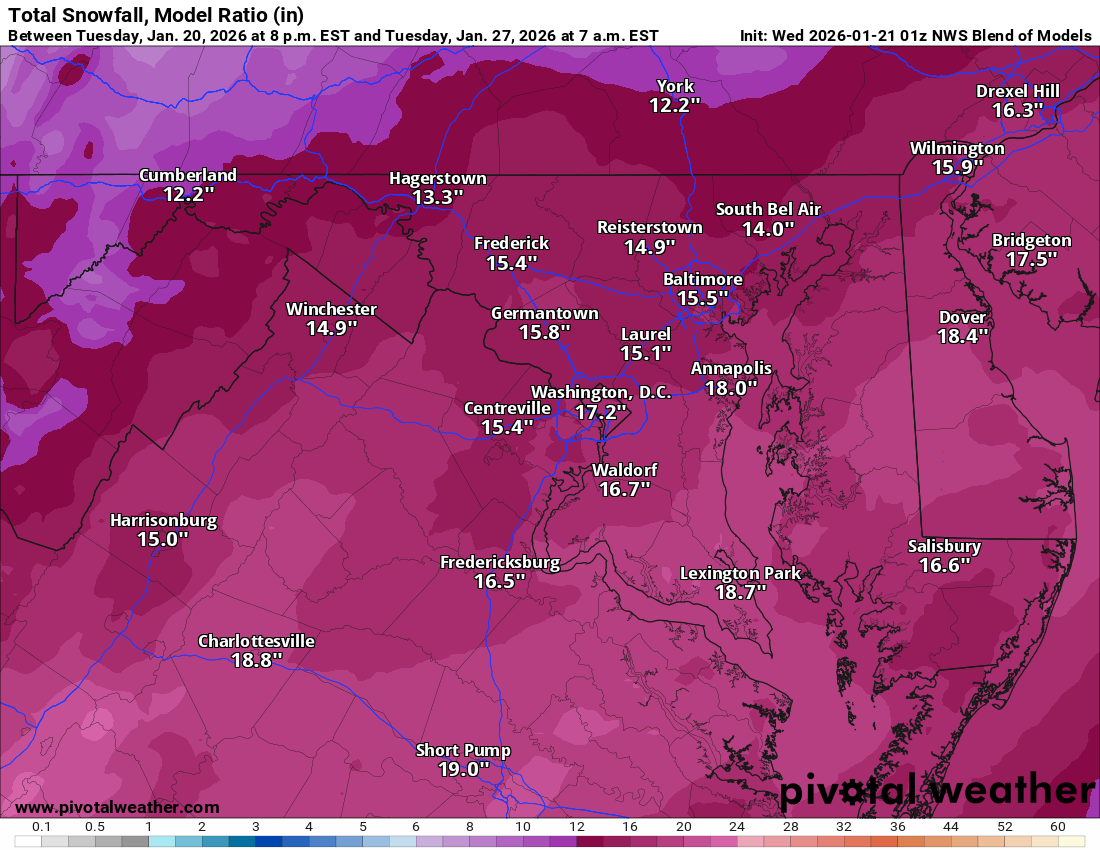
The NBM keeps ticking higher.

-
See you all in a few hours. Thanks for all you all do to make it worth returning.
-
Ya.. Gave me pd2 vibes for a moment.. The sleet mess ruined my storm in Sterling
-
The glacial outcome from the follow up cold is going to make it brutal..
-
HH brought the goods. Thanks for the pbp
-
-
There was that one GFS off run (hmmm - kind of similar!) with it south... only to turn around and bring the big stuff... MAN! Remember the radio show before that one! DT was on it when he was kind of tolerable... LOL!
-
We should have a banter threat for any one storm instead of a catch all! I LOL so many times from some of the posts... I want to hone in on them for the storm! Just saying!
-
The issue we also seem to have is that the speed of movement is missed on models. That speed = how much snow falls. They tend to be longer on the runs than in actuality (My Deb downer hat is on today!)
-
I am going to be the Debbie downer here... all season(last year) we have been seeing big precip events start drying up as the event approached... I know here we have southern system involvement, but any concerns here? We had like 1 overperformer rain event in the last year and most have been way less than forecast. Gives me pause this far out.
-
Give me 20:1 ratios and this is great.lol smoke
-
From a N stream system or a Southern stream system view in a fast moving environment, these two scenarios make sense.. and suck
-
Hit 19.7 degrees at 8PM yesterday. Coldest so far today was 20.4 degrees.
-

January 2026 Medium/Long Range Discussion
midatlanticweather replied to snowfan's topic in Mid Atlantic
Let's get some negative tilt! The western guys are hoping for more! But I am pulling for everyone.
-
January 2026 Medium/Long Range Discussion
midatlanticweather replied to snowfan's topic in Mid Atlantic
Lol.. It was not in board. It showed mild support, but was never super sold on the idea. But the euro has let us down a lot this year too.. I would be drought free and in a surplus if we got the rain it has shown. -
January 2026 Medium/Long Range Discussion
midatlanticweather replied to snowfan's topic in Mid Atlantic
Gfs was on its own from the start. Faith in models 5+ days seems a fool's chase. I am guessing we will be fooled again soon. I am not mad at the models, I am mad for believing they may be correct. -
January 2026 Medium/Long Range Discussion
midatlanticweather replied to snowfan's topic in Mid Atlantic
Here we need to be on the Northern side of a big amount of snow early, with tons of room for movement. If we are too close to the cutoffs, we can easily get missed to the north. We do not have much cushion on this one.. that vort has to dig.. We need a big dig.. BIG.. and just far enough west to turn right. If we complicate this any (as we are now) we will need to bet on fail... -
January 2026 Medium/Long Range Discussion
midatlanticweather replied to snowfan's topic in Mid Atlantic
Rare do we get perfect storm formations on our doorstep. It can happen and I think we will watch but the pessimist in me says we have to get it to the south -
So it is outstanding when out standing!
-
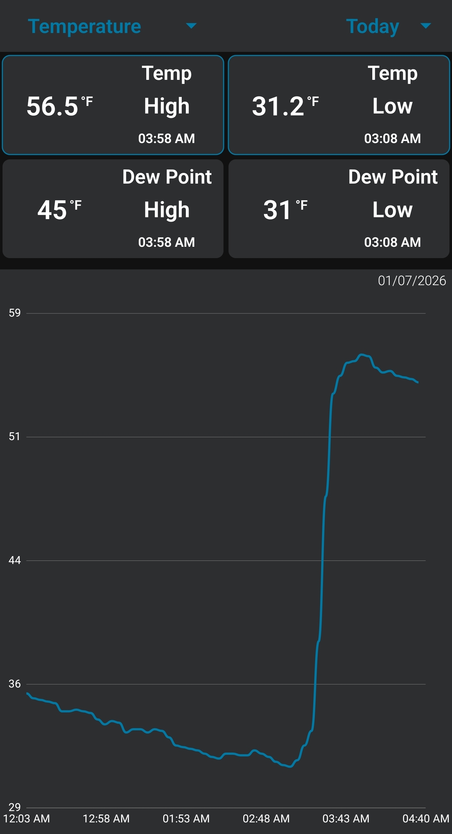
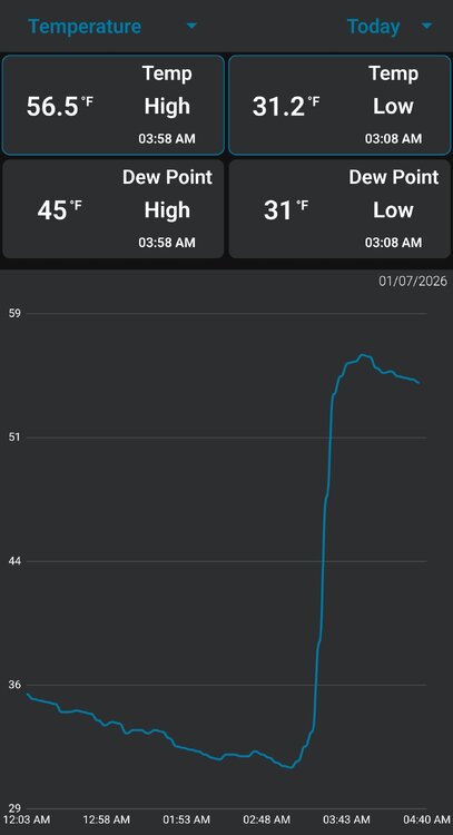
West winds did it again! Sheltered locations remain in the low to mid 30s but about an hour ago we received wnw winds that shot temps up. 55 degrees currently
-
January 2026 Medium/Long Range Discussion
midatlanticweather replied to snowfan's topic in Mid Atlantic
Set goals not resolutions!! That is all I have to share. Next few weeks look bad. Resolutions will probably end for most people before the pattern changes again. Even more before mid February. -
West winds shot the temps up!! 58 degrees. Seeing sheltered spots in the 30s nearby. Crazy stuff
-
Until tomorrow
-
At this rate, tomorrow we will be saying congratulations NC! That is a serious south trend
-
I have decorations down.. it is a massacre of lighted snowmen outside! - Hoping winds subside soon! Winds have to be gusting to 50+ at times. Lights have been going flickering and had brief outage.