midatlanticweather
-
Posts
4,901 -
Joined
-
Last visited
Content Type
Profiles
Blogs
Forums
American Weather
Media Demo
Store
Gallery
Everything posted by midatlanticweather
-
My yard is looking the same out here in Purcellville. All dried up.
-
Coolest morning so far! 49.8 degrees! Barely dipped into the 40s.. will not matter as head for the sauna!
-
Had the same low as yesterday! 53.8 degrees! Yesterday was 81, but 83 so far today!
-
Yep.. down the street from you. I luckily had more rain than you (a little more than 2 times) at 1.19 inches. but it is bad! Most saw less than an inch and all grass is brown or yellow. Trees show serious signs of stress. I am on a well and have been telling everyone to conserve in the house! I do not want a dry well. Hoping for some chances of rain that are not showing, but we do look like 10 days of dry and hot weather! Ugly
-
53.8 for a low. So nice.
-
1.19 at my house. Checked multiple stations near me and they are below an inch.
-
Not sure I am seeing things right, but it seems we had a little more North Northwestward jog based on satellite images. Anyone else see this? It is not too significant, but could have some implications!
-
This picture continues the yellow lawn! Not good! Maybe we can improve it! The return to above normal and dry weather the following week is going to start to get me more worried! We need rain!
-
Yep.. I screwed up then reposted and screwed up again. Thx.
-
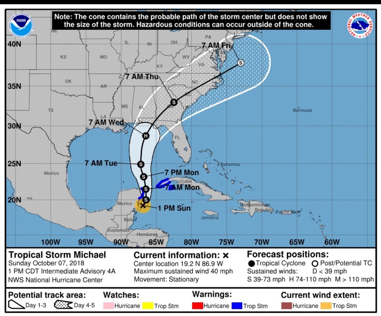
Edit: Track reminded me of Michael. Sorry! This is what it looked like.

-
If we do not get some ocean normalization, that heat could really hurt.. BUT, we get some super cold with such a contrasting sea, who knows. Speculation the last few years has been nothing but heartbreak! I have learned many other things that have failed when I felt they should not have!
-
95.7 was just shy of my highest day of 96.2. Crazy! Humidity stunk today too!
-
A little tropical history
-
53 for my low. Coolest for the season so far! Love it
-

2023 Mid-Atlantic Garden, Lawn, and Other Green Stuff Thread
midatlanticweather replied to mattie g's topic in Mid Atlantic
Still feeling the sting of drought out this way. I need to secure some seed and get aeration done. The challenge is the dry hard soil. Trajectory has not been great for good rains in Purcellville. We have improved recently but still a lot of parched soil -
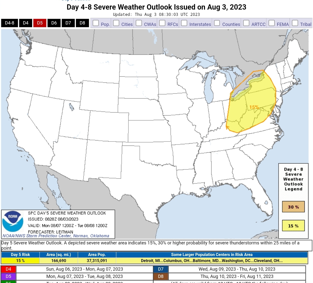
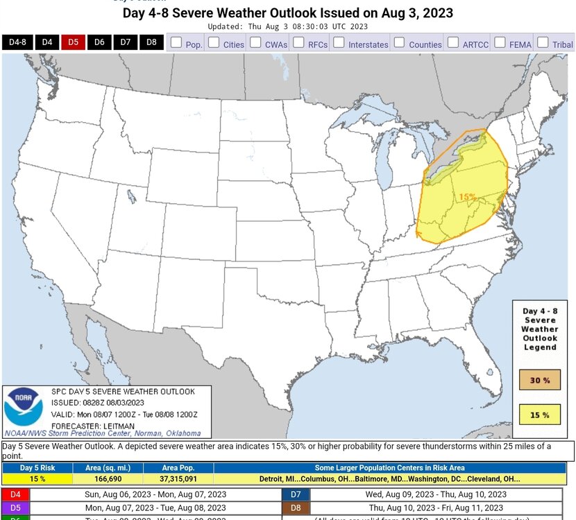
2023 Mid-Atlantic Severe Wx Thread (General Discussion)
midatlanticweather replied to Kmlwx's topic in Mid Atlantic
Oh, ya, I am not saying there weren't any. It is a lot harder to see tornadoes in our area. I would have thought there would have been a few though. Wind was always the primary threat. Rotating supercells were definitely out there in parts of the area.- 2,785 replies
-
- 1
-

-
- severe
- thunderstorms
- (and 3 more)
-
2023 Mid-Atlantic Severe Wx Thread (General Discussion)
midatlanticweather replied to Kmlwx's topic in Mid Atlantic
Interesting day yesterday. Lots of wind, many supercells, big hail, but few if any tornado reports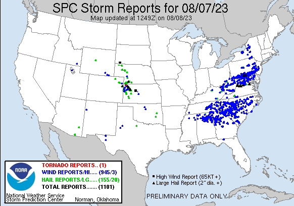
-
2023 Mid-Atlantic Severe Wx Thread (General Discussion)
midatlanticweather replied to Kmlwx's topic in Mid Atlantic
I believe it has to do with models and the small dry layer that models are advertising. This will bring the potential for hail as well as winds. Now, there are some Mets here that can be more technical than me for sure.- 2,785 replies
-
- 1
-

-
- severe
- thunderstorms
- (and 3 more)
-
2023 Mid-Atlantic Severe Wx Thread (General Discussion)
midatlanticweather replied to Kmlwx's topic in Mid Atlantic
- 2,785 replies
-
- 3
-
-
- severe
- thunderstorms
- (and 3 more)
-
Wow
-
Yesterday was my season high of 96.1 degrees. Thinking that will be it for the Summer as the clouds today are slowing the heating. Dewpoint is 71 and temp is 77. Sticky out there
-
LOL! At my home we dodged everything! I ended with a trace! Temps is way down to 79! So I am not complaining!
-
96/79 measured at 2:15pm was the worst of the day. Heat Index at that time was 114. Yuck. May be a bit high.