midatlanticweather
-
Posts
4,915 -
Joined
-
Last visited
Content Type
Profiles
Blogs
Forums
American Weather
Media Demo
Store
Gallery
Everything posted by midatlanticweather
-
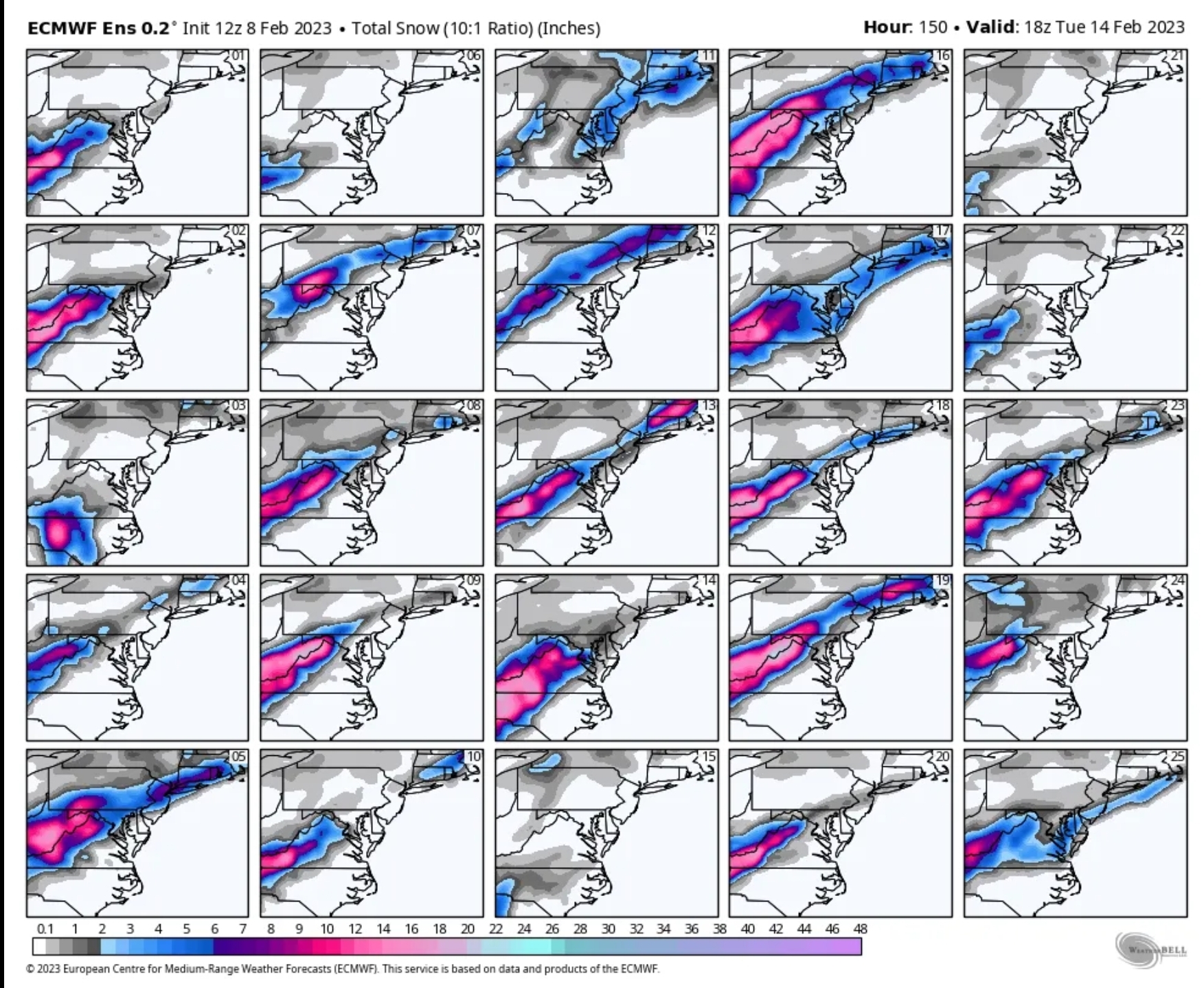
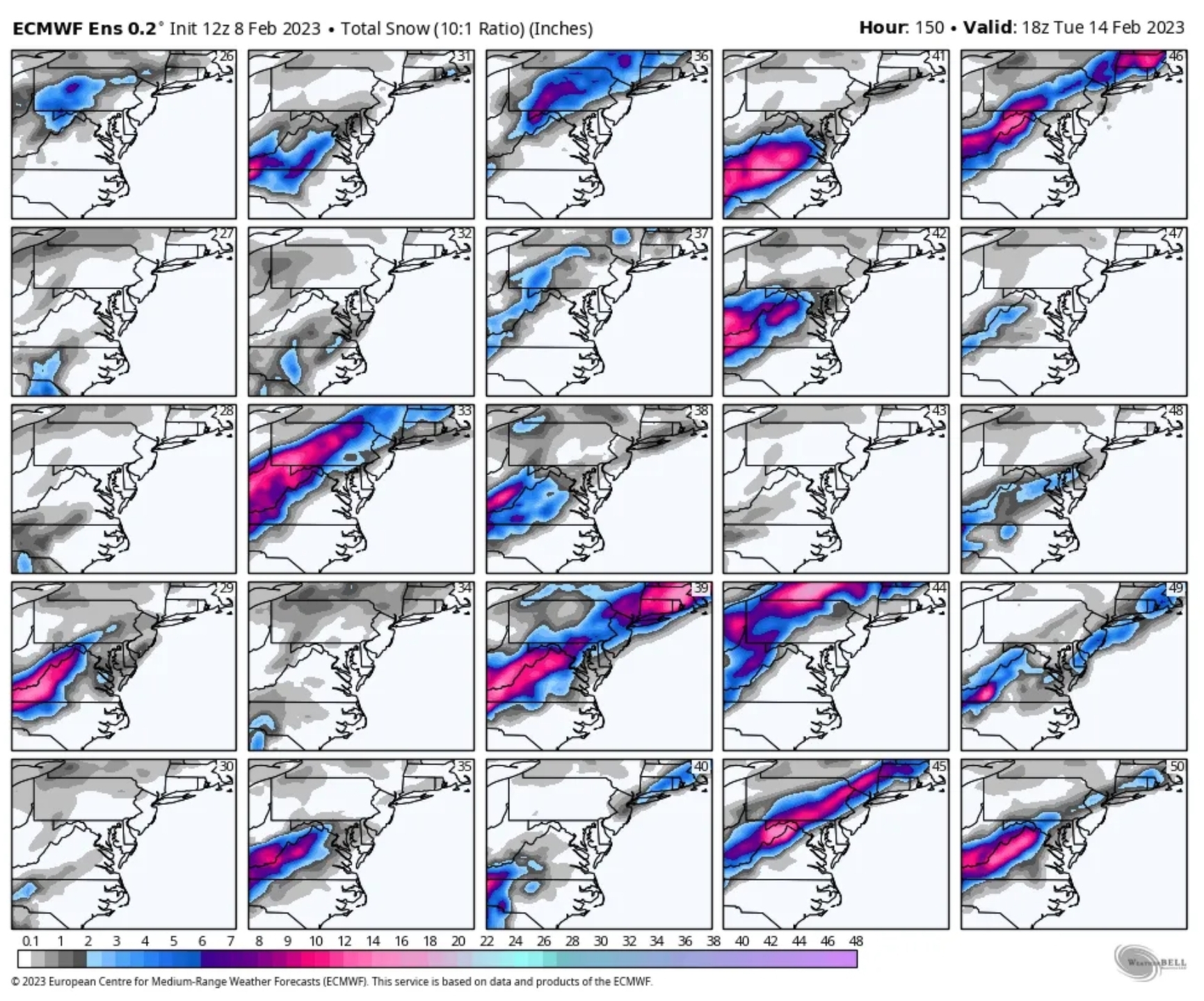
LOL! Ok! The storm thread was early! But, honestly, you would not have opened the thread and read it if you were not tracking this fail! Come on! Admit it! You are still checking every model run. The thread did not jinx anything! We all love to whine and complain, but science is science. It did not hurt a dang thing! It did clean up the longer range thread! That one slowed to a trickle. LOL! Anyways, lesson learned! My 2 cents! Majorly biased 2 cents. Please be careful if a cat crosses your path if you think the thread caused the snow to miss us.
-
 So crazy! But the NAM way out of its range.
 -
@Jiwill te you that I am the jinx maker. Every time I post things go worse. I wanted a dry Sunday so it all worked out. Your cursing is my blessing.
-
Icon was a wet bath.
-
It is not super optimistic.
-
Late February will be rocking. February Long range Discussion thread
midatlanticweather replied to Ji's topic in Mid Atlantic
Can I try this once? Kill it if you hate it! -
We are tracking something. The potential is there for a small win or complete failure, but some scoring possible. Freezers need to be left open and some crazy dynamics could be the Hail Mary that changes the game!
-
Late February will be rocking. February Long range Discussion thread
midatlanticweather replied to Ji's topic in Mid Atlantic
I think the places the mixing occurs is how the storm will end up... I would not be thinking accumulations outside higher elevations. Some mixy stuff accumulations for some that get into the deform areas, but outside the mountains, not much. That was a strange way to get there on the Euro. -
Late February will be rocking. February Long range Discussion thread
midatlanticweather replied to Ji's topic in Mid Atlantic
If I miss snow, I get upset.. but none worse than when it is south of me! - I am a child when it comes to missing snow. -
Late February will be rocking. February Long range Discussion thread
midatlanticweather replied to Ji's topic in Mid Atlantic
What the... I am just looking at the GFS! LOL - Not even close on any other parts of the set up at the time, but January 25, 2000 came to mind.. LOL! Man, this is not going to be fun if the south gets clobbered and we are missed. -
Late February will be rocking. February Long range Discussion thread
midatlanticweather replied to Ji's topic in Mid Atlantic
Pitiful set of model runs! The winter will be over soon! This winter is like pouring lemon juice on an open wound! -
Late February will be rocking. February Long range Discussion thread
midatlanticweather replied to Ji's topic in Mid Atlantic
GFS - Says - Let's do the same old GL low and not look good anymore! LOL! Lame year! -
Late February will be rocking. February Long range Discussion thread
midatlanticweather replied to Ji's topic in Mid Atlantic
Ya.. that west coast look is crappy though! Sucks! -
Late February will be rocking. February Long range Discussion thread
midatlanticweather replied to Ji's topic in Mid Atlantic
I was .. My breakfast was awesome! Finished it off with some Orange juice.. A big glass! It was a big finish! -
Late February will be rocking. February Long range Discussion thread
midatlanticweather replied to Ji's topic in Mid Atlantic
Lame memories! -
We all become manbabies when things breakdown! I am guilty as charged. I am going to avoid the forum until.... what the heck am I saying?! I will always visit quickly to see if there is something worth watching! LOL! But the meltdowns and bickering are just evidence of the condition!
-
Jan 31 - Feb 1 Snow/Sleet/Misery Obs & Disco
midatlanticweather replied to NorthArlington101's topic in Mid Atlantic

-
Jan 31 - Feb 1 Snow/Sleet/Misery Obs & Disco
midatlanticweather replied to NorthArlington101's topic in Mid Atlantic
32.2 / 31 -
Jan 31 - Feb 1 Snow/Sleet/Misery Obs & Disco
midatlanticweather replied to NorthArlington101's topic in Mid Atlantic
Little sleet and light rain were mixed briefly here. Seems the precip is going to cut off. I mean like a sleet pellet every 10 to 20 seconds.. nothing exciting at all! 37 degrees -
Jan 31 - Feb 1 Snow/Sleet/Misery Obs & Disco
midatlanticweather replied to NorthArlington101's topic in Mid Atlantic
"Victory stripe.." love that! LOL! -
January/February Mid/Long Range Disco IV: A New Hope
midatlanticweather replied to stormtracker's topic in Mid Atlantic
THE GL low is infamous! It shows up and we all hope it is a fluke.. and it may be, except when it ruins our snow hopes! -
January/February Mid/Long Range Disco IV: A New Hope
midatlanticweather replied to stormtracker's topic in Mid Atlantic
As soon as it gets complicated, we have the "too many levers to pull" as @Bob Chill mentioned before. We are not in a great spot, and, if we know anything, usually trends like this are just the beginning. I mean, maybe just one run, but seriously, the way this winter has been, it is a sign of continuation of cuts to the north and west. There is really nothing holding the cold from escaping. Perfect timing has to be the case.. odds are against it -
January/February Mid/Long Range Disco IV: A New Hope
midatlanticweather replied to stormtracker's topic in Mid Atlantic
Go back to 2013 - 2014 for trends that moved south! It was a very odd year and we just seemed to be in the right place balancing cold and the SE Ridge. Rare and unlike anything I had ever seen! -
January/February Mid/Long Range Disco IV: A New Hope
midatlanticweather replied to stormtracker's topic in Mid Atlantic
Seems to have been the story this year though! Hopes in both ensembles and the ops pretty quickly slip and then the next threat becomes the focus.. rinse, repeat. Even a blind squirrel will occasionally find a nut, I just hope we get a good one before the year is done! I appreciate the response and get it, but it seems when things start getting worse as a trend, the trend only gets worse in subsequent runs. It is not a good year down this way!