midatlanticweather
-
Posts
4,915 -
Joined
-
Last visited
Content Type
Profiles
Blogs
Forums
American Weather
Media Demo
Store
Gallery
Everything posted by midatlanticweather
-

March Medium/Long Range Discussion
midatlanticweather replied to WinterWxLuvr's topic in Mid Atlantic
Maybe it can be this time... LOL! You know it won't! -
March Medium/Long Range Discussion
midatlanticweather replied to WinterWxLuvr's topic in Mid Atlantic
Not this year! And I feel like when we lost them, they were south. -
March Medium/Long Range Discussion
midatlanticweather replied to WinterWxLuvr's topic in Mid Atlantic
I am such a downer.. but 9.5 out of 10 times, we usually see that shift north in the shorter lead times. It does happen south when we have a good block, but that just is not really there in this setup. We would need to see some evidence that the models are missing something. I do not think they are in this range. -
March Medium/Long Range Discussion
midatlanticweather replied to WinterWxLuvr's topic in Mid Atlantic
Well, I will have another week of non-distracted work again! This winter is nothing but rounds and rounds of punched below the belt! -
March Medium/Long Range Discussion
midatlanticweather replied to WinterWxLuvr's topic in Mid Atlantic
Corrections to the North and West seem typical. Corrections to the south and east are pretty rare. I am pessimistic and hope I am wrong. -
March Medium/Long Range Discussion
midatlanticweather replied to WinterWxLuvr's topic in Mid Atlantic
This may mean the Severe Thread needs some attention. -
March Medium/Long Range Discussion
midatlanticweather replied to WinterWxLuvr's topic in Mid Atlantic
Definitely seeing the shift North. We are in a bd spot on all models being just barely in the game. We need to be on the northern edge of the snow and not the southern to make me feel this is in a good spot. One or two more ticks north in the Euro and we are out. Seems almost inevitable based on this year's trends. -
March Medium/Long Range Discussion
midatlanticweather replied to WinterWxLuvr's topic in Mid Atlantic
The story of 2022-2023... This is a given! -
March Medium/Long Range Discussion
midatlanticweather replied to WinterWxLuvr's topic in Mid Atlantic
That was awesome! -
02/25 Light Snow Chance Disco/Obs
midatlanticweather replied to NorthArlington101's topic in Mid Atlantic
Nice light snow. Been moderate twice here. Temps down to 33. Shaded rooftops and mulch getting a little dust -
March Medium/Long Range Discussion
midatlanticweather replied to WinterWxLuvr's topic in Mid Atlantic

-
March Medium/Long Range Discussion
midatlanticweather replied to WinterWxLuvr's topic in Mid Atlantic
But, this is the Mid-Atlantic and not Boston! When we see the pull to the north, that rarely, if ever, trends back into a favorable look for us. Debbie Downer here will say, this is the trend of the north and west trend and it is unlikely to improve. Yes, I will look at the ensembles and always have some weenie hope, but this is a repeating theme here all the time! I HOPE I AM WRONG.. And I appreciate the optimism! -
78 was my high so far. I think that will do it.
-
76 this last hour in Purcellville. Back to 75. Will see if we can go higher!
-
Late February will be rocking. February Long range Discussion thread
midatlanticweather replied to Ji's topic in Mid Atlantic
The way you described this reminded me of that robot guy that used to put out strange forecasts with numbers and pretend he was a robot! That was some strange stuff. May have been back in Eastern wx days -
Late February will be rocking. February Long range Discussion thread
midatlanticweather replied to Ji's topic in Mid Atlantic
Despair -
Late February will be rocking. February Long range Discussion thread
midatlanticweather replied to Ji's topic in Mid Atlantic
Gfs took it away -
GFS is a great model!
-
NWS says wintry mix is likely here in Purcellville!
-
Man.. Failing again on a whole other level! Not only no snow, but no rain either. If I tell you who will win the Super Bowl you know to bet on the other team! Thread of lameness. Time to unpin!
-
What a disaster! At least the disaster is not crowding the heat wave talks we have in the long-range. This winter is one of the worst ever!
-
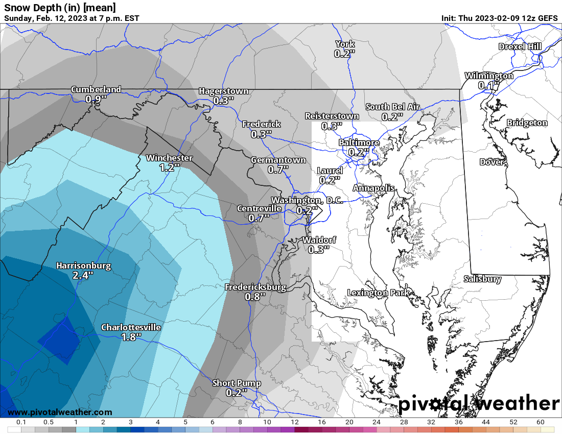
Small potatoes. But not 0" for everyone!

-
Jumped north quite a bit and snow... but we are sooooo toasty outside the mountains, as people keep saying! Still.. getting close to giving some here a little something! Another jump like that and people to the west may be a bit more involved.
-
I cooked my pizza on the cardboard that came in the packaging last week by accident! LOL! I thought I smelled something burning. Turned out alright, but I do not recommend it!