Kleimax
-
Posts
450 -
Joined
-
Last visited
Content Type
Profiles
Blogs
Forums
American Weather
Media Demo
Store
Gallery
Everything posted by Kleimax
-
CMC should take everyone off the ledge
-
DT copying Noah Bergren’s tweet lol
-
Loud thunder in Owings Mills, sounds like a summertime thunderstorm
-
Measured 3.5 inches in Owings Mills
-
Getting smoked in Owings Mills
-
Jan 19th Snow on Snow: the this always works until it doesn't thread
Kleimax replied to psuhoffman's topic in Mid Atlantic
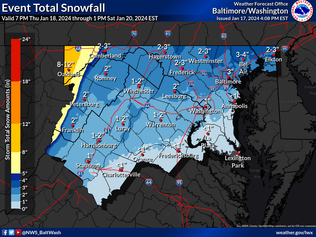
Seems like the expected snowfall map from LWX increased from this morning for northern areas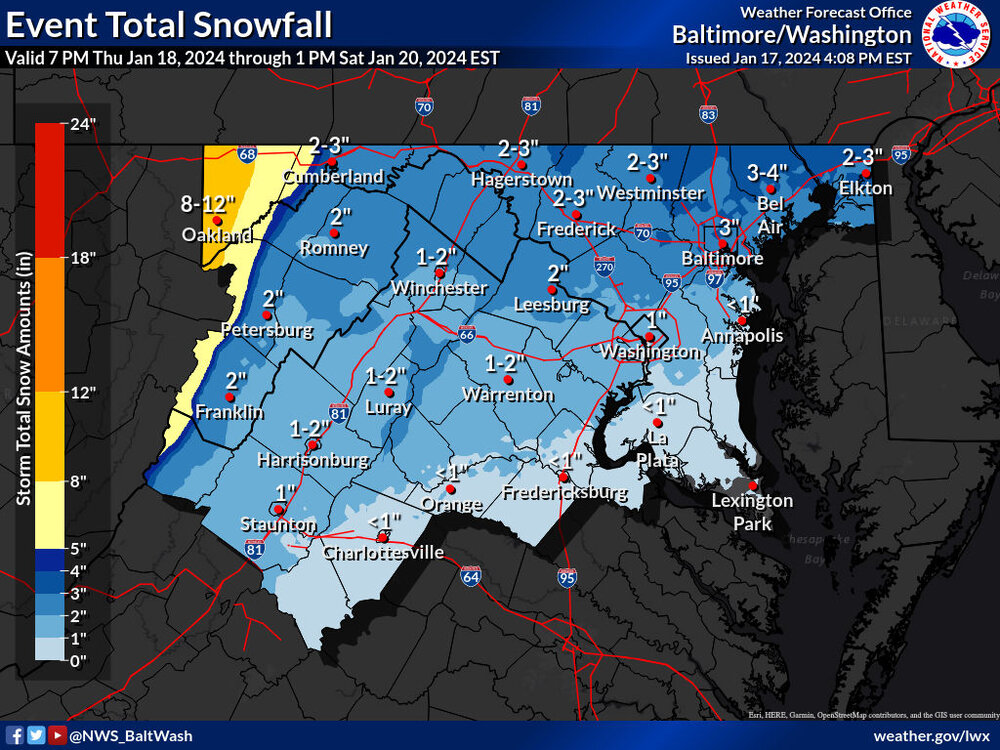
-
Very light pixie dust in Garrison
-
Jan 15-16 Storm Threat Thread: The Return of Hope??
Kleimax replied to stormtracker's topic in Mid Atlantic
Arkansas Pummeled -
All rain in Garrison
-
2023 Mid-Atlantic Severe Wx Thread (General Discussion)
Kleimax replied to Kmlwx's topic in Mid Atlantic
That cell that came through Pikesville was gnarly. Took the power out for a few seconds- 2,785 replies
-
- 1
-

-
- severe
- thunderstorms
- (and 3 more)
-
2023 Mid-Atlantic Severe Wx Thread (General Discussion)
Kleimax replied to Kmlwx's topic in Mid Atlantic
Wasn’t really that bad in Pikesville- 2,785 replies
-
- 1
-
-
- severe
- thunderstorms
- (and 3 more)
-
We can't stop losing!
-
Late February will be rocking. February Long range Discussion thread
Kleimax replied to Ji's topic in Mid Atlantic
What's the NASA model showing? -
Late February will be rocking. February Long range Discussion thread
Kleimax replied to Ji's topic in Mid Atlantic
It’s gonna cut -
Jan 31 - Feb 1 Snow/Sleet/Misery Obs & Disco
Kleimax replied to NorthArlington101's topic in Mid Atlantic
The FV3 is a little juicier -
Tony Pann is posting the 48hr HRRR. It’s happening
-
January Mid/Long Range Disco 3: The great recovery or shut the blinds?
Kleimax replied to psuhoffman's topic in Mid Atlantic
Just like that, GFS has a storm threat Jan 22-24 -
Can't believe Buffalo has no snow on the ground after the 200 inches they've received this year
-
Isn't the storm supposed to create it's own cold air or something?
-
Towson jackpot
-
It's the Tony Pann coastal low
-
Noob question here please don’t roast me, but why do the higher elevations stay colder longer? I thought “cold air sinks” and “heat rises”, so shouldn’t the lower elevations stay colder than the mountains?
-
Even Mexico gets more snow than we do
-
Severe Thunderstorm Warning for Allegany and Garrett County... Don't see that too often in Late November
-
https://www.tropicaltidbits.com/analysis/models/?model=gfs®ion=watl&pkg=mslp_pcpn&runtime=2022092500&fh=0