
Kleimax
-
Posts
451 -
Joined
-
Last visited
Content Type
Profiles
Blogs
Forums
American Weather
Media Demo
Store
Gallery
Everything posted by Kleimax
-
Seems like there’s a force field Baltimore north and west to prevent any storms from firing up
-
Was dumping in that band but it shifted west a bit
-
Yuge Flakes in Garrison / Pikesville
-
A little wind in Pikesville, Power flickered a few times. Nothing crazy
-
Looks like DT called out Jays Wintery Mix on Facebook for posting the HRDPS and referring to it as the NAM, you hate to see it @Ji
-
2.5in on top of my car in Garrison
-
 Chuck was right about everything
 -
Dry Air
-
The Jan 31 Potential: Stormtracker Failure or 'Tracker Trouncing
Kleimax replied to stormtracker's topic in Mid Atlantic
I’ve got a feeling we haven’t reached the peak yet -
Probably somewhere around 7 inches. Sleet has taken over now
-
Flake size starting to increase. Started Jebwalk around 7:50 mostly just icy little flakes, they’re starting to get a little fluffier now. Wind is def gusting and the snow is drifting a bit. Deep winter out there
-
6 inches in Pikesville/Garrison
-
Grey Rock
-
Just measured 3.75 in Pikesville
-
Jan 24-26 Weekend Snow and Sleetfest Model Thread Part Tres
Kleimax replied to H2O's topic in Mid Atlantic
The NAM 3k is the new Dr. No -
Jan 24-26 Weekend Snow and Sleetfest Model Thread Part Tres
Kleimax replied to H2O's topic in Mid Atlantic
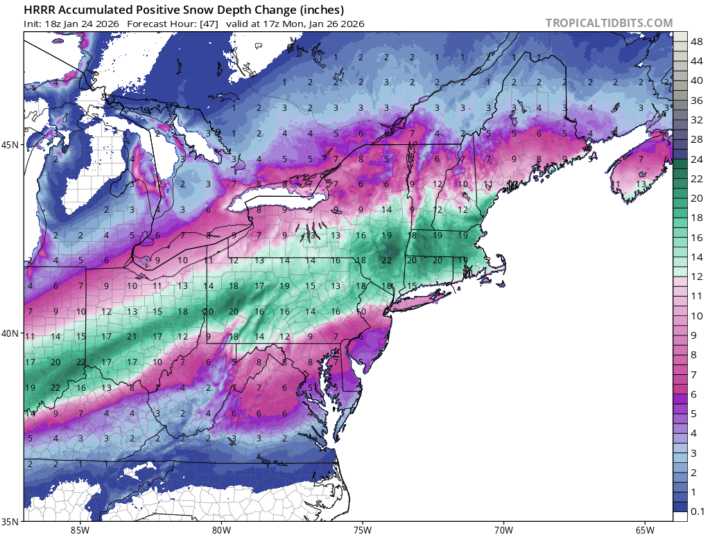
18z HRRR Snow Depth for the duration of the storm.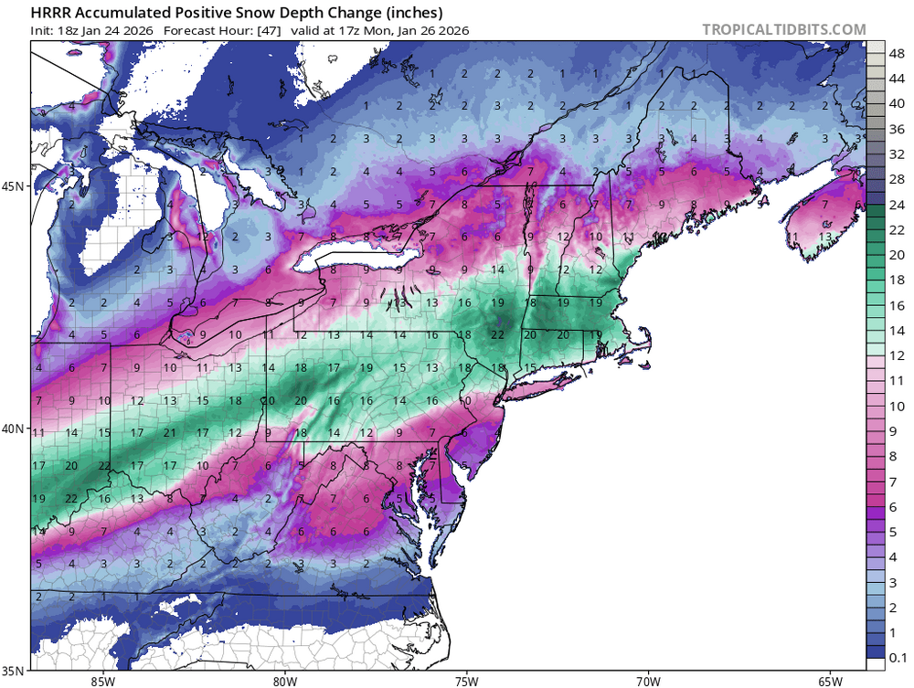
-
January 24-26: Miracle or Mirage JV/Banter Thread!
Kleimax replied to SnowenOutThere's topic in Mid Atlantic
There is an absolutely massive water main break in Towson along York & Bosley Rd. Water is going down York RD like a river. -
Anyone have the Euro 10:1 ratio? Tropical tidbits hasn’t even started running yet
-
If they left it at the left hash it might have gone in
-
0z GFS develops a hurricane at hour 384
-
That storm near Bowie / Edgewater has that look
-
Is this the type of setup where we could potentially see the timing of the onset slow down a little bit? I have a flight coming from Florida back here Thursday morning. A Wednesday night start would not be good for me.
-
Still waiting on 27 out of the 30 inches from those amazing ensemble runs from a few days ago
-
1/19 - The Roulette Wheel 29 Black Storm - OBS
Kleimax replied to DDweatherman's topic in Mid Atlantic
Seems like the NAM 3k was the closest to being right