NJwx85
-
Posts
19,714 -
Joined
-
Last visited
Content Type
Profiles
Blogs
Forums
American Weather
Media Demo
Store
Gallery
Everything posted by NJwx85
-
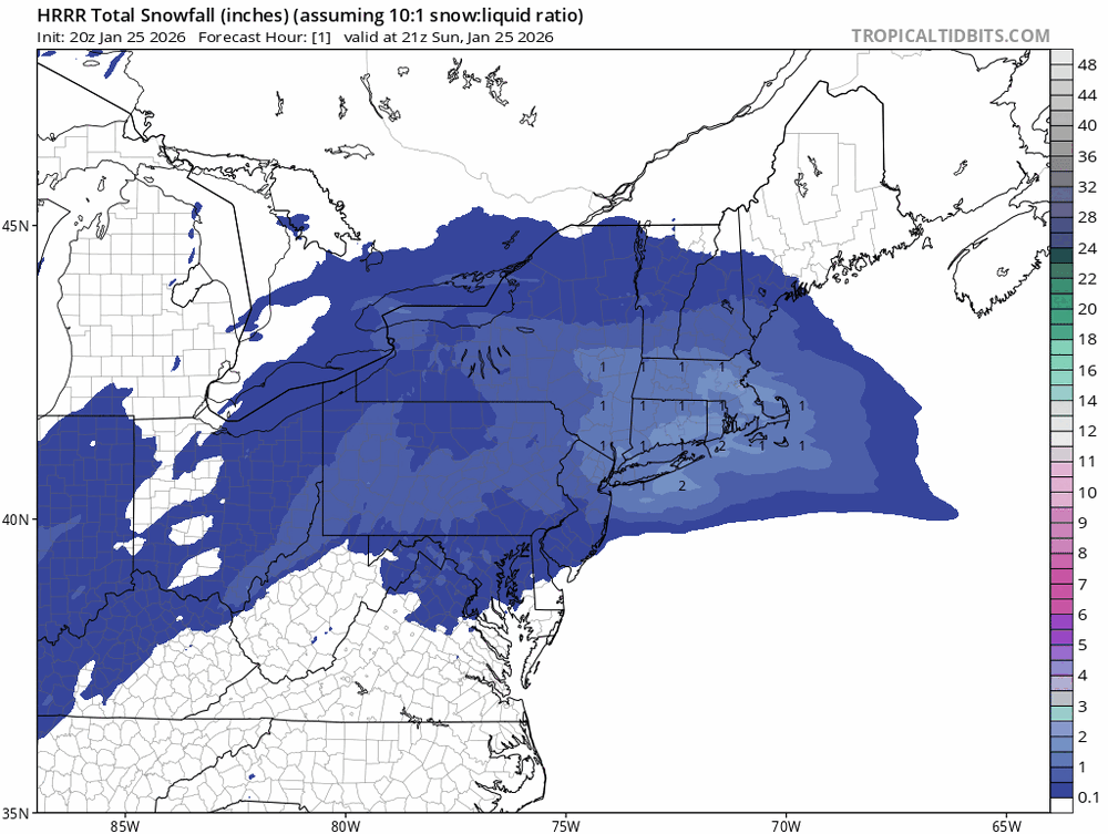
Do you think it’s going to be pure fluff after 6 days of melting in the sun and then refreezing? I have like 18” on my roof. Another 2 feet on top of that wouldn’t be great. And it’s too high for one of those scrapers.
-
I’m kind of hoping this one misses. The piles at the end of my driveway are already shoulder high and I’m running out of room. With temps this week bitterly cold not much will melt. Starting to worry about my roof collapsing.
-
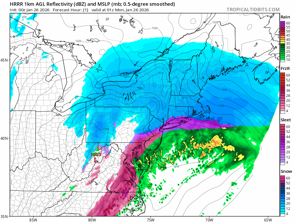
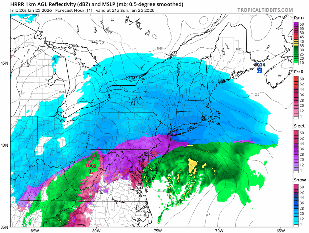
HRRR says that dry slot is gonna fill in

-
Snowing hard here again but that dry slot is coming fast.
-
You still got a lot of snow. There have been plenty of Miller A’s over the years where I’ve had little or nothing while you guys got smoked.
-
Yikes.
-
Yeah I see that. If that happens I’ll be over 20”.
-
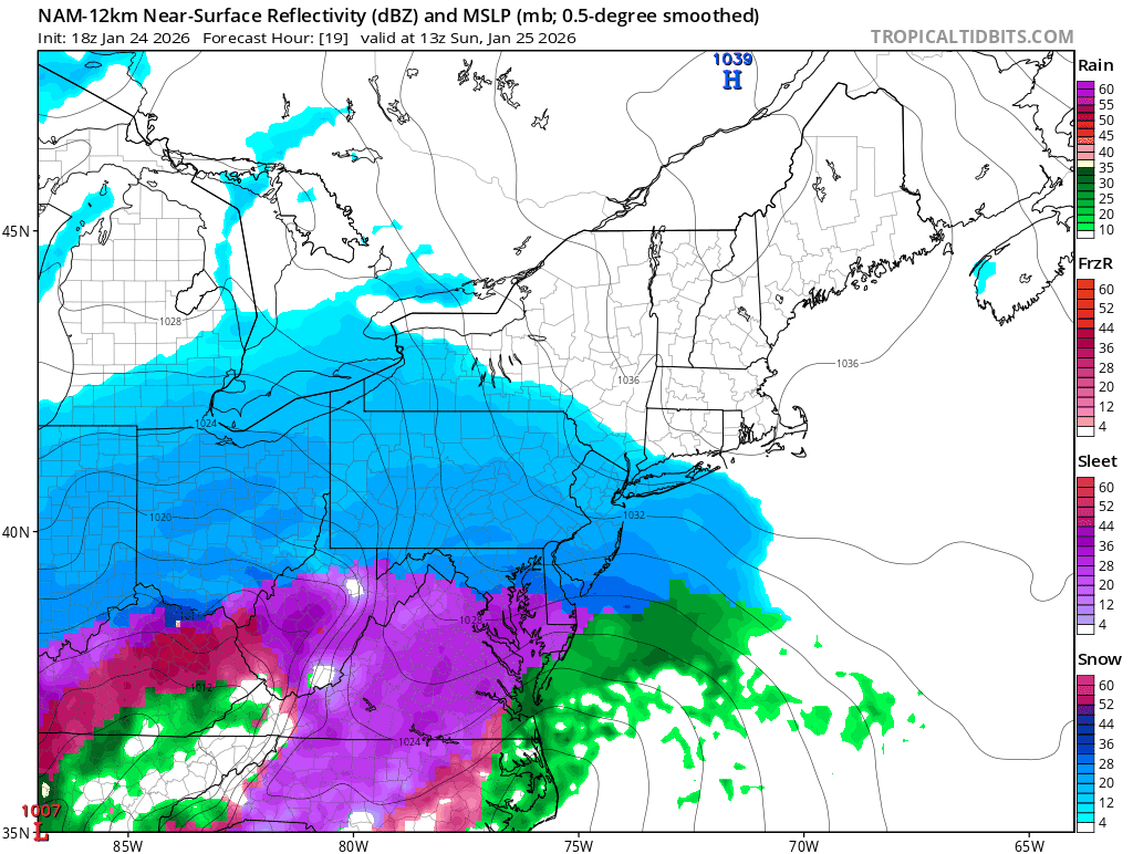
Radar looks plenty juiced to me. That dry slot is over Southern PA and might not even make it that far North. The HRRR has a very brief dry slot before another band comes through overnight.
-
I can confirm that there is some sleet mixing in here now but it’s still 90% snow and still accumulating rapidly.
-
LOL I think I’m at 15-16” here a few miles to your NW.
-
Still to come
-
There has been no sleet in Rockland. I live 2 miles North of 287/87 near the Palisades and it’s been all snow all day.
-
I’m well over a foot already. Probably going to finish close to 20”.
-
Extreme Cold, Snow & Sleet: SECS 1/24 - 1/26
NJwx85 replied to TriPol's topic in New York City Metro
Looks like the mix line has retreated South the past few frames. -
Extreme Cold, Snow & Sleet: SECS 1/24 - 1/26
NJwx85 replied to TriPol's topic in New York City Metro
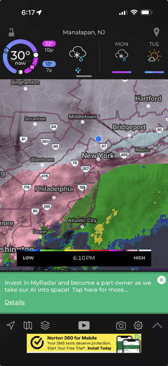
Right now it’s near 78 in NJ -
Extreme Cold, Snow & Sleet: SECS 1/24 - 1/26
NJwx85 replied to TriPol's topic in New York City Metro
I’m up over a foot. Still crazy rates here and no sleet in sight. Already made 2 passes with the snow blower. -
Extreme Cold, Snow & Sleet: SECS 1/24 - 1/26
NJwx85 replied to TriPol's topic in New York City Metro
I’m up over 5” already. Location is near New City in Central Rockland County. -
Extreme Cold, Snow & Sleet: SECS 1/24 - 1/26
NJwx85 replied to TriPol's topic in New York City Metro
I have over 3” here in Rockland already. Plow just went past. -
Extreme Cold, Snow & Sleet: SECS 1/24 - 1/26
NJwx85 replied to TriPol's topic in New York City Metro
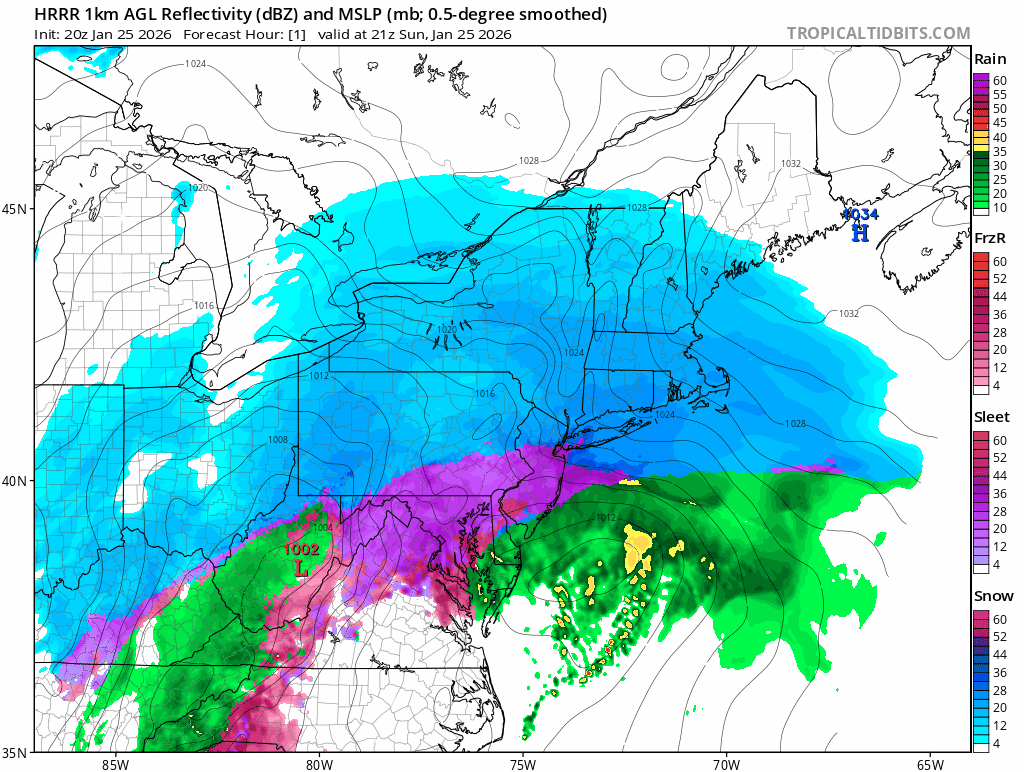
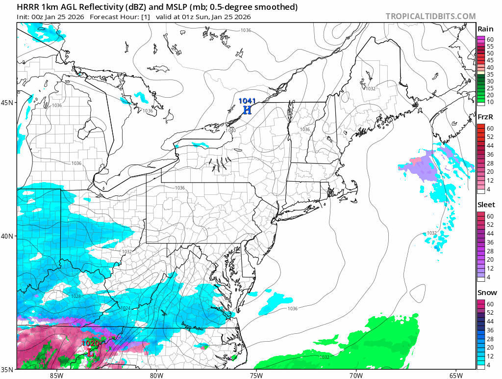
01z HRRR 1hr snowfall rates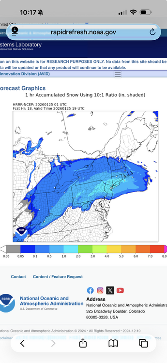
-
Extreme Cold, Snow & Sleet: SECS 1/24 - 1/26
NJwx85 replied to TriPol's topic in New York City Metro
Because this is a Miller B. This was the only option unless it stayed way suppressed to the South. -
Extreme Cold, Snow & Sleet: SECS 1/24 - 1/26
NJwx85 replied to TriPol's topic in New York City Metro
The NAM is actually a touch warmer. At this point I think it’s just noise.
-
Extreme Cold, Snow & Sleet: SECS 1/24 - 1/26
NJwx85 replied to TriPol's topic in New York City Metro

-
Extreme Cold, Snow & Sleet: SECS 1/24 - 1/26
NJwx85 replied to TriPol's topic in New York City Metro
The HRRR has a huge band of 1-2” per hour rates that approaches from the South at 17-18z and would persist for many hours. -
Extreme Cold, Snow & Sleet: SECS 1/24 - 1/26
NJwx85 replied to TriPol's topic in New York City Metro

-
Extreme Cold, Snow & Sleet: SECS 1/24 - 1/26
NJwx85 replied to TriPol's topic in New York City Metro
LOL Very few people here actually live in NYC proper.