NJwx85
-
Posts
19,685 -
Joined
-
Last visited
Content Type
Profiles
Blogs
Forums
American Weather
Media Demo
Store
Gallery
Everything posted by NJwx85
-
Major Hurricane Melissa - 892mb - 185mph Jamaica landfall
NJwx85 replied to GaWx's topic in Tropical Headquarters
It does look like there is an attempt at building a core. The “eye” is warming. -
Major Hurricane Melissa - 892mb - 185mph Jamaica landfall
NJwx85 replied to GaWx's topic in Tropical Headquarters
I think the IR loop presentation now is more indicative of a truck tire (hollowed out core) than the emergence of an actual eyewall. We’ve seen this happen many times after significant land interaction and then reemergence. Hard to tell without recon or radar though. -
Major Hurricane Melissa - 892mb - 185mph Jamaica landfall
NJwx85 replied to GaWx's topic in Tropical Headquarters
The motion looks almost Easterly right now. That would prolong time over water. The core appears to be mostly intact, at least based on IR. -
Major Hurricane Melissa - 892mb - 185mph Jamaica landfall
NJwx85 replied to GaWx's topic in Tropical Headquarters
Has anyone heard from Josh since LF? His last tweet was about 5 hrs ago before the worst hit. -
Major Hurricane Melissa - 892mb - 185mph Jamaica landfall
NJwx85 replied to GaWx's topic in Tropical Headquarters
Nova Scotia better watch out. Lots of guidance tracks this very close to Atlantic Canada in about 96hrs. This after hits on Cuba, the Bahamas and Bermuda likely. -
Major Hurricane Melissa - 892mb - 185mph Jamaica landfall
NJwx85 replied to GaWx's topic in Tropical Headquarters
The eye is slowly constricting as you would expect, but the remainder of the structure is holding together remarkably well considering the land interaction and high terrain. -
Major Hurricane Melissa - 892mb - 185mph Jamaica landfall
NJwx85 replied to GaWx's topic in Tropical Headquarters
It probably peaked about 3 hours ago, but my guess is second LF into Cuba as a high end major. Probably 125kts if I had to guess. -
Major Hurricane Melissa - 892mb - 185mph Jamaica landfall
NJwx85 replied to GaWx's topic in Tropical Headquarters
The water is about the same but shear will be gradually increasing. -
Major Hurricane Melissa - 892mb - 185mph Jamaica landfall
NJwx85 replied to GaWx's topic in Tropical Headquarters
It’s moving almost due North, right along 78W. It should be back over water in 2-3 hours. It’s a much shorter trip than if it was moving more Northeasterly. It also will keep it over water longer before reaching Cuba. -
Major Hurricane Melissa - 892mb - 185mph Jamaica landfall
NJwx85 replied to GaWx's topic in Tropical Headquarters
This is what happens, especially when you consider the high terrain. But, the Northeastern portion of the eye wall is already more than halfway across. -
Major Hurricane Melissa - 892mb - 185mph Jamaica landfall
NJwx85 replied to GaWx's topic in Tropical Headquarters
Do you guys think it will weaken significantly before hitting Cuba? It’s moving awfully fast now and Jamaica is rather narrow, to the point that the Northern eye wall will reemerge rather quickly after landfall. -
Major Hurricane Melissa - 892mb - 185mph Jamaica landfall
NJwx85 replied to GaWx's topic in Tropical Headquarters
It looks like the NE portion of the eye wall is almost on shore. Landfall seems likely in the 3-4 hours. -
Major Hurricane Melissa - 892mb - 185mph Jamaica landfall
NJwx85 replied to GaWx's topic in Tropical Headquarters

-
Major Hurricane Melissa - 892mb - 185mph Jamaica landfall
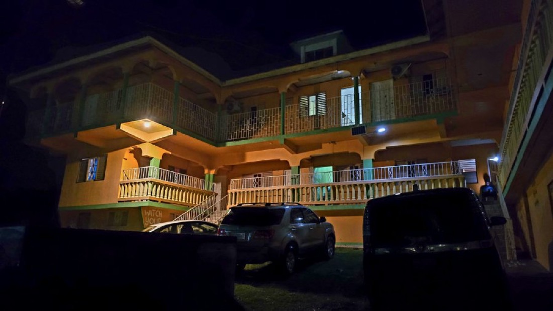
NJwx85 replied to GaWx's topic in Tropical Headquarters
This is the shelter Josh chose. It’s a solid concrete hotel. I remember worrying about him with Dorian and Haiyan but he always pulls through. He might be stuck on the island for awhile but he’s prepared as always. I wish he still posted here.
-
Major Hurricane Melissa - 892mb - 185mph Jamaica landfall
NJwx85 replied to GaWx's topic in Tropical Headquarters
That part of the basin was also running 3-4 degrees C above average. The water there is in the mid to upper 80’s. Pure rocket fuel, which went untapped all season. We knew this would blow up as soon as the shear relaxed. It was a very vigorous wave that made it all the way from Africa and overcame a lot to make it there. The vortex is highly battle tested. -
Major Hurricane Melissa - 892mb - 185mph Jamaica landfall
NJwx85 replied to GaWx's topic in Tropical Headquarters
ERC’s and what causes them are still largely unknown. -
Major Hurricane Melissa - 892mb - 185mph Jamaica landfall
NJwx85 replied to GaWx's topic in Tropical Headquarters
-80c cloud tops have now completely wrapped around the entire CDO. It’s definitively a higher end Cat 5 at this point. -
Major Hurricane Melissa - 892mb - 185mph Jamaica landfall
NJwx85 replied to GaWx's topic in Tropical Headquarters
Looks like tidbits is having issues. Server overload it seems. -
Major Hurricane Melissa - 892mb - 185mph Jamaica landfall
NJwx85 replied to GaWx's topic in Tropical Headquarters
As others pointed out, it has made the loop. Looks like that’s it. Locked and loaded on Jamaica now. Looks like recon is well timed. Peak intensity likely here. -
Major Hurricane Melissa - 892mb - 185mph Jamaica landfall
NJwx85 replied to GaWx's topic in Tropical Headquarters
It seems almost a certainty at this point that Melissa reaches 79W. I wonder if the close proximity to the mountainous terrain in Jamaica is somehow impacting the steering flow. -
Major Hurricane Melissa - 892mb - 185mph Jamaica landfall
NJwx85 replied to GaWx's topic in Tropical Headquarters
-
Major Hurricane Melissa - 892mb - 185mph Jamaica landfall
NJwx85 replied to GaWx's topic in Tropical Headquarters
They kept it at 175mph. However the discussion says the inbound aircraft might find Melissa stronger than 150kts. -
Major Hurricane Melissa - 892mb - 185mph Jamaica landfall
NJwx85 replied to GaWx's topic in Tropical Headquarters
Latest Dvorak estimates are in the 165 to 170kts neighborhood. I bet we get 160kts at 5pm. -
Major Hurricane Melissa - 892mb - 185mph Jamaica landfall
NJwx85 replied to GaWx's topic in Tropical Headquarters
On a side note, -80C cloud tops or colder have now wrapped around the Eastern 2/3rds of the CDO. Hard to remember that happening before in the Atlantic. Only other example I can recall is Dorian at peak intensity. -
Major Hurricane Melissa - 892mb - 185mph Jamaica landfall
NJwx85 replied to GaWx's topic in Tropical Headquarters
The mean motion is more Westerly again. I think we’re seeing an example of an intense hurricane amplifying the ridging to its North. This of course is being counteracted by the trough building into the Southeast US and making for quite the battle. I fully expect the eventual hard turn but Melissa continues to track to the West of most guidance and the official track. Even these small shifts can have major implications regarding landfall location.