NJwx85
-
Posts
19,676 -
Joined
-
Last visited
Content Type
Profiles
Blogs
Forums
American Weather
Media Demo
Store
Gallery
Everything posted by NJwx85
-
I’m well over a foot already. Probably going to finish close to 20”.
-
Extreme Cold, Snow & Sleet: SECS 1/24 - 1/26
NJwx85 replied to TriPol's topic in New York City Metro
Looks like the mix line has retreated South the past few frames. -
Extreme Cold, Snow & Sleet: SECS 1/24 - 1/26
NJwx85 replied to TriPol's topic in New York City Metro
Right now it’s near 78 in NJ -
Extreme Cold, Snow & Sleet: SECS 1/24 - 1/26
NJwx85 replied to TriPol's topic in New York City Metro
I’m up over a foot. Still crazy rates here and no sleet in sight. Already made 2 passes with the snow blower. -
Extreme Cold, Snow & Sleet: SECS 1/24 - 1/26
NJwx85 replied to TriPol's topic in New York City Metro
I’m up over 5” already. Location is near New City in Central Rockland County. -
Extreme Cold, Snow & Sleet: SECS 1/24 - 1/26
NJwx85 replied to TriPol's topic in New York City Metro
I have over 3” here in Rockland already. Plow just went past. -
Extreme Cold, Snow & Sleet: SECS 1/24 - 1/26
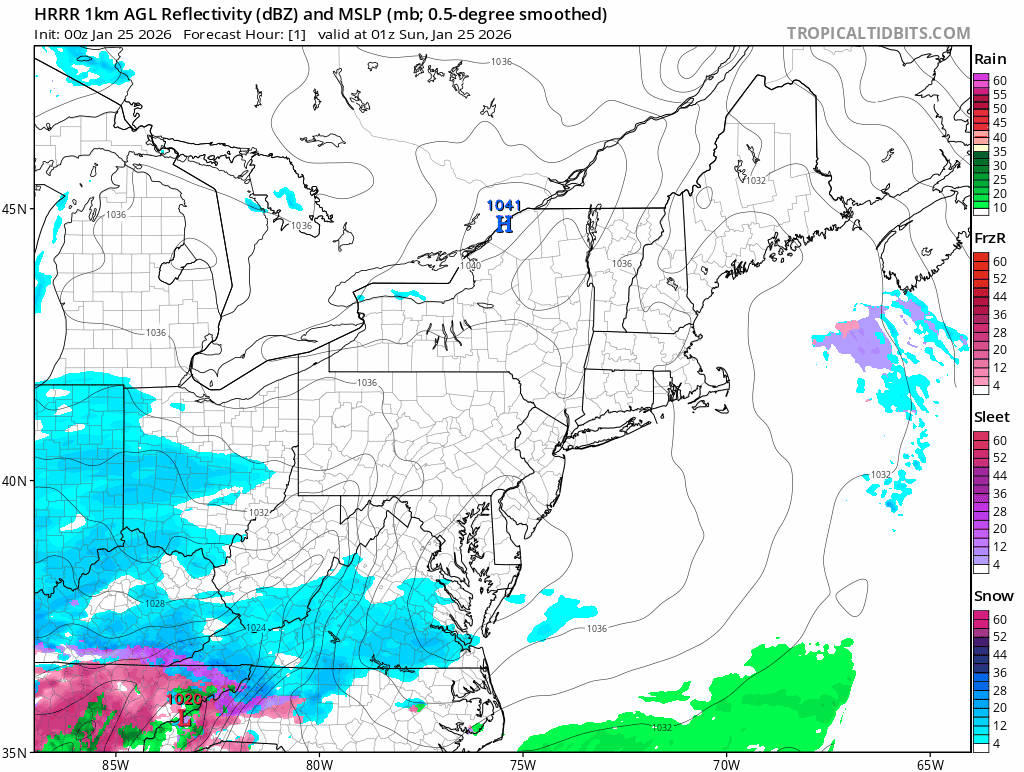
NJwx85 replied to TriPol's topic in New York City Metro
01z HRRR 1hr snowfall rates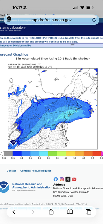
-
Extreme Cold, Snow & Sleet: SECS 1/24 - 1/26
NJwx85 replied to TriPol's topic in New York City Metro
Because this is a Miller B. This was the only option unless it stayed way suppressed to the South. -
Extreme Cold, Snow & Sleet: SECS 1/24 - 1/26
NJwx85 replied to TriPol's topic in New York City Metro
The NAM is actually a touch warmer. At this point I think it’s just noise.
-
Extreme Cold, Snow & Sleet: SECS 1/24 - 1/26
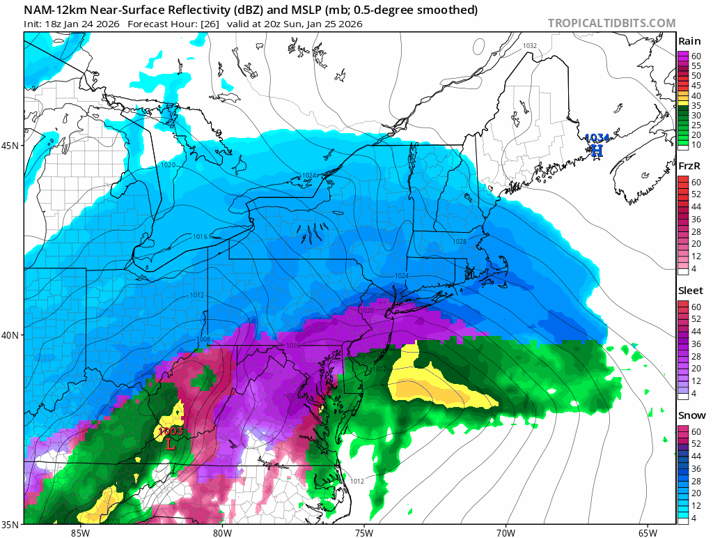
NJwx85 replied to TriPol's topic in New York City Metro

-
Extreme Cold, Snow & Sleet: SECS 1/24 - 1/26
NJwx85 replied to TriPol's topic in New York City Metro
The HRRR has a huge band of 1-2” per hour rates that approaches from the South at 17-18z and would persist for many hours. -
Extreme Cold, Snow & Sleet: SECS 1/24 - 1/26
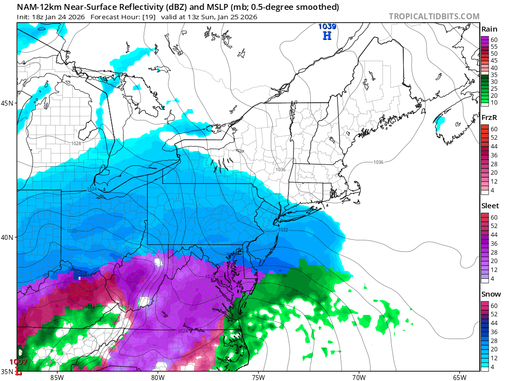
NJwx85 replied to TriPol's topic in New York City Metro

-
Extreme Cold, Snow & Sleet: SECS 1/24 - 1/26
NJwx85 replied to TriPol's topic in New York City Metro
LOL Very few people here actually live in NYC proper. -
Extreme Cold, Snow & Sleet: SECS 1/24 - 1/26
NJwx85 replied to TriPol's topic in New York City Metro
Once again, this is confined to areas well South of where most people here live. -
Extreme Cold, Snow & Sleet: SECS 1/24 - 1/26
NJwx85 replied to TriPol's topic in New York City Metro
Everyone should be ripping by 9am. -
Extreme Cold, Snow & Sleet: SECS 1/24 - 1/26
NJwx85 replied to TriPol's topic in New York City Metro
To be fair that only shows mixing in the Southern third of the forum and barely at that. -
Extreme Cold, Snow & Sleet: SECS 1/24 - 1/26
NJwx85 replied to TriPol's topic in New York City Metro
I think the bigger issue is that the mid level warning will hurt rates quite a bit. Some areas might start off at 12 or 15 to 1 and go down to half that by sunset. -
Extreme Cold, Snow & Sleet: SECS 1/24 - 1/26
NJwx85 replied to TriPol's topic in New York City Metro
Most of what falls before sunrise is probably virga. -
Extreme Cold, Snow & Sleet: SECS 1/24 - 1/26
NJwx85 replied to TriPol's topic in New York City Metro
cap cod sounds like an elegant fish dish. -
Extreme Cold, Snow & Sleet: SECS 1/24 - 1/26
NJwx85 replied to TriPol's topic in New York City Metro
Couldn’t agree more. I think the heavier rates will help to overcome the borderline mid level warming. The charge to sleet probably only happens once a majority of the precip has already fallen, sometime after 02-03z. -
Extreme Cold, Snow & Sleet: SECS 1/24 - 1/26
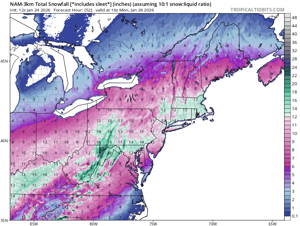
NJwx85 replied to TriPol's topic in New York City Metro
Nice trend on the 3k NAM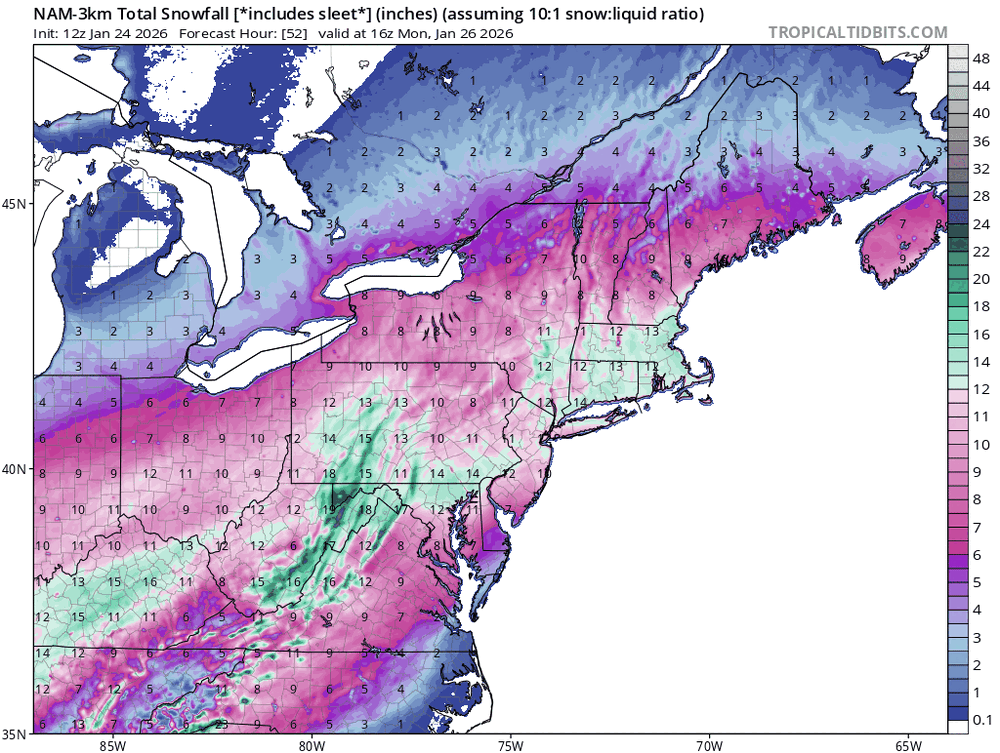
-
Extreme Cold, Snow & Sleet: SECS 1/24 - 1/26
NJwx85 replied to TriPol's topic in New York City Metro
The NAM is prone to very large run to run swings, even in the short term and it usually overdoes everything which leads to wild solutions at times. I can think of only one event where it was very different from the consensus and ended up being right. Very few mets use it to make a forecast. It’s primarily fun to look at. It does have its usefulness but I certainly wouldn’t favor it over other guidance. -
Extreme Cold, Snow & Sleet: SECS 1/24 - 1/26
NJwx85 replied to TriPol's topic in New York City Metro
The UKMET has a warm bias so seeing it this cold is a red flag that the warning might be slightly overdone. -
Extreme Cold, Snow & Sleet: SECS 1/24 - 1/26
NJwx85 replied to TriPol's topic in New York City Metro
Honestly, while the threat for sleet at the end is increasing somewhat, many here are way overreacting. Take a compromise and you get one heck of a snowstorm for just about everyone. -
Extreme Cold, Snow & Sleet: SECS 1/24 - 1/26
NJwx85 replied to TriPol's topic in New York City Metro
All that really matters anymore is where the primary transfers to the coast. The further North that happens, the more warm air will be pumped in but also the more precip there will be. It’s a double edged sword. The rest is just noise.