StormchaserChuck!
-
Posts
2,274 -
Joined
-
Last visited
Content Type
Profiles
Blogs
Forums
American Weather
Media Demo
Store
Gallery
Everything posted by StormchaserChuck!
-

Feb Long Range Discussion (Day 3 and beyond) - MERGED
StormchaserChuck! replied to WinterWxLuvr's topic in Mid Atlantic
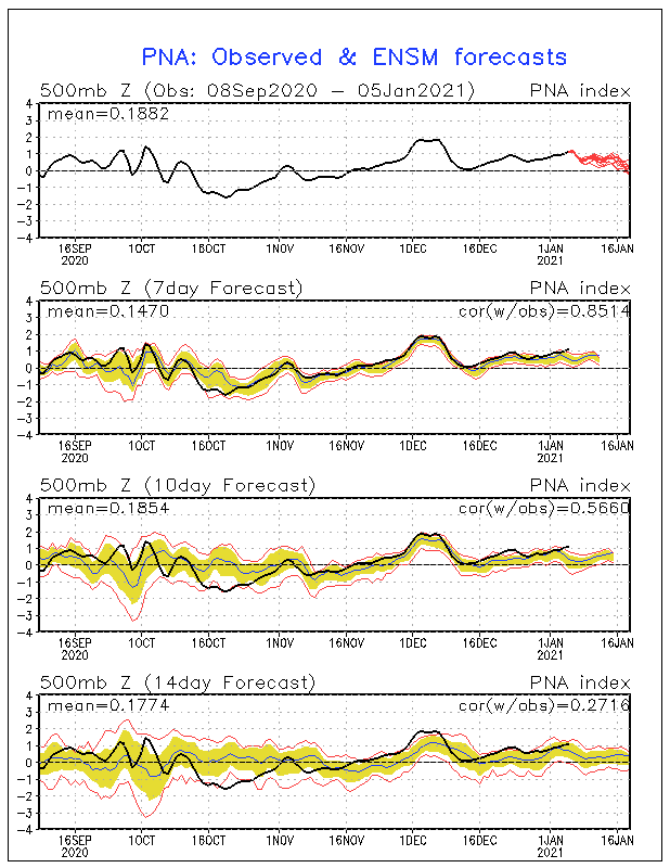
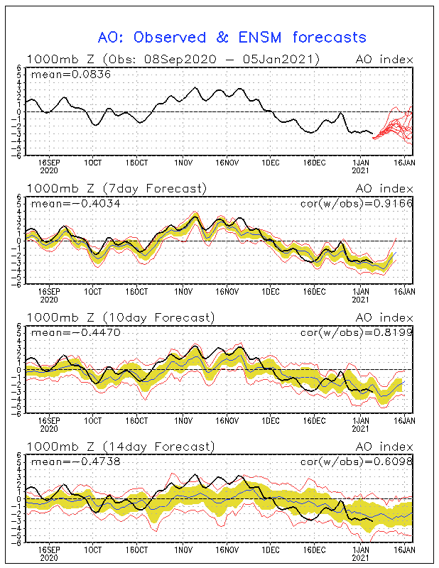
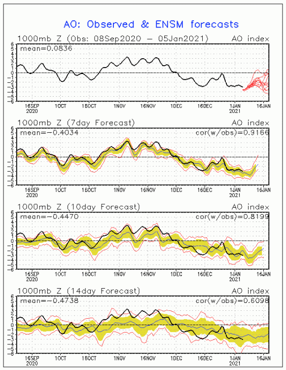
I think it's amazing that it's mid-January and we have a -NAO and it's raining, and it's not even close. 50*. +PNA isn't getting far south anymore lol -
Feb Long Range Discussion (Day 3 and beyond) - MERGED
StormchaserChuck! replied to WinterWxLuvr's topic in Mid Atlantic
Re: the storm, model trends are random so all people are really doing is describing. Logical function of real current (energy) is that the NAO is probably not going to trend more negative.. 33 months +NAO in a row, and if it does go negative, it will happen with parallel East coast warming trend, The -PNA is new, and happens strong and rapidly. I've seen that around Jan 14th when this develops on models it doesn't go away and trend -1 to +3 greater in the next 20 days, but about the same for the storm. That is not favorable but it is midWinter. -
Feb Long Range Discussion (Day 3 and beyond) - MERGED
StormchaserChuck! replied to WinterWxLuvr's topic in Mid Atlantic
Montana has been cold. Psychological manipulation of population-based climate control is my guess. -
Feb Long Range Discussion (Day 3 and beyond) - MERGED
StormchaserChuck! replied to WinterWxLuvr's topic in Mid Atlantic
Maybe if you moved to the West coast it would be different? Greenlandblocks are not what they used to be. There's like a 2nd rule with Greenland block. -
Feb Long Range Discussion (Day 3 and beyond) - MERGED
StormchaserChuck! replied to WinterWxLuvr's topic in Mid Atlantic
They must have time travel technology. -
Feb Long Range Discussion (Day 3 and beyond) - MERGED
StormchaserChuck! replied to WinterWxLuvr's topic in Mid Atlantic
There's some angry people here.. -
Feb Long Range Discussion (Day 3 and beyond) - MERGED
StormchaserChuck! replied to WinterWxLuvr's topic in Mid Atlantic
So the -NAO/cold wave burns out in Europe, how do we not go from the SW after that? -
Feb Long Range Discussion (Day 3 and beyond) - MERGED
StormchaserChuck! replied to WinterWxLuvr's topic in Mid Atlantic
gonna bake everyone alive in a solar flare lol -
Feb Long Range Discussion (Day 3 and beyond) - MERGED
StormchaserChuck! replied to WinterWxLuvr's topic in Mid Atlantic
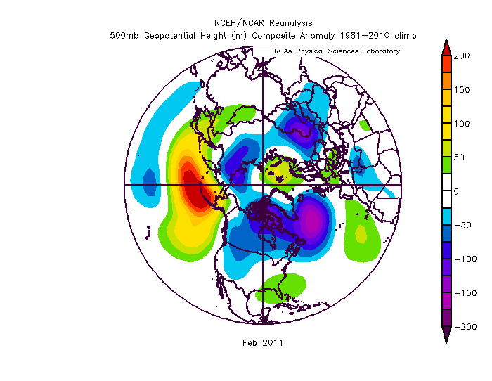
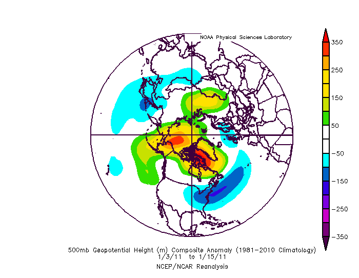
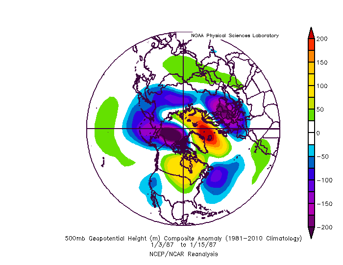
The last time we had -NAO in january was 2011 February: That February is a -AAM pattern, which would be weak at this point in La Nina because a warm push is coming in, and it's either to happen over enso or the Hemisphere. March-April will be warm.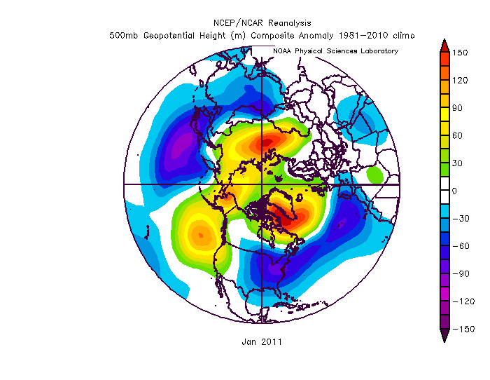
-
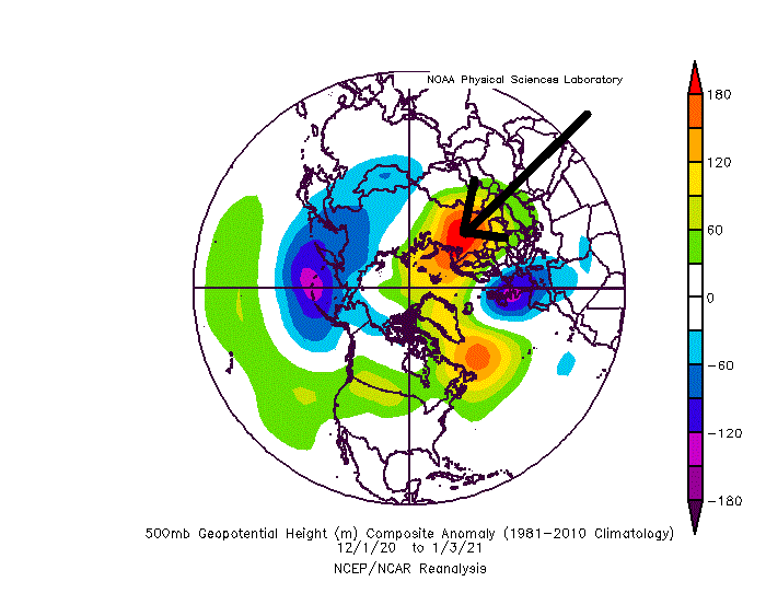
25th https://www.americanwx.com/bb/topic/53528-winter-2020-21-discussion/?do=findComment&comment=5621946
-
I was going to say before, this is lol for no real Winter That arrow area usually precedes warm Jan 25-Feb 15 fwiw.
-
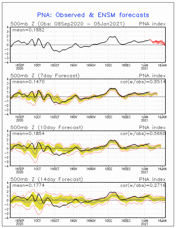
I really like the -NAO+PNA setup around mid-January. I doubt we'll get a +PNA so far south in La Nina, but we'll see. This area seems to be leading the indexes.
-
2019 ENSO
StormchaserChuck! replied to AfewUniversesBelowNormal's topic in Weather Forecasting and Discussion
That is some warm subsurface water building in the western subsurface. I wouldn't be surprised if we just rollercoaster this pattern until May-June. If we see a La Nina develop in April, I would be surprised, and it would definitely mean something else. -
-
-NAO and it's 60 degrees lol
-
2020 Atlantic Hurricane Season
StormchaserChuck! replied to Windspeed's topic in Tropical Headquarters
How many storms next year, 17-20? It looks like we will be leaning El Nino, at least in April-May so... -
Winter 20-21 Discussion
StormchaserChuck! replied to griteater's topic in Weather Forecasting and Discussion
It sometimes takes a +climate event to get a +WPO- or vortex over the Bering straight. The default, especially in this time of melting arctic ice is ridging there. Descending PDO from June on, through November looks like this:
-
Winter 20-21 Discussion
StormchaserChuck! replied to griteater's topic in Weather Forecasting and Discussion
WPO is usually a 10-15 day cycle, it trends into -NAO at like -0.1 correlation, and switches in 30 days at +0.05 correlation. I did all indexes +60 days one time. -
It's been a long time since we had a +500dm -NAO (March 2018 maybe).
-
2019 ENSO
StormchaserChuck! replied to AfewUniversesBelowNormal's topic in Weather Forecasting and Discussion
Yeah, I found there's about a 60% correlation to NAO from November to December based on data, probably closer to 55-58% in reality. -
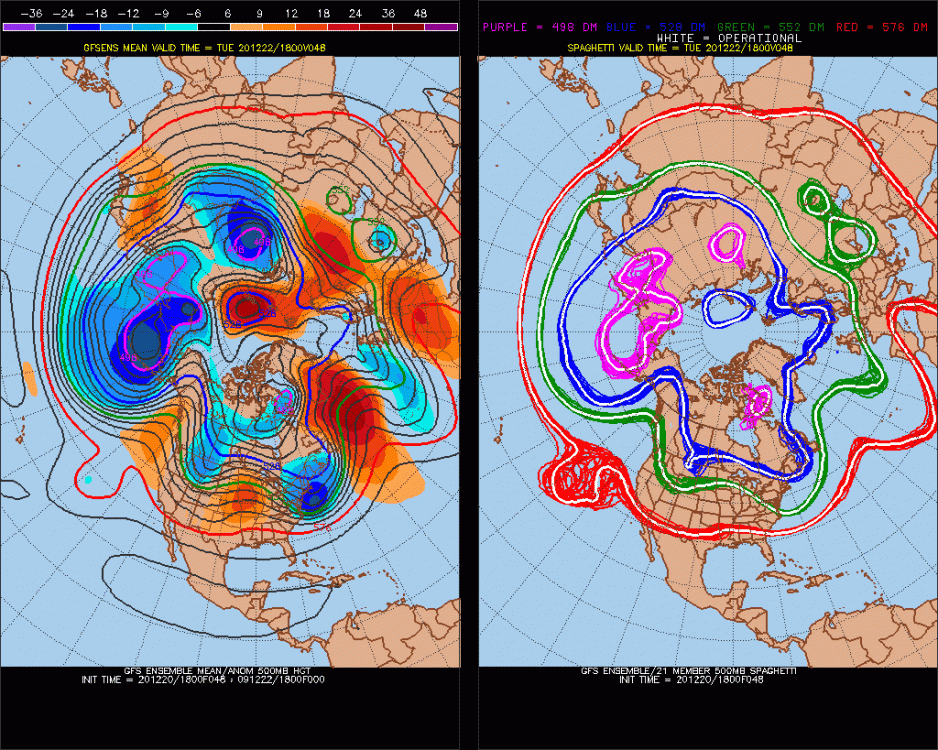
How about that ~ -2.00 NAO for mid-late Dec/early Jan on 12z models! I wonder if that means it will be +NAO Jan 10-March because the N. Atlantic NAO index was -0.1 for the Winter.
-
What a -WPO! Sometimes a -WPO around Dec 22/23 leads to a -EPO/-WPO around Jan 10-15, at the least not a +EPO at that time, I think.
-
2019 ENSO
StormchaserChuck! replied to AfewUniversesBelowNormal's topic in Weather Forecasting and Discussion
NAO sometimes switches around the Winter solstice, or up to 2 weeks later. I found that connection to be true. -
lol I vote for digital snow.
-
2019 ENSO
StormchaserChuck! replied to AfewUniversesBelowNormal's topic in Weather Forecasting and Discussion
Well, I believe in ENSO.