

StormchaserChuck!
-
Posts
2,274 -
Joined
-
Last visited
Content Type
Profiles
Blogs
Forums
American Weather
Media Demo
Store
Gallery
Everything posted by StormchaserChuck!
-
I live in Fallston, Maryland.
-

Feb Long Range Discussion (Day 3 and beyond) - MERGED
StormchaserChuck! replied to WinterWxLuvr's topic in Mid Atlantic
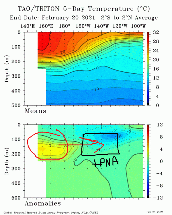
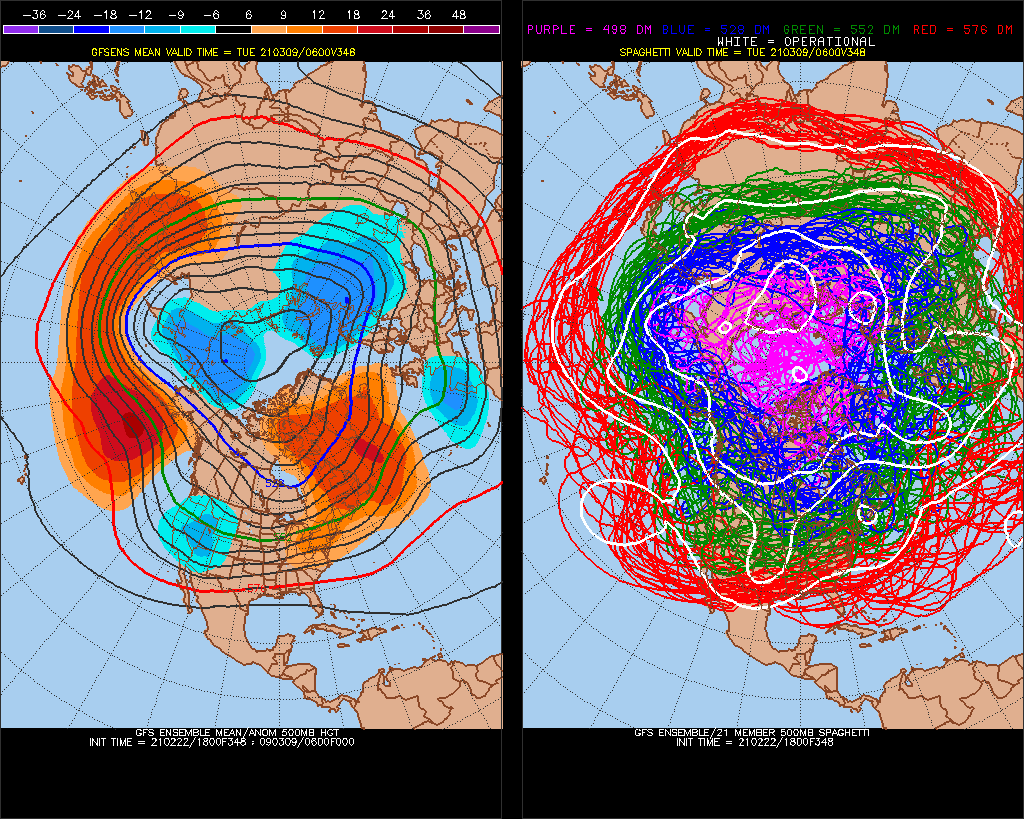
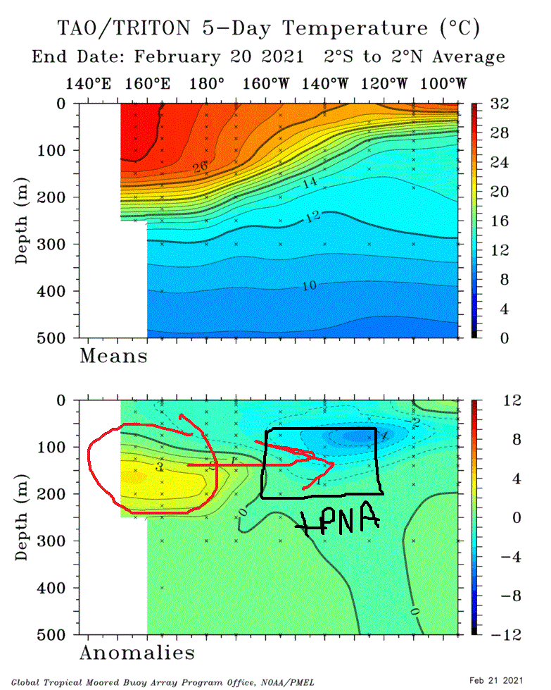
I wonder if the -NAO on LR models is going to build more +PNA in actuality. Here's 348hr.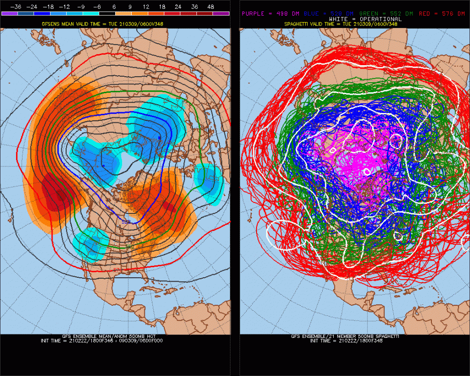
-
Feb Long Range Discussion (Day 3 and beyond) - MERGED
StormchaserChuck! replied to WinterWxLuvr's topic in Mid Atlantic
I'm on Kelvin wave watch. When the warm pool gets to 155-140W, it produces nice +PNA. -
Feb Long Range Discussion (Day 3 and beyond) - MERGED
StormchaserChuck! replied to WinterWxLuvr's topic in Mid Atlantic
There is a 2-4 year atmosphere lag after Strong El Nino of La Nina conditions in the North Pacific... interesting. I'm not sure it's even true. -
Winter 2020-2021 whining thread
StormchaserChuck! replied to BullCityWx's topic in Southeastern States
lol Can't catch a break I theorize that these are time travel points.
-
Feb Long Range Discussion (Day 3 and beyond) - MERGED
StormchaserChuck! replied to WinterWxLuvr's topic in Mid Atlantic
Yeah crazy man
-
Feb Long Range Discussion (Day 3 and beyond) - MERGED
StormchaserChuck! replied to WinterWxLuvr's topic in Mid Atlantic
Shades of last year in Pacific, and the last few years It continues I like this analog Wild card is potential Kelvin Wave, and we'll have a completely different scenario ,it will be opposite than last year. Something to watch out for.
-
Feb Long Range Discussion (Day 3 and beyond) - MERGED
StormchaserChuck! replied to WinterWxLuvr's topic in Mid Atlantic
06z GFS ensembles are trying to build a -NAO at Days 14-15, but I think that is to counter the Polar Vortex setting up over Alaska and the Bering Straight. I have also seen this bias with the last few Stratosphere warmings in time, they build on long range models, but dampen in closer time. Despite all the data/statistics/analogs I have posted about a -NAO March, I think the 33month trend is going to rule here. -
Feb Long Range Discussion (Day 3 and beyond) - MERGED
StormchaserChuck! replied to WinterWxLuvr's topic in Mid Atlantic
There is potential temperature energy here that will not be filled, that will be at another time. -
Feb Long Range Discussion (Day 3 and beyond) - MERGED
StormchaserChuck! replied to WinterWxLuvr's topic in Mid Atlantic
I'm amazed at this 15-day period of -PNA,+EPO coming up. The AO and NAO might also skew positive I think because of the swing of what has happened lately/trend. -
Feb Long Range Discussion (Day 3 and beyond) - MERGED
StormchaserChuck! replied to WinterWxLuvr's topic in Mid Atlantic
Today is the start of Spring.. no going back. I knew it standing outside today in the flurries.. today is the start of Spring. -
2021-2022 ENSO
StormchaserChuck! replied to StormchaserChuck!'s topic in Weather Forecasting and Discussion
I guess ENSO subsurface cold pool will strengthen until March 1st. Hard to do an El Nino after that, although there is the potential for a strong relative Kelvin wave. -
^I'll bet you the warmth in N. American and Europe evens out or cancels out the cold shortly.
-
Weather derivative's are pretty interesting, you can theoretically bet on temperatures in various cities.
-
Powerful, Nina's going to even out though.
-
Winter 20-21 Discussion
StormchaserChuck! replied to griteater's topic in Weather Forecasting and Discussion
I'm impressed by the -PNA. The +PNA bouts this Winter that seemed anomalous, ended up evening out 1:2. Expect the same next year and the next. -
Winter 20-21 Discussion
StormchaserChuck! replied to griteater's topic in Weather Forecasting and Discussion
It's not a big deal... -
Feb Long Range Discussion (Day 3 and beyond) - MERGED
StormchaserChuck! replied to WinterWxLuvr's topic in Mid Atlantic
Man, I nailed this storm. Let that be lesson, when the Pacific is so unfavorable, it doesn't snow.. indexes rule sometimes in some setups. The coming warm up was a sign, and we don't get storms coming out of -AO, not -NAO. -
Winter 20-21 Discussion
StormchaserChuck! replied to griteater's topic in Weather Forecasting and Discussion
^It's weird, like centered. That's what I'm talking about with February's lately. Cold retreats from the surface pretty early. -
Feb Long Range Discussion (Day 3 and beyond) - MERGED
StormchaserChuck! replied to WinterWxLuvr's topic in Mid Atlantic
I can't believe we have this PNA pattern in the Pacific for the storm, but look at the -AO exiting. I wonder what February snowstorms look like.. Check out this coming after though (Pacific-Alaska).thumb.gif.e61b94643ee0b4c2fdda385ce209847e.gif)
.thumb.gif.779a6ec07e7ff74a9d53cdbe0a58a069.gif)
-
Feb Long Range Discussion (Day 3 and beyond) - MERGED
StormchaserChuck! replied to WinterWxLuvr's topic in Mid Atlantic
Weird models.. we have a super powerful warm pattern coming up in the 6-10 day. I wouldn't be surprised if it breaches 70 one day near DC. -
Winter 20-21 Discussion
StormchaserChuck! replied to griteater's topic in Weather Forecasting and Discussion
My N. Atlantic SST NAO predictor for the Winter (Dec-Mar) was -0.1, that is turning out to be a great call considering we had not had a single negative NAO Winter month since 2013. -
Feb Long Range Discussion (Day 3 and beyond) - MERGED
StormchaserChuck! replied to WinterWxLuvr's topic in Mid Atlantic
It's not going to snow unless the indexes change. It's the start of a really warm period, it will be interesting to see if that forward happening blends back to the storm. -
Winter 20-21 Discussion
StormchaserChuck! replied to griteater's topic in Weather Forecasting and Discussion
Yeah, Montana has always been cold in February lately. -
Feb Long Range Discussion (Day 3 and beyond) - MERGED
StormchaserChuck! replied to WinterWxLuvr's topic in Mid Atlantic
I should have known when they were showing a tanking -NAO after we already had the coming-out-of-NAO storm. It almost never works out. The NAO always goes neutral or positive.


.gif.470210e5b143151410a02d09f3fece62.gif)
.gif.e8c30da7a28aae457e74aa54429ebdf8.gif)
