StormchaserChuck!
-
Posts
2,274 -
Joined
-
Last visited
Content Type
Profiles
Blogs
Forums
American Weather
Media Demo
Store
Gallery
Everything posted by StormchaserChuck!
-

Jan 31st - 33rd Storm Obs and Disco like it's 1979
StormchaserChuck! replied to Bob Chill's topic in Mid Atlantic
mm.. I can do anything. It's snowing all the way back to Illinois though, dry though. Good midWinter -NAO setting up -
Jan 31st - 33rd Storm Obs and Disco like it's 1979
StormchaserChuck! replied to Bob Chill's topic in Mid Atlantic
love how far west the back end is pivoting.. could be 10-15" here -
Feb Long Range Discussion (Day 3 and beyond) - MERGED
StormchaserChuck! replied to WinterWxLuvr's topic in Mid Atlantic
Could be a record -AO start to Winter through February, love to see how this evolves
-
Feb Long Range Discussion (Day 3 and beyond) - MERGED
StormchaserChuck! replied to WinterWxLuvr's topic in Mid Atlantic
-PNA pattern is really wet, if that's what happens -
Feb Long Range Discussion (Day 3 and beyond) - MERGED
StormchaserChuck! replied to WinterWxLuvr's topic in Mid Atlantic
Incredible that the Stratosphere is so warm too.. we could go -NAO through February. (I'd be interested to see what happens with that in the last week of the month.) -
Feb Long Range Discussion (Day 3 and beyond) - MERGED
StormchaserChuck! replied to WinterWxLuvr's topic in Mid Atlantic
Just incredible that it's so warm out.. goes with my theory that the Arctic ice real melt is lagging what it really is.. like, you know that by 2035-2040.. so things happen then, ya know? -
I don't like it.. it lifts north too far west, and that will only trend greater because of the atmosphere right now. If it snows, it will be in the mid to upper 50s a few days later, one of those deals, if not it will be a warm February.
-
Feb Long Range Discussion (Day 3 and beyond) - MERGED
StormchaserChuck! replied to WinterWxLuvr's topic in Mid Atlantic
Dude.. A -500dm west-based -NAO on January 26th, and it doesn't snow, it rains? It's like 50 degrees. The Pacific Ocean is a current that is closing in general, unless something more volitiale happens. I'm about to give up on this hobby. We could still see the occasional blizzard, but it will only last for like 2-3 days. -
2019 ENSO
StormchaserChuck! replied to AfewUniversesBelowNormal's topic in Weather Forecasting and Discussion
Check it out though, as we get a strengthening -trend-subsurface temperatures, with +trend-surface temperatures, monster -PNA of +500dm happens
-
2019 ENSO
StormchaserChuck! replied to AfewUniversesBelowNormal's topic in Weather Forecasting and Discussion
I'd be more impressed if the subsurface cold pool was not strengthening as it pulled back. (research shows the subsurface of ENSO has more + correlation to the 500mb pattern and surface temps than surface ENSO SSTs). -
One heck of a -NAO today and it's going to snow yay Going to unload into -PNA of about the same magnitude

-
Feb Long Range Discussion (Day 3 and beyond) - MERGED
StormchaserChuck! replied to WinterWxLuvr's topic in Mid Atlantic
Yeah, how do we create good upper air dynamics for thunderstorms? -
It looks like no El Nino above +0.7 will form next year, so I would go with this as my Winter forecast for 21-22..
-
2019 ENSO
StormchaserChuck! replied to AfewUniversesBelowNormal's topic in Weather Forecasting and Discussion
Kind of minimizing the potential for an El Nino a little bit (or a lot, anything greater than 0.7)... -
2019 ENSO
StormchaserChuck! replied to AfewUniversesBelowNormal's topic in Weather Forecasting and Discussion
The cold pool is actually retrograding a little bit When I see this I think of an active severe thunderstorm season. Warm pool still stronger though, I think well see some powerful Kelvin waves in the Spring.
-
Winter 20-21 Discussion
StormchaserChuck! replied to griteater's topic in Weather Forecasting and Discussion
Whoa, I was expecting you to say 60 days of it hitting 60. -
love this
-
Feb Long Range Discussion (Day 3 and beyond) - MERGED
StormchaserChuck! replied to WinterWxLuvr's topic in Mid Atlantic
AAM is rotation of the globe,... it's at like 0.001. lol just kidding -
Feb Long Range Discussion (Day 3 and beyond) - MERGED
StormchaserChuck! replied to WinterWxLuvr's topic in Mid Atlantic
You've seen my SSW post in the trash? It favors -NAO until Feb ~15-20 Not valid I think. -
Feb Long Range Discussion (Day 3 and beyond) - MERGED
StormchaserChuck! replied to WinterWxLuvr's topic in Mid Atlantic
I don't know.. I think it's weird that the -NAO empties into -PNA honestly. -
Feb Long Range Discussion (Day 3 and beyond) - MERGED
StormchaserChuck! replied to WinterWxLuvr's topic in Mid Atlantic
yay.. Im excited -
Feb Long Range Discussion (Day 3 and beyond) - MERGED
StormchaserChuck! replied to WinterWxLuvr's topic in Mid Atlantic
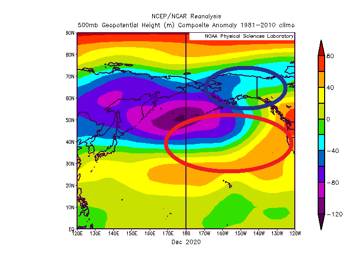
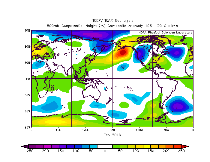
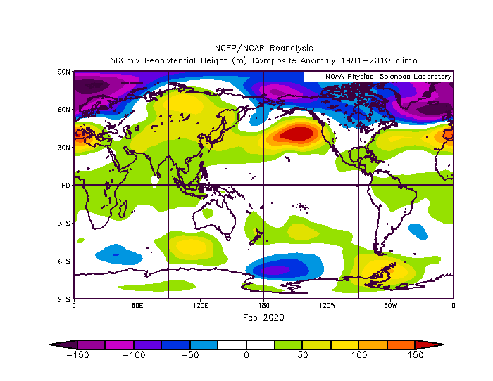
Hard to get anything other than -PNA in February lately. .. check this out well, 2018, 2019 and 2020 all had anomaly in same place.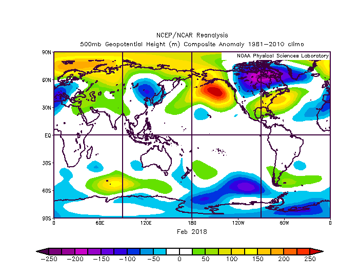
-
Feb Long Range Discussion (Day 3 and beyond) - MERGED
StormchaserChuck! replied to WinterWxLuvr's topic in Mid Atlantic
A little cold today for a -NAO, look at how it peaks in a few days... I wouldn't be surprised if the ridge underneath of it doesn't verify as amplified, or positive anomaly, as this. That's one heck of a -PNA though, just as..
-
Feb Long Range Discussion (Day 3 and beyond) - MERGED
StormchaserChuck! replied to WinterWxLuvr's topic in Mid Atlantic
I was saying Arctic ice melt was behind what was really happening for a few years now, since 2017-2018. -
Feb Long Range Discussion (Day 3 and beyond) - MERGED
StormchaserChuck! replied to WinterWxLuvr's topic in Mid Atlantic
Winter 20-21 lol I'd say this means we're on track on the evolutionary cycle though. (At a far away point there is a break-I believe.)