StormchaserChuck!
-
Posts
2,274 -
Joined
-
Last visited
Content Type
Profiles
Blogs
Forums
American Weather
Media Demo
Store
Gallery
Everything posted by StormchaserChuck!
-
I notice that we are in stuck climate pattern.. not like the 1990s. Meaning, big global oscillations are not oscillating. Only melting arctic sea ice, and even this is 20-30 years behind imo. I also notice that we are in a stuck economics with Google, Facebook, etc trillion dollar companies lol. I'm thinking we break through but it could take time. in the meantime, I notice much "filling in" a larger spectrum. It's an interesting theory, I would love to see how it verifies this Winter.
-

2019 ENSO
StormchaserChuck! replied to AfewUniversesBelowNormal's topic in Weather Forecasting and Discussion
It certainly looks like a negative ENSO in Atlantic tropics right now. -
I can give you good analysis... I have been following larger climate/global pattern indicators such as the Stock market, Crude Oil, NCEP climate pattern indicators researched extensively going back to 1948... I had seen a clear "cutoff" from norms or progression starting around 2017. This, for example, made a Strong El Nino unlikely without real catalyst or change. It was a "dead" pattern. Also, things were being "bought up ahead of time" in some cases (ie derivatives). The Pacific Jet has displaced way north. starting around 1995, you see a drier pattern in the SW, and around that time droughts started hitting California. In 2016, normal snows are now an anomaly in northern California. That pattern has not broke, and has only come back this Summer. Without a normal Pacific Jet hitting the West coast, we no longer have Alberta clippers here, etc. I am worried that it's already to start a "global warming Winter". just a dead pattern... ENSO has also been dead and accelerating toward Neutral around the middle of last year. I had wondered about new climate patterns, which have kind of started but they have not yet taken hold. We currently have a Weak Nina which is the best we are going to get and this could, at the very least, bring an early Spring. I was surprised that despite the Summer conditions a cold pool has developed over the favored spot in the Northern Atlantic for next Winter's -NAO. 34 Winter months of +NAO in a row, going back to 2013, will be very hard to break, but for the 2nd year in a row this indicator is favorable... I was interested in this because I had noticed a lot of things "filling out larger pattern" in regards to stats, even weather related, going back to 2018 and 2019 (I think this also happened in the 1960s and 70s). Given last Winter, I would see that "new pattern" in a 2 year pattern for that kind of condition to continue (ie +NAO-+EPO).. and because of stocks like AMZN (lol) I expect a "More opposite" this Winter, compared to last year., I just see how it sometimes fills out. If things like ENSO and PDO SSTs were kicking I would say a different thing.. I expect a few chances at 12" storms this Winter, because of thunderstorm season and rainfall anomaly patterns frankly, but an early warm late Winter-Spring. Overall a slightly above average temperature Winter, with average or slightly above average snowfall. Best chance is January for snow. We can pretty intimately track the storms.
-
2019 ENSO
StormchaserChuck! replied to AfewUniversesBelowNormal's topic in Weather Forecasting and Discussion
No Super-El Nino watch for next year, I think. We've got a little bit out of "dead pattern" but still have a long way to go I think before anything greater than ~0.7 develops. Maybe we will transition to warmer waters in the Spring though. Pretty interesting. -
2019 ENSO
StormchaserChuck! replied to AfewUniversesBelowNormal's topic in Weather Forecasting and Discussion
Subsurface definitely looks like a Weak Nina it usually drifts greater through October/Nov so maybe it will break -0.5. -
We actually have a -NAO signal here(, about -0.90 so far)
-
I still think we'll see something like this.. expect a good Winter.
.gif.be43866e0ab8a655c88877f14550a58f.gif)
-
Another drought for California, doesn't bode well for our Winter with the Pac Jet displaced all the way in Alaska.
-
I've been studying various global indicators right now.. I'd say expect the opposite of this, greater than 70-75%. We are in a "mixing within a large bowl" long term pattern, and you see this with the stock/currency market, how they are taking turns rising to percentages to even out, etc. I've seen this in observation of ENSO over the past 2 years, Hurricane seasons. (Sorry it starts off crappy, I've been meaning to say that for a while- much stock market analysis related to the greater climate phenomena.) It's a "dead" pattern right now, in a manner of speaking, for comparison, and I'm experiencing a big intuitive hit on opposite to even out. Pacific jet really far north has been a real climatological trend though over the past 5-10-15 years, and it is legitimately linked (I think) to melting arctic ice. We'll see.
-
2019 ENSO
StormchaserChuck! replied to AfewUniversesBelowNormal's topic in Weather Forecasting and Discussion
Believe it or not, there's more Atlantic tropical storms in negative-Neutral vs La Nina. We are already on "I" in July, which I think is a record. It keeps the strong currents more neutral. -
2019 ENSO
StormchaserChuck! replied to AfewUniversesBelowNormal's topic in Weather Forecasting and Discussion
Globals a little more solid now. -
2019 ENSO
StormchaserChuck! replied to AfewUniversesBelowNormal's topic in Weather Forecasting and Discussion
Yeah, the global system is not going to go La Nina below -0.8c 3.4 ONI. Weird. Invest in stocks. -
2019 ENSO
StormchaserChuck! replied to AfewUniversesBelowNormal's topic in Weather Forecasting and Discussion
^Looks like a Moderate Nina coming, as per the subsurface. Will be interesting to see if the surface 3.4 breaks -0.7 now or in the next 3 years. (Tao/Triton isn't as strong, I've found better correlation in TAO/Triton). -
2020 Atlantic Hurricane Season
StormchaserChuck! replied to Windspeed's topic in Tropical Headquarters
La Nina going in the Pacific subsurface.. I found a correlation of hurricane season subsurface vs surface 0.97 to 0.83 vs the 0.97 to 0.90. So it's a La Nina... but no severe wx season really, and a lot of blandness right now in the atmosphere will probably keep us away from Cat 4s or 5s. -
2019 ENSO
StormchaserChuck! replied to AfewUniversesBelowNormal's topic in Weather Forecasting and Discussion
Subsurface certainly looks like healthy La Nina.. it won't go there I think officially.. "Nuetral" global conditions are too prevalent (maybe we'll max out -0.5 to -0.7). https://www.pmel.noaa.gov/tao/drupal/assorted_plots/images/TAO_5Day_EQ_xz.gif -
The high rainfall increases chances for -NAO Winter..
-
The drought is in the upper atmosphere. Wait until towering cumulonibus start happening again and watch how Drought is at the surface.
-
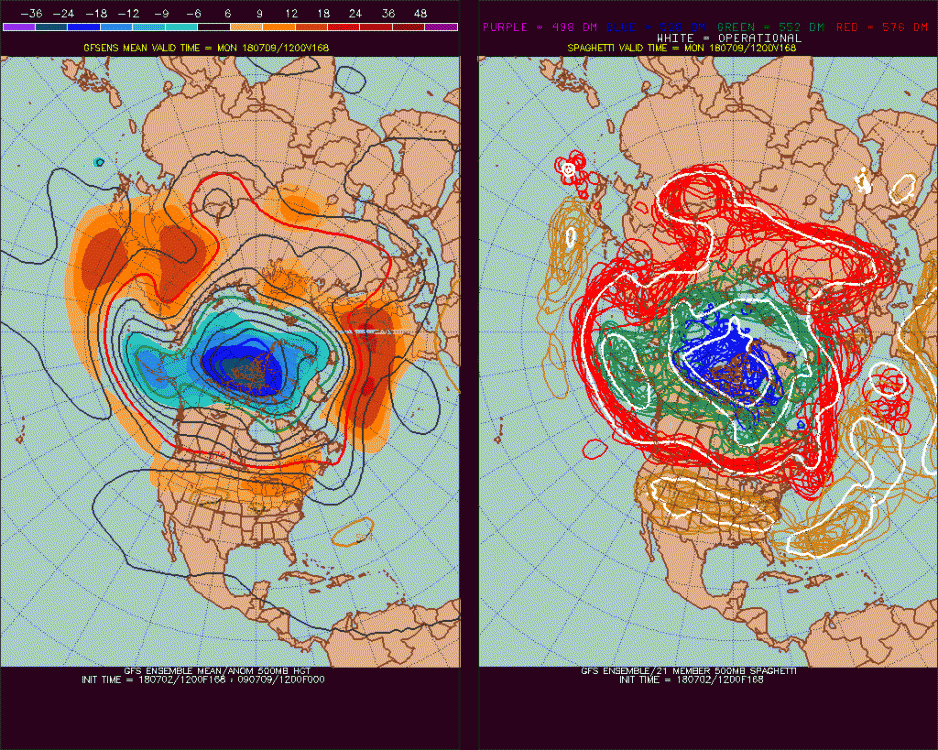
Arctic Sea Ice Extent, Area, and Volume
StormchaserChuck! replied to ORH_wxman's topic in Climate Change
Things have trended pretty strongly away from +AO today. Warmer at the surface trend looks to continue, perhaps significantly. I think there will be a lot of +500mb heights in the Arctic circle for July. Also, Pacific-squeezed north Hadley Cell sustainable rarely works in verification.. more blocking over the Pole. -
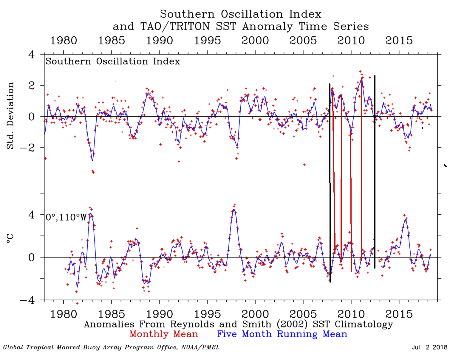
Arctic Sea Ice Extent, Area, and Volume
StormchaserChuck! replied to ORH_wxman's topic in Climate Change
This is pretty cool, SOI and ENSO SST correlate more (not in reverse) when arctic ice is melting (2007-2012).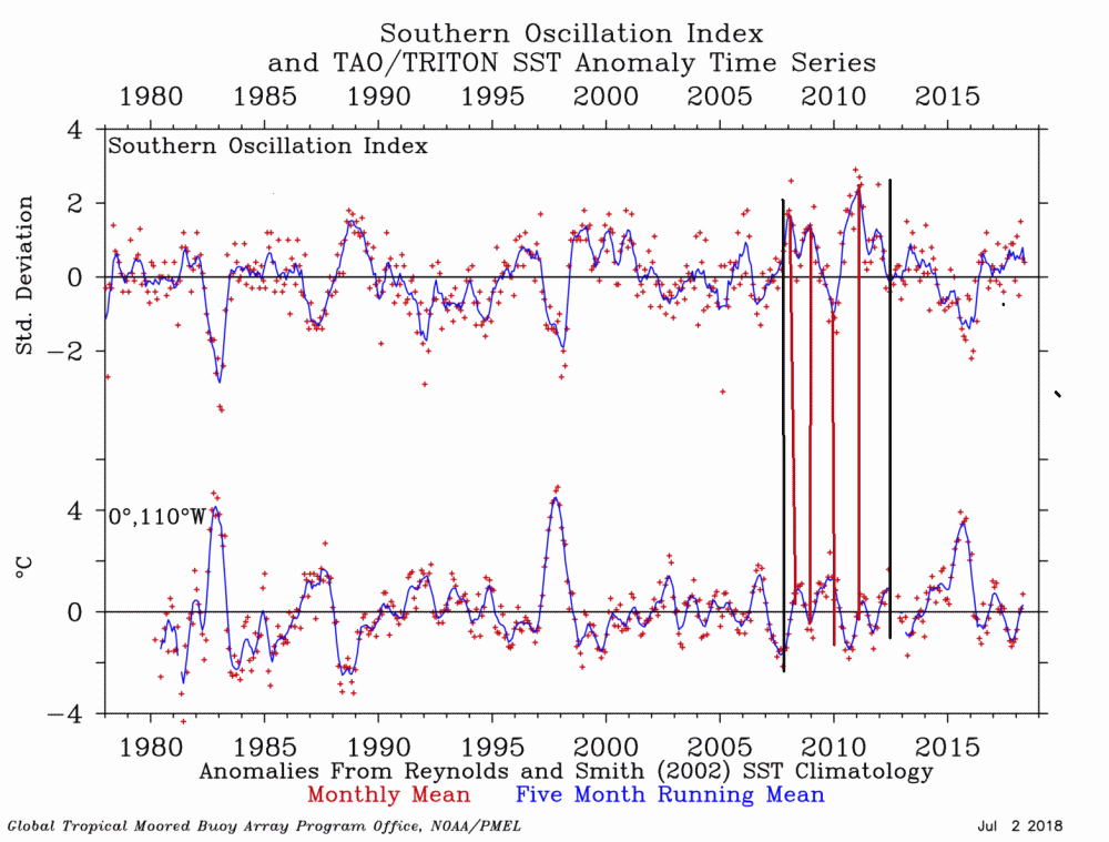
-
Arctic Sea Ice Extent, Area, and Volume
StormchaserChuck! replied to ORH_wxman's topic in Climate Change
This is kind of ridiculous. At least models are picking up on stuff.