StormchaserChuck!
-
Posts
2,274 -
Joined
-
Last visited
Content Type
Profiles
Blogs
Forums
American Weather
Media Demo
Store
Gallery
Everything posted by StormchaserChuck!
-
4,000 replies, what are you people crazy?
-

2019 ENSO
StormchaserChuck! replied to AfewUniversesBelowNormal's topic in Weather Forecasting and Discussion
Last frame of subsurface has some real warming... warm March. -
GFS has 12" here, I've seen this setup before with the Pacific-setup trend forward, and I would guess in actuality I get 3-6".
-
Our last Dec-Jan-Feb negative-NAO month was February 2013, 21 straight +months. November 2020 NAO was +2.54. December to be interesting to see what happens.
-
3rd little drought buster storm moving across the South now, and what do you expect Winter to be like? lol
-
Winter 20-21 Discussion
StormchaserChuck! replied to griteater's topic in Weather Forecasting and Discussion
El Nino or warm-neutral -
+PNA isn't going to verify like that, skew it warmer.. ridge north of Hawaii.
-
I think someone bought up all the cold Winter derivatives lol.
-
Horrible 3-month Winter by CPC, It proves they don't really know what's going on. I'm kind of looking forward to a -0.10 DJFM NAO prediction.
-
November Medium/Long Range Discussion
StormchaserChuck! replied to WinterWxLuvr's topic in Mid Atlantic
Nah, we are tightly in. I imagine currencies in other coutnries have different values in some different scenarios. -
November Medium/Long Range Discussion
StormchaserChuck! replied to WinterWxLuvr's topic in Mid Atlantic
NAO is gone on LR models. Man, that looks horrible. It just gets worse and worse. Usually in La Nina it carries over to January then Feb is probably too late already, because it's going to be an early Spring. -
Last year was a major bust, there have been 3-4 of them (major busts) in the last 50-70 years. fwiw
-
They are playing it conservative, it's really hard to have 2 shut outs in a row. Would be really interesting if the NAO goes like +2.00 this Winter.
-
Our last greatest snowstorm is Nov 15, 2018, 5.4". It's a long term cycle in the Pacific, I observe we are like 155-160 degrees at it. It would be interesting to see if we ever go back to Pacific trough if the Arctic ice melt rate accelerates toward or after the peak of the theoretical cycle.
-
I would predict slightly neutral-positive. Better than the last few years.
-
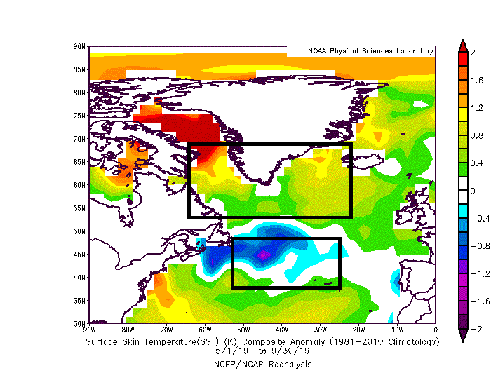
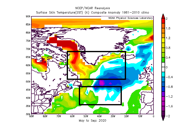
My Summer N. Atlantic SST = Winter NAO index, is 9-1-4 in the last 14 years. It was more than 1.5SD off last Winter, but the average SD is 0.55. It comes in at -0.15 for the Winter, about Neutral. (Warm upper box is negative, Cold lower box is negative). I would say that's -0.10 even.
-
November Medium/Long Range Discussion
StormchaserChuck! replied to WinterWxLuvr's topic in Mid Atlantic
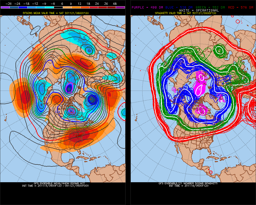
That's 582dm on Nov 21. even with a ridge over northern AK.. yuck. what a horrible Winter..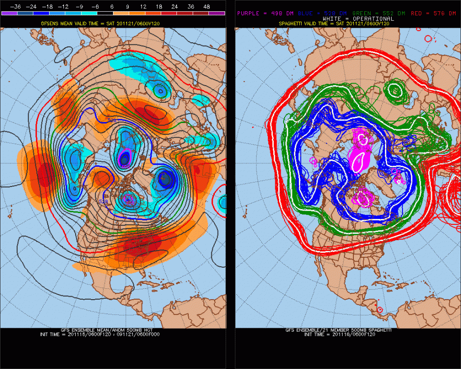
-
Our best hope this Winter is -EPO. It will snow during -EPO (<5")
-
I would think it would be odd for every storm to be a warm front during the Winter. But that is what the climate indicators are suggesting. No one thought it would be +NAO in the Winter for 34 straight months, so who knows... The La Nina looks uniform, which could hold that 35 and rain pattern through the Winter. (I already know it's going to be a warm March and April.)
-
2019 ENSO
StormchaserChuck! replied to AfewUniversesBelowNormal's topic in Weather Forecasting and Discussion
It seems that this one has the structure-orientation of a early peaker. (But its been overperforming so far). It's only Nov 15, so I wouldn't discount another cooler wave. It probably has 1 more wave cooler as the -3 comes the surface. -
November Medium/Long Range Discussion
StormchaserChuck! replied to WinterWxLuvr's topic in Mid Atlantic
Pacific is going to be -PNA all Winter, I wonder if that will create a window ~Nov25 - Dec 5(, in duality). -
2019 ENSO
StormchaserChuck! replied to AfewUniversesBelowNormal's topic in Weather Forecasting and Discussion
La Nina is really asserting itself in the pattern (look at the constant ridging north of Hawaii) http://mp1.met.psu.edu/~fxg1/ENSHGTAVGNH_6z/ensloopmref.html -
2019 ENSO
StormchaserChuck! replied to AfewUniversesBelowNormal's topic in Weather Forecasting and Discussion
I was really wrong about this La Nina, it's really asserting itself. It will be interesting to see happens going forward, I was always thinking it could be a long term dull pattern. It would make sense for an event, maybe El Nino, to follow it. -
-
Going to be tough with La Nina dominating many parts of pattern right now. QBO is unfavorable too, I think. (Something to watch is Nov-Dec '18 and '19 had the coldest Stratosphere ever for that time of the year going back to 1948. Should be interesting to see if '20 does it. And maybe '21 too.)