Daniel Boone
-
Posts
3,542 -
Joined
-
Last visited
Content Type
Profiles
Blogs
Forums
American Weather
Media Demo
Store
Gallery
Everything posted by Daniel Boone
-

January Medium-Long Range Discussion
Daniel Boone replied to Holston_River_Rambler's topic in Tennessee Valley
Larry in SE Sub and main Forum backed those findings with tons of Data. -
January Medium-Long Range Discussion
Daniel Boone replied to Holston_River_Rambler's topic in Tennessee Valley
If it gets to 8 we should then see a nice PNA Ridge set up. We really need those higher Lats in our favor as Coz was alluding to. That would help with the Southern trek and speed of Systems thus upping the ante of Big Dogs. If the MJO were to get stuck in the warm phases and blocking doesn't reset it could be another Flooduary. We do have a wildcard at least . The SSW. It should revamp the blocking. -
Yeah, it many times has the winning hand here but, pretty strong WAA at 850 will probably give it to the Hrrr, or a combination of both Models may be the route it takes.
- 372 replies
-
- 1
-

-
- cold
- arctic blast
- (and 1 more)
-
Gfs holds and has Snow NETN/SEKY and SWVA. 2-3" SEKY and SWVA. 10:1 Ratio.
- 372 replies
-
- 3
-
-
- cold
- arctic blast
- (and 1 more)
-
All Models were too high on forecasted lows and highs in snow covered areas. Snow cover will play a part.
- 372 replies
-
- 3
-
-
- cold
- arctic blast
- (and 1 more)
-
From what I can see, it's the only model with that extensive area of icing. The 0Z high res. Fv 3 has predominately snow in SEKY/SWVA. The 0Z 3k Nam as well. Fwiw, it may be right but, I've found the Hrrr has a bit of a warm bias in upper east TN and SWVA.
- 372 replies
-
- 2
-
-
- cold
- arctic blast
- (and 1 more)
-
January Medium-Long Range Discussion
Daniel Boone replied to Holston_River_Rambler's topic in Tennessee Valley
If you're right, going to be some missed or quickly changing forecasts. -
January Medium-Long Range Discussion
Daniel Boone replied to Holston_River_Rambler's topic in Tennessee Valley
Yeah, the -NAO leaving is the killer. -
Yeah, it definitely proved itself itr the last few Winters. Pretty much spot on in most cases.
- 372 replies
-
- 3
-
-
- cold
- arctic blast
- (and 1 more)
-
I'm expecting to get near zero again tonight, I know they are expecting SW winds to advect warm air, but SW of me for about 200 miles is snow pack all the way to Huntsville Alabama. I'm sure that distance of snow pack will have an impact on the temperature here all the way to Knox County and beyond. Exactly what I'm thinking.
- 372 replies
-
- 3
-
-
- cold
- arctic blast
- (and 1 more)
-
URGENT - WINTER WEATHER MESSAGE National Weather Service Morristown TN 318 PM EST Wed Jan 17 2024 TNZ018-041-043-045-047-072-074-087-VAZ001-002-005-006-008-181000- /O.NEW.KMRX.WW.Y.0003.240119T0000Z-240120T1200Z/ Johnson-Cocke Smoky Mountains-Southeast Greene-Unicoi- Southeast Carter-Blount Smoky Mountains-Sevier Smoky Mountains- Southeast Monroe-Lee-Wise-Scott VA-Russell-Washington VA- Including the cities of Doeville, Mountain City, Neva, Shady Valley, Trade, Laurel Bloomery, Hartford, Cedar Creek, Erwin, Unicoi, Limestone Cove, Hampton, Cades Cove, Elkmont, Gatlinburg, Citico, Coker Creek, Rose Hill, Big Stone Gap, Norton, Wise, Coeburn, Appalachia, Pardee, Hiltons, Hansonville, Lebanon, Dye, Castlewood, Honaker, Rosedale, Benhams, Bristol VA, and Abingdon 318 PM EST Wed Jan 17 2024 ...WINTER WEATHER ADVISORY IN EFFECT FROM 7 PM THURSDAY TO 7 AM EST SATURDAY... * WHAT...Mixed precipitation expected. Total snow accumulations of up to 4 inches and ice accumulations of a light glaze. Winds gusting as high as 45 mph. * WHERE...Mountains of East Tennessee and southwest Virginia. * WHEN...From 7 PM Thursday to 7 AM EST Saturday. * IMPACTS...Plan on slippery road conditions. The hazardous conditions could impact the morning or evening commute. Gusty winds could bring down tree branches.
- 372 replies
-
- 1
-
-
- cold
- arctic blast
- (and 1 more)
-
Just read wwa for Swva and tenn mountains. Saying up to 4 inches of snow and a glaze of ice. That's Winter Storm Criteria actually. If I were the forecaster there now, I'd go with a Winter Storm Watch and a WWA.
- 372 replies
-
- 6
-
-
- cold
- arctic blast
- (and 1 more)
-
January 15th-17th 2024 Arctic Blast/Snow Event
Daniel Boone replied to John1122's topic in Tennessee Valley
Made it to 20 here so far . Got a report from Northern Lee County on the Wise Plateau that Keokee had received just under a foot from this System. -
Yeah, I suspect they'll beef back up if System doesn't trend further north.
- 372 replies
-
- 2
-
-
- cold
- arctic blast
- (and 1 more)
-
Big difference in Temps in east Tn in relation to snowpack. Check out the difference in lows in the Johnson City area compared to Knoxville.
- 372 replies
-
- 2
-
-
- cold
- arctic blast
- (and 1 more)
-
January Medium-Long Range Discussion
Daniel Boone replied to Holston_River_Rambler's topic in Tennessee Valley
Yeah, definitely feeding off each other( PDO, MJO etc). If we can get some strong convection fire near the Dateline it could negate the MJO warm phases somewhat. Problem is, the domino effect of pressure from the dominant MJO is probably hampering convection development along Dateline. If we could get the MJO to the Dateline with little convection in the IO , that may reverse the pattern of that. Seems PDO has became closer to neutral last I checked so, may have a decent shot. If so, there is a possibility of a monster Snowstorm ( Maybe historical)for the area somewhere from mid February to mid March I believe, particularly if the SSW does it's thing with the NAO. -
Still thinking mainly frozen NE sections as enough mixing and lifting of deep Valley cold should drop incoming SW WAA to below freezing all levels from about Rogersville to Kingsport North. Probably mix from there south through Knoxville. With all the snow pack to our wsw it is possible the snow line could be further south as the cold lower air will lift as it is pulled ne by the System. Then there's a backlash that may get at least northern sections. Just my antique 2 cents.
- 372 replies
-
- 1
-
-
- cold
- arctic blast
- (and 1 more)
-
January Medium-Long Range Discussion
Daniel Boone replied to Holston_River_Rambler's topic in Tennessee Valley
Yeah, MJO looks strong in warm phases. Those heated waters out there just continue every year now. Really don't know the exact cause. Could be underwater Volcanic activity. Some speculate a byproduct of Climate change. Whatever the reason, it is what it is and it continues to lean Eastern US Winters on the overall mild side. -
January 15th-17th 2024 Arctic Blast/Snow Event
Daniel Boone replied to John1122's topic in Tennessee Valley
Currently 3 here and cloudy with a few flurries . -
Currently 3 degrees here.
-
Jan Medium/Long Range Disco 2: Total Obliteration is Coming
Daniel Boone replied to Jebman's topic in Mid Atlantic
Lol, yeah good to go,lol. -
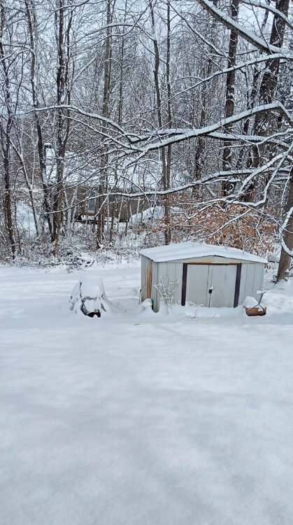
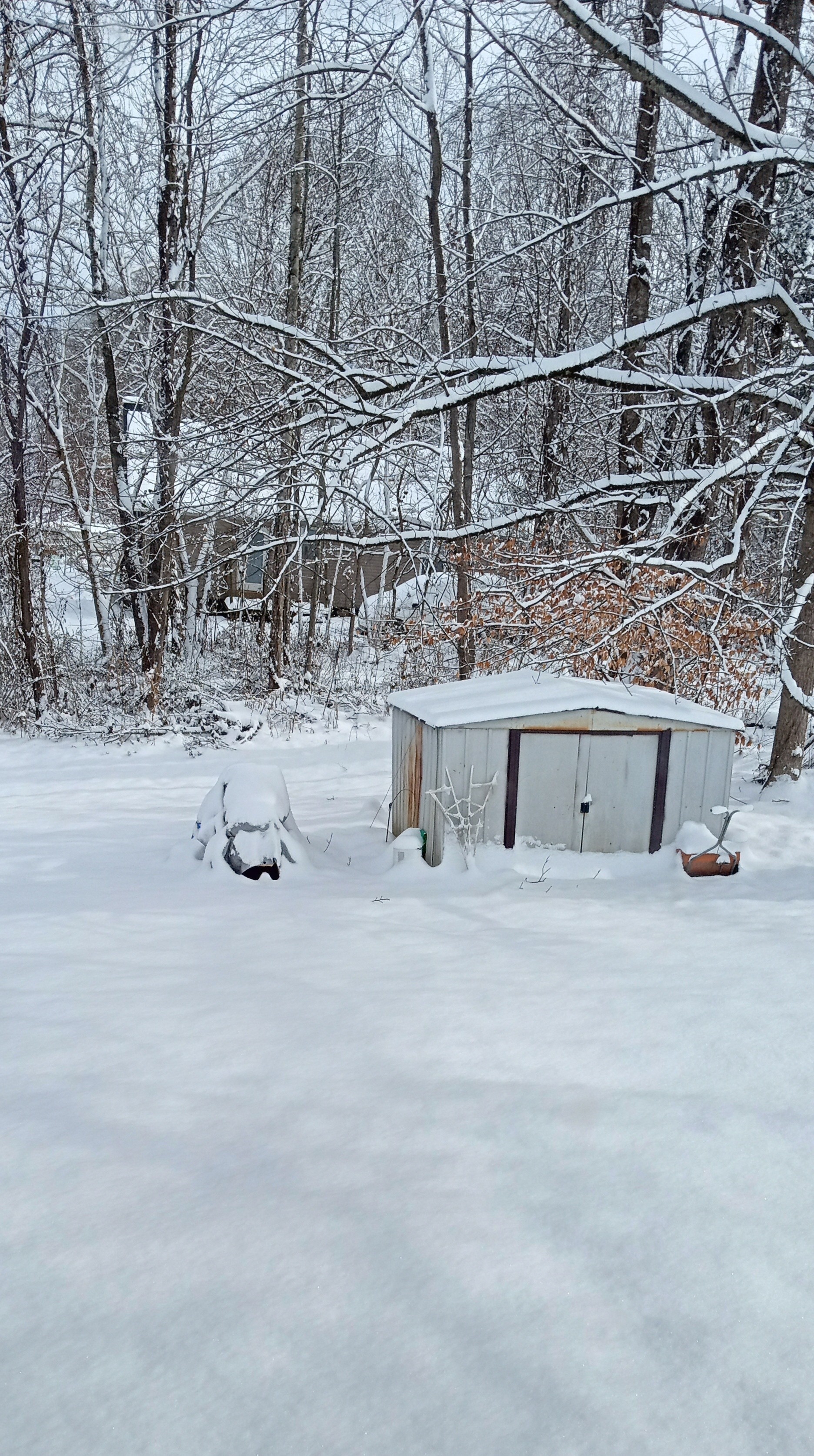
Jan Medium/Long Range Disco 2: Total Obliteration is Coming
Daniel Boone replied to Jebman's topic in Mid Atlantic
Out my back window. 7.2" Storm Total.