

*Flash*
-
Posts
925 -
Joined
-
Last visited
Content Type
Profiles
Blogs
Forums
American Weather
Media Demo
Store
Gallery
Everything posted by *Flash*
-
I was about to say. Give me some 2003 or 1988 juice with that.
-
Agreed. MJO phase and strength matters, but ePac anomaly placements, polar strat evolution, arctic blocking…they all have a say too. Right now, my concern is not in winter feeling like winter rest of the month…but rather if we'll get future troughs to dig deep and sync with the STJ. The emergence of fantasy “big dogs” gives me some hope.
-
BAM doing some painful backtracking on X this morning. Yikes!
-
If a Modoki situation emerges in the Pacific, I wouldn't be surprised to see early March* open for business in the upper south, though obviously this is 100% speculation. Overall, I think confidence is growing the second half of winter will be more active. *I'll have to review the CF6s; however, if memory serves, I think March 1-15 is better for snow in Nashville than December 1-15. I know climo winter is December 1-February 28/29, but I think calendar window makes more sense in terms of our snow window.
-
The BNA UHI is getting worse at a rapid rate, so I think assessing rural areas for historical rankings makes more sense at this point. In the coming years, I expect BNA to see more top 5 rankings while outlying areas only crack the top 10.
-
That 0z Euro run was essentially the prophetic manifestation of Lucy and the football. Didn’t mean to call it so soon. Not getting discouraged yet, especially since modeling is struggling more than it has in recent years.
-
Phew, those contours are thicc. Nice to see a clown map on the board.
-
12z GEFS went colder as well. Solid trends though I expect Lucy to come out at 18z or 0z.
-
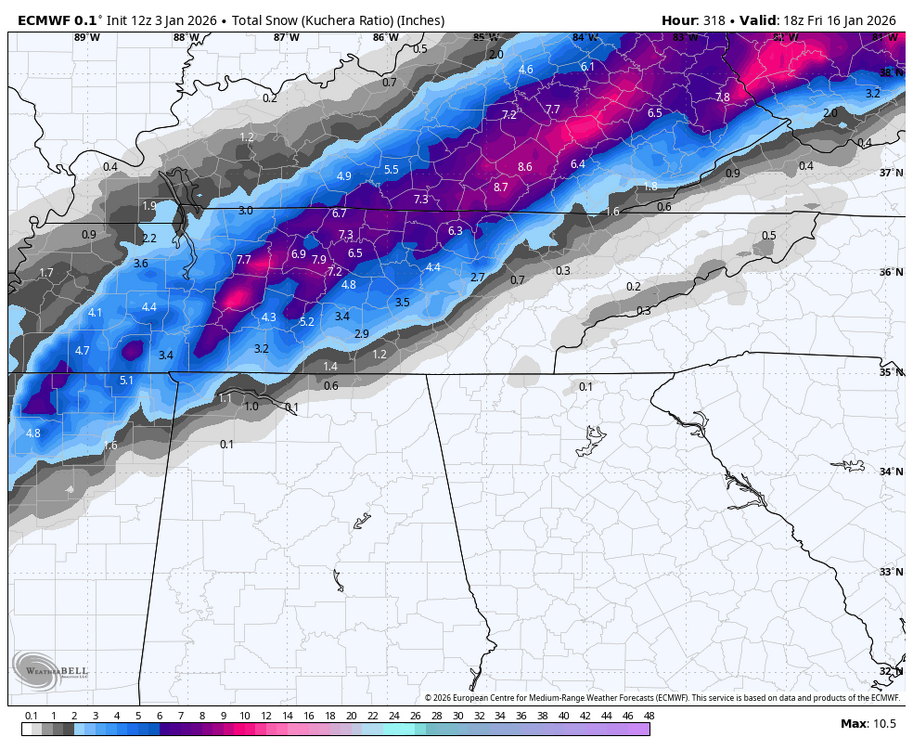
I know it doesn't impact east TN, but I'll take what the 6z AI Euro is suggesting for 1/13/26. Decent 2-3" for west/northwest middle TN on that run. Hopefully some mischief is being sniffed out here.
-
If this ends up being another I-44 winter, this will be one of the most unique ways we've gotten there.
-
BAM doing [what appears to be] some backpedaling this morning. Could this be the beginning of #wintercancel2026? Facetiousness aside, I get why transparency is important when discussing risk/what could go wrong, though if the 0z Euro Det is on to something, then yeah, extended PV placement will be a concern and thus, the alignment of historically favorable teles would simply result in seasonably cool as opposed to substantial cold. We're still in the land of monitoring trends so hopefully people don't overreact today. If I was a betting man (thank God, I am not), I would be tempted to take plus money on the bulk of my 2025-26 wintry precip coming via overrunning. Knowing our mean luck, by the time all things MJO, AAM, etc. sort out, we'll have the SE ridge flexing its muscle again. BAM Weather on X: "Here is a PERFECT example of how a very ideal blocking pattern can yield nothing in return for cold. EPS and AI on the top 10-15 day GEFS and AI on the bottom 10-15 day Aside from the EPS AI the other 3 datasets see no true cold air and the reason for the DESPITE the -EPO/+PNA https://t.co/mAcdc7fS8R" / X
-

December 2025 Short/Medium Range Forecast Thread
*Flash* replied to John1122's topic in Tennessee Valley
Yeah, I doubled that departure at my location. A tad disappointing but from what I understand, anything between -2 and +2 is technically 'average'. No question, the warm spell overachieved for west and middle Tennessee and left the greatest impression on the CF6. The below departures to our north and east seem to correlate well to areas that saw snow cover/accumulations during the first half of the month. Moving forward, we'll have to remember the signals surrounding the month since they join a case study on what flat troughing in December can produce for our subforum. -
I hate the monkey wrench that the MJO seems to be each year. I subscribe to the notion it's not a matter of if, but when the -EPO/+TNH takes its hold over the conus pattern. BAM teased January 2014 in a recent Tweet. My initial reaction...slow your roll. 'TIs a dangerous analog to casually reference. Best case scenario, I suspect January 2026 could be a poor man's version of that month. I have window size concerns once the cold arrives but can't complain about the timing.
-
I like to consider what drivers are quantifiably most anomalous. Magnitude generally matters. If the MJO is COD and you have a blocking tele that is extremed to one side of the ledger, I tend to give more credence to the latter. Granted, I still have much to learn when it comes to analyzing the atmosphere, especially 'cross-the-globe signals ending in torque or momentum. Three years in met school back in the day and some of the stuff we're talking about wasn't even a topic of conversation.
-
Per recent verification scores, it's a tad concerning the 0z GFS is more pro-cold than the 0z Euro, granted one run doesn't make a forecast. I imagine models are picking up on a transient warm spell before the hammer drop. As Carver noted last week, it just takes a few members to skew the batch. Still scratching my head why CPC is so warm for in their extended outlooks. Also, 'tis interesting amidst the flip-flopping, there are signs a +TNH pattern may develop. That in tandem with a -EPO can work for most of the forum, though with the SE ridge risk, I prefer the 'old school' -NAO/-AO being a more dominant driver. At least the southern jet looks cooperative. Preferably, I like average to slightly below average precip for January/February given what that can imply. I recall past Nina winters that went super zonal in January. Doesn't look that way this go-around.
-
CPC doing CPC things today.
-
Good update, Holston. I could be overly optimistic but it wouldn't surprise me if January fun 'n games continues into the first half of February. We've finally killed the heat dome in our state. Waking up to 20s never felt so good! On a separate note, I can't upload any media over 3.7 kb on this forum which essentially defeats the purpose. I'm not sure why my issues are confined to this site only. Anyone else having that problem? I'll see if I can clear some things to fix the issue. Not super tech savvy.
-
Man, those GOA anomalies seem juiced, granted, it's nice to see blocking on both sides of the map. Not sure if Hudson Bay activity will have any impact on NAO placement. Either way, with climo on our side, this could be a great example of how you can still score at this latitude even without cross-polar flow.
-
Props to you. I take Christmas down mid-January and then leave the 'winter' vibe items out until...basically calendar spring. Winter is my favorite season IF it cooperates.
-
When the fun and games begin, it wouldn't surprise me if my area was outside where the best entrance/exit jet regions set up. I know it's far out but that's just my gut looking at the upper air and beyond. Growing up I recall several storms that organized just in time for middle TN to pick up a few inches before exploding into something more east of the Apps. As it was said earlier today, the pattern has an old-school vibe to it.
-
If you're in the mid-Atlantic, you're sittin' right for the first time in a long time. Pattern screams potential especially for those in decadal snow drought territory. If there ever was a time to root for our coastal friends, it's now.
-
In case you haven't seen DT's overnight vid, worth the watch. 17:26 is worth screen-shotting for posterity...
-
For real. I'm blue da ba dee da ba di!
-
Historic Tennessee Valley Cold, Snow, and Ice Events
*Flash* replied to Carvers Gap's topic in Tennessee Valley
Not exactly pertinent to our area, but if you pause the video below at 1:02 (or simply note the thumbnail), you get one of the biggest swings and misses in the history of 30 Day Temperature Outlooks. This forecast ran for the NYC area on 12/24/1993. God, I miss this era... -
December 2025 Short/Medium Range Forecast Thread
*Flash* replied to John1122's topic in Tennessee Valley
Why do I feel dirty reading this? Probably just the mountain.


