*Flash*
-
Posts
925 -
Joined
-
Last visited
Content Type
Profiles
Blogs
Forums
American Weather
Media Demo
Store
Gallery
Everything posted by *Flash*
-
Seems to me this winter (and I know we're only half-way through) may go down as a textbook example of all the things that generally go wrong in a Nina/weakening Nina setup. The December Chinook, the historic cold in Alaska, misplaced Atlantic blocking, the stubborn Great Lakes lows, so many things have contributed to split flow and lack of phasing. You can sort of see the past 30/40 days how one issue has played into the next, even through the pattern resets. We have modest cold air supply rest of the month. Just have to hope the river and flop work in our favor regarding precip and timing. As for the weekend threat, I can't recall such a huge whiff on American models, notorious as they may be, within 24-48 hours. I try to not let recency bias get the best of me, but I lack relative remembrance. Truly, the absence of overhead blocking played a huge role in the weekend threat evaporating and will be a legacy to the archive. We've seen this storyline before many times, so it confuses me why so many neglected the writing on the wall. Kinda feel for our Piedmont brothers. They spew a lot of crazy stuff over on Southern but they're long overdue. Rooting for you, @GaWx! Not to sound to straight-forward but send pics if things out for you.
-
Indeed, we have pivoted from needing westward trends to cooler trends. Still have my eye on the plateau tonight. National guidance is modest, but those high-res short-term models are suggesting multiple inches in some parts.
-
Bobby Boyd has been previewing a freezing rain/ice signal for BNA the past 24 hours. Granted, it's 10 days out; however, it makes sense there could be mischief around this time.
-
Also, for the record, I'm really bummed seeing the amount of pro/TV/AMS mets plastering eye candy snow maps without beneficial context to the public. I'm not looking to purify my feeds per se, but if I see a local met or influencer page not communicating within due diligence, my tendency to unfollow/snooze. Weather is more enjoyable without the bias. Hype is fine once confidence is high enough to support it.
-
It's been a groan fest for most of the decade east of the apps. TN Valley has been way more fortunate the past 5 years.
-
Still too much model variance to be confident in any solution. Hopefully, that changes in 12-24 hours. December 2017 might have track comps but wasn't that storm more amped? That low was stronger if I recall.
-
Good trends. Still rooting for more of a western adjustment. Should have a grasp of my travel plans within the next 24-36 hours. What a day of runs!
-
Yeah, I’m rooting for this in hope to maybe chase on the plateau.
-
HRRR/0z NAM Fri/Sat s/w…I have no choice but to root for thermal compliance and more juice. I’ll take an appetizer inch at this point. Would feel better if I lived in central KY. Will be interesting to see how each wave affects the next.
-
Who knew the secret to enjoying winter is to have a beach house on the panhandle that you can visit in July as well as January. Smh.
-
That is a potential horror movie waiting to be written.
-
18z NAM would be great for west/middle TN especially north of 40, but with so many outcomes on the table, I'm not sure where to lean right now.
-
SouthernWx is taking James Spann to town over his Euro-AI post on social media last hour.
-
Really REALLY rooting for a western adjustment. No weekend hope for my locale..but given the timing, I would love to take a plateau jaunt to a place that benefits from typical orographic lift. Monterey/Crossville...preferably no more east than that.
-
PSA Reminder: All models are wrong, some are...that's right...useful. Even clown maps can be beneficial in signaling a storm or pattern's ceiling, laugh at them we may. Sometimes, we just got to zoom out and appreciate we're smack-dab in the best 7-month stretch of the year (10/1-4/30). Plus, we're looking at net positive trends approaching peak winter climo. That should keep our forum hopefully optimistic the next few weeks, barring anything unforeseen.
-
As long as it doesn't involve 'orange' juice (I.e. AN) on the temp-side, I'll take whatever the STJ can offer. CMC Ens #12 and #16 look pretty darn good.
-
Agreed. I feel moderately secure in the temp department, which is more often the bane for our tracking pleasures. Drought is the fly in the ointment as has been pointed out. Just give me some moisture fetch somewhere and I'll take my chances on high ratios...or if my locale can't score, cook up some 3-6" action up on the plateau and I'll take the fam to Monterey. Seriously, just give us some flakes, Mother Nature. My kids literally asked me this morning if I could ask Siri for some snow. I cried a little inside. I so wish it was that easy.
-
Will be interesting to see if our forum sees one last hurrah during the second week of March. We've seen it before!
-
I don't have anything meaningful to add right now...

-
https://giphy.com/gifs/hd-quality-TJPQBOfPGpgmQ
-
i agree. Gotta like the fact we have two shots at a decent dog. Hopefully, the entire viewing area can get at least to seasonal climo snow totals before February. Might be too much to ask...but suddenly the ceiling is there.
-
Thanks for the swift response, Coach. I was kinda picking up on this vibe. Unless western trends are noted, it sure seems I'll need to head east at some point this month. Rooting for the ICON!
-
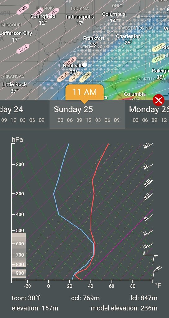
Do you have charts for Nashville?
-
I was about to say. That 12z suite is looking...sweet! Plus, DT just updated his FB profile pic to Snow Dog Holmes! Always a good sign... #woofwoof
-
More west/southern digging…trends I’m rooting for!