*Flash*
-
Posts
925 -
Joined
-
Last visited
Content Type
Profiles
Blogs
Forums
American Weather
Media Demo
Store
Gallery
Everything posted by *Flash*
-

December 2025 Short/Medium Range Forecast Thread
*Flash* replied to John1122's topic in Tennessee Valley
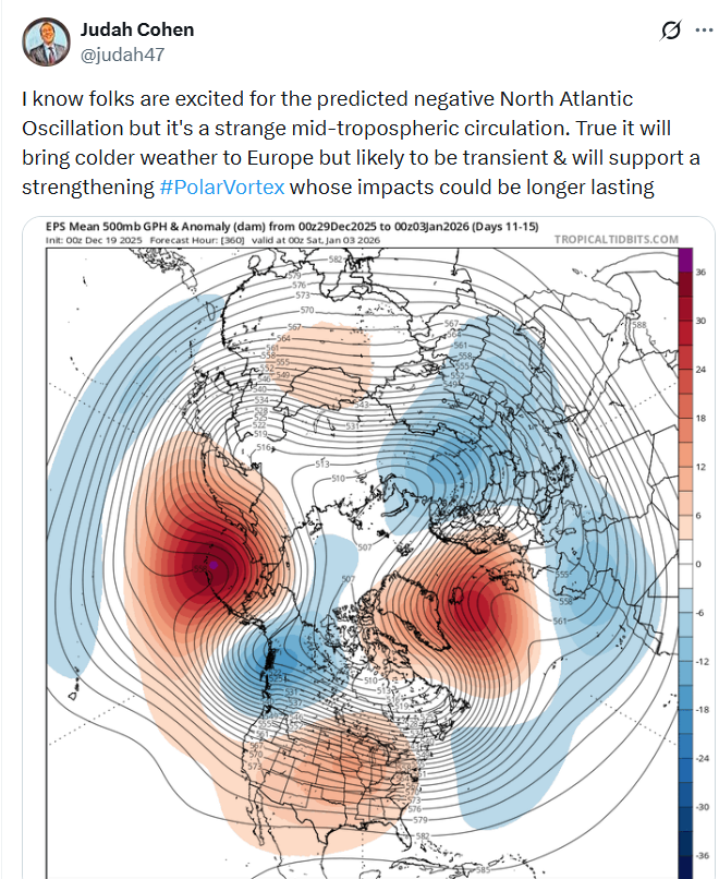
Seeing the 12z EPS/GEFS agree on week 2 cold and a +PNA emerge on modeling today felt like a Christmas present from Mother Nature. How quickly things can change in our field of interest. -
December 2025 Short/Medium Range Forecast Thread
*Flash* replied to John1122's topic in Tennessee Valley
Merry Christmas to you! I agree 100% with this post; hence, why AmericanWx has become my 1a forum over the years. Understandably, for snow weenies at our latitude, we must contend with FOMO angst. Unless you're a FL/TX/CA transplant, warm holidays are hardly enjoyable, like a warm beer on a hot day. This riding 6 weeks of cold/dry and near misses to our north. 0.2" of snow IMBY since November 10. Drive 3 hours north and you get 50x. Say what you want about climo, but that's tough sleddin', pun intended. Like New Years resolutions, there's hope with a side of dopamine in anticipating a reset/workable pattern within 14-21 days. As long as we can get a quality two-week window during peak snow climo, I won't complain. Middle TN, in particular, has seen this work for several winters this century where DJF skews mild, but we somehow sneak to average snowfall or higher. Having just been discharged from the hospital with our last little Bag Fry, I've had time to reflect back to exactly 10 years ago when we were gearing down for our first. Unlike this month, December 2015 was pure torch with the pattern almost entirely ENSO dominant, but like this month, we were begging for a sign. The morale of the story has been alluded to in recent days with all the Grinch posters going to town. Even with the atmosphere, what goes up must come down. The question isn't 'if', but 'when'. Ask yourself, starting December 1...would you rather go cold/warm/cold or warm/cold/warm? We'll see how this all shakes out.
-
December 2025 Short/Medium Range Forecast Thread
*Flash* replied to John1122's topic in Tennessee Valley
I respect the knowledge base for sure. Just not always the way its conveyed or responded to when counters are presented. Either way, I believe it's wise we maintain a diverse portfolio of follows this time of year. Lot of credible voices out there, not all are doom and gloom on this first day of winter. -
December 2025 Short/Medium Range Forecast Thread
*Flash* replied to John1122's topic in Tennessee Valley
Happy Winter Solstice, everyone?
-
December 2025 Short/Medium Range Forecast Thread
*Flash* replied to John1122's topic in Tennessee Valley
This look could be a lot worse.

-
December 2025 Short/Medium Range Forecast Thread
*Flash* replied to John1122's topic in Tennessee Valley
Curious...has our area ever done well with a strong PV before? Seems the -NAO may not be enough based on what JC is suggesting here...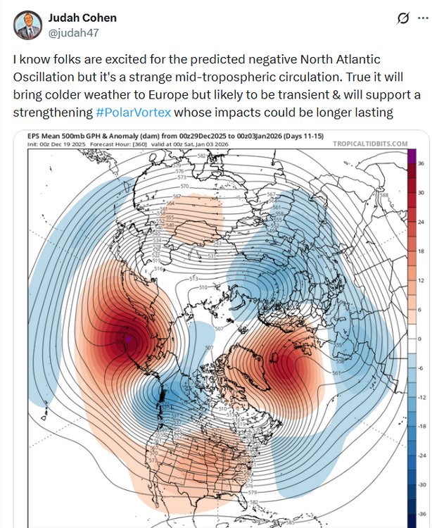
-
December 2025 Short/Medium Range Forecast Thread
*Flash* replied to John1122's topic in Tennessee Valley
Hearing you say that gives me bad 2016-17 vibes. Awful winter but there were some breaks if you include March. -
December 2025 Short/Medium Range Forecast Thread
*Flash* replied to John1122's topic in Tennessee Valley
Glass half full people be like…just in time for peak snow climo at our latitude. Nice… -
December 2025 Short/Medium Range Forecast Thread
*Flash* replied to John1122's topic in Tennessee Valley
Yep! If we can move that darn pig, chances are things will get better. #suey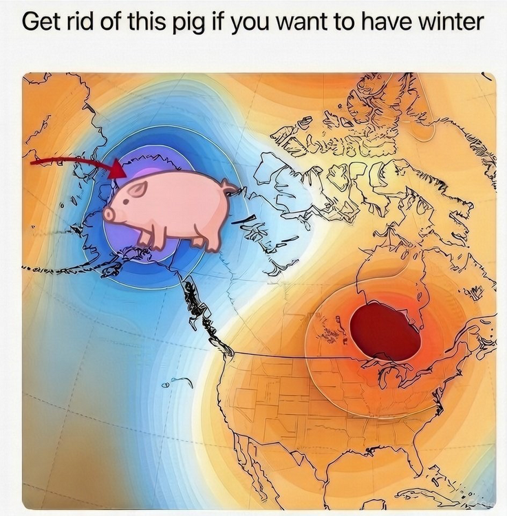
-
December 2025 Short/Medium Range Forecast Thread
*Flash* replied to John1122's topic in Tennessee Valley
I remember this storm. I was in 3rd grade. About 6-8" in Brentwood but the wind was howling which led to snow drifts up to my waistline in places! -
December 2025 Short/Medium Range Forecast Thread
*Flash* replied to John1122's topic in Tennessee Valley
I think the January thaw can be overly used sometimes, almost in almanac-y fashion. Even the best winters had their patented patterns relax a time or two; granted, I get how a transition into pause can be unsettling. Apart from present timing, I'm not bummed about a reload due to its necessity and how much we've historically benefited from them. Assuming the upcoming warm spell is overhyped, I could see monthly temps verifying close to average for most, maybe a little above average for west/middle TN. Also, I agree with the idea we'll flip cold at some point in January. May not be seasonal climax level but perhaps the start of a stairstep into glory. I know for me, times like these latch my hopes to analogs. For instance, if you like second half loaded winters, our latitude is a place to be as we've seen plenty of them the past decade (I.e. 2014-15 and 2020-21). Those examples saw some gnashing of teeth in the first half before things went gangbusters in the second. Not to suggest this winter is like those winters or anything we've seen the past decade. Certainly, this year feels unique already with our closest saving grace being on the Atlantic side, not the Pacific. Go back and review past winter threads and you'll see how the PNA/WPO/EPO were highly discussed along with the MJO. Per Michael Scott, oh, how the turned tables. Whatever transpires in the short term, let the record show I don't ask for much but amplification, volatility, and any west-based retrograding on those strat/Atlantic teleconnections. Winters with trackable systems within multi-week ebb and flows are my favorite. -
December 2025 Short/Medium Range Forecast Thread
*Flash* replied to John1122's topic in Tennessee Valley
Yeah, they aren't as torchy up close. All the Heat Miser posts going around...people sometimes lose sight of what is based in probability versus departure. We're so tailored to extremes if we can't have a blizzard, we want the beach. No one wants to talk about 41-41 weather that lacks a high draft pick and no guarantee of the playoffs. I could be wrong, but I think we'll see a return of amplification in January even if it's not so defined right now. As for 11 days from now, I really don't anticipate Christmas Day being a redux of 2016 or 2021. Both those dates had highs well into the mid/upper 70s around these parts. The latter example had that light switch turn around New Years when we went severe weather mode to winter weather mode in a few days. I remember that stretch fondly as my wife and I were getting Jubilee moved from the Centennial NICU to the Vanderbilt NICU. I had shorts and sweaters packed! xD -
December 2025 Short/Medium Range Forecast Thread
*Flash* replied to John1122's topic in Tennessee Valley
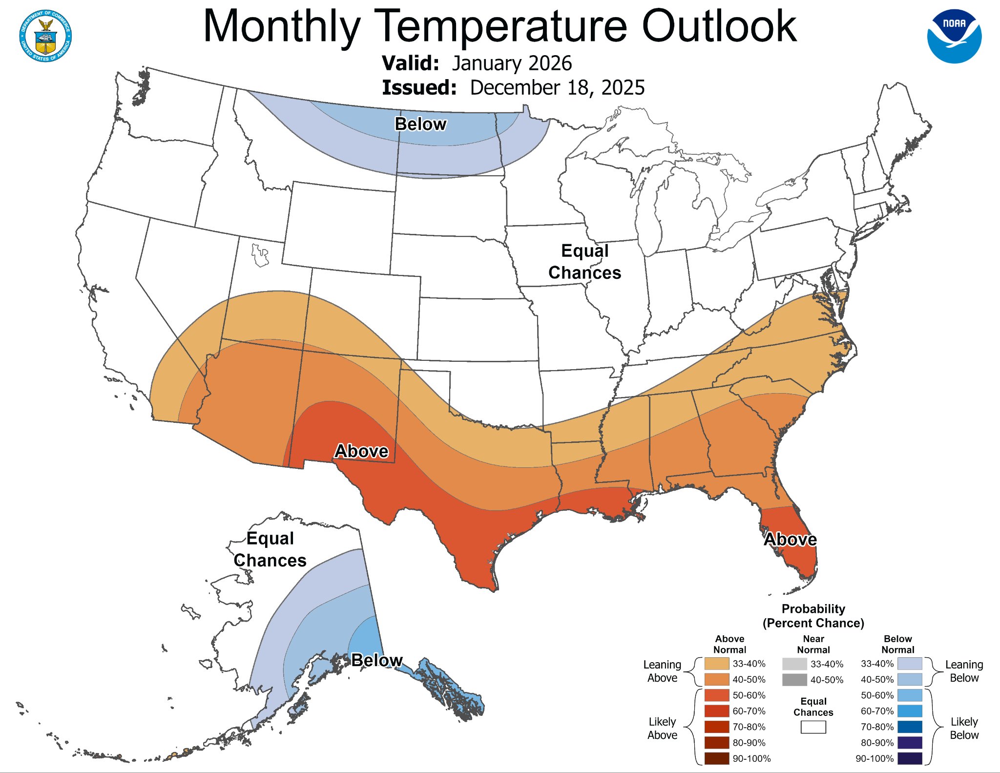
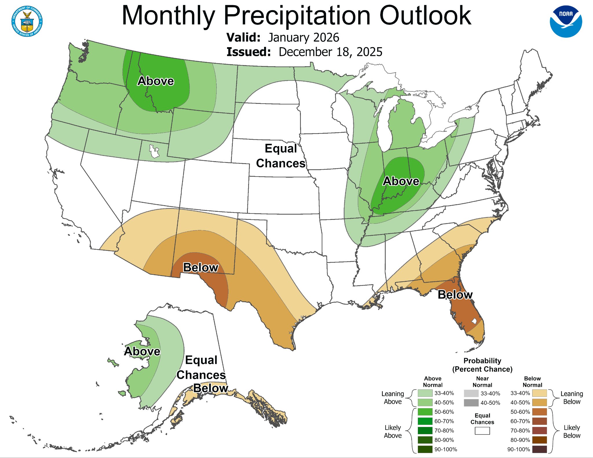
Leaving this as more of an open-ended question. Are decadal warming patterns being over integrated into seasonal outlooks and extended D14-30 forecast windows? The notion pops up every October for me when I review NOAA's winter outlook and note how so much of the country is plastered in orange and red. Not a hypothesis per se, but a suspicion about warm biases in the micro overly influenced by climate progression at large. Probably way more case by case then I'm making it, granted, the way my memory interlocks with recent experiences, it seems more torch previews have needed scale backs than the other way around. -
December 2025 Short/Medium Range Forecast Thread
*Flash* replied to John1122's topic in Tennessee Valley
A bit more bleak for west/middle TN these days. Hoping some hope can pop onto the scene during this ROM torchfest. -
December 2025 Short/Medium Range Forecast Thread
*Flash* replied to John1122's topic in Tennessee Valley
Yeah, that SOI sauce be crazy. As some have mentioned, the devil is in the latency of effect, but to what gives us stronger amp, we should generally root for. On an unrelated note, what are our thoughts on the second half of winter? I got one more bag Fry set to arrive on 12/17/25 so I'll be grounded from chasin' for 6 weeks (wife can't drive post c-section). Come Groundhog's Day, I'll be able to get back on the road and potentially bring my 10-year-old with me. -
December 2025 Short/Medium Range Forecast Thread
*Flash* replied to John1122's topic in Tennessee Valley
Truth. A hot thread during winter is generally a great thing! -
December 2025 Short/Medium Range Forecast Thread
*Flash* replied to John1122's topic in Tennessee Valley
I'm refusing to get my hopes up though the maps look pretty. Per this run, I imagine there will be gnashing of teeth in metro. Glad I chose the W/NW side of town to dwell. -
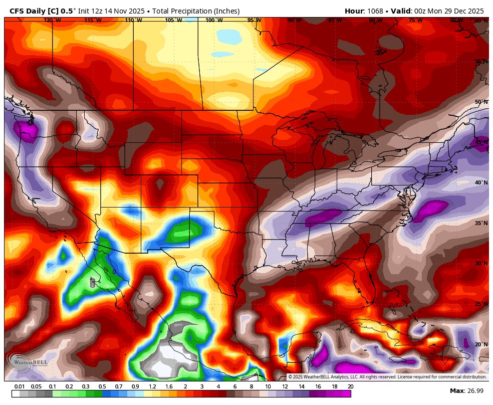
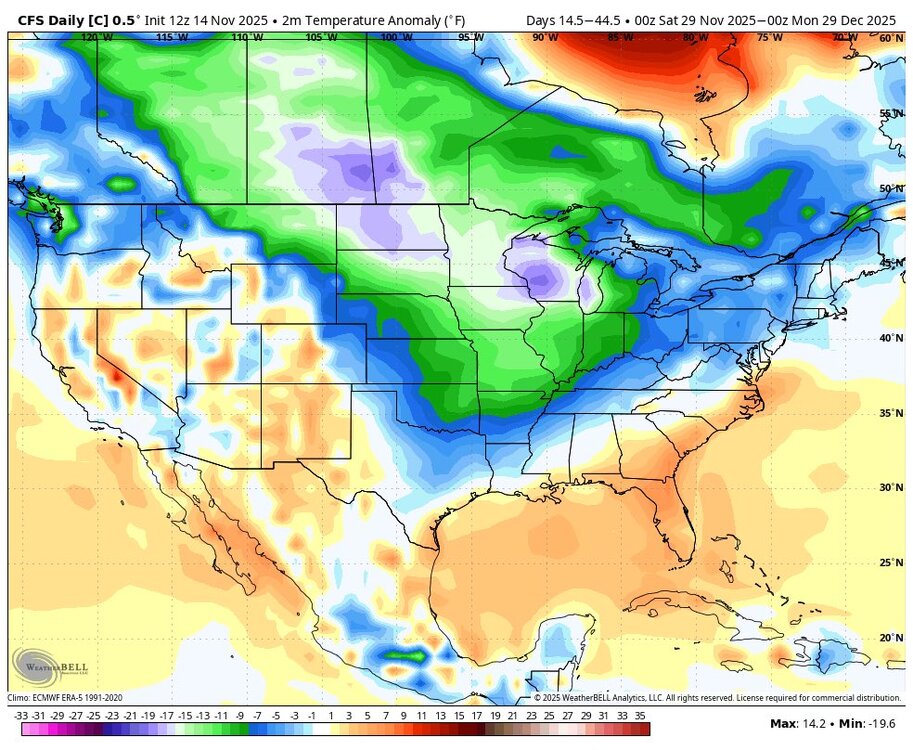
If we can get the cold to cooperate next month, it's hard to see a scenario in which most of the forum doesn't score. Diggin' the high precip signal on the CFS. Shouldn't be any shortage of trackable systems to close out the year.

-
So, my wife didn't capture it...but as this vid was recording, our 16' diameter trampoline went airborne behind the house into an open lot ~100 yards away. It was completely shredded upon finding it the next day. Thankfully, our only house damage was to our chimney cover. Still, there were several downed trees, some clearly by lightning strikes, and many disheartened children realizing their playgrounds are now rubble. Santa has time to come through though! Nashville SevereWx Storm Coverage Replay:
-
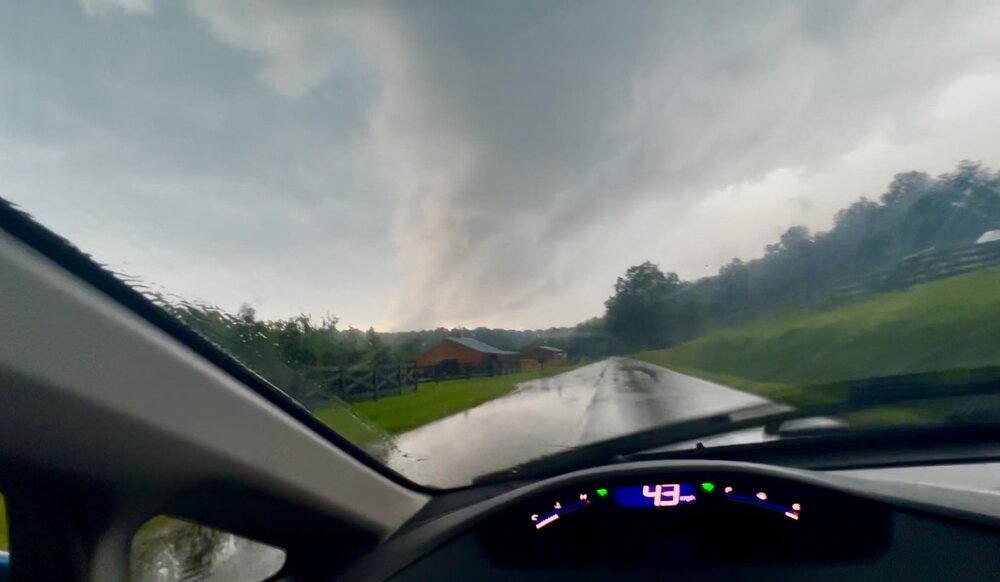
My hometown got crushed by the severe storms today. I didn't take the photo below but was parked within the hail core. Got trees split in the backyard I'll need to clean up tomorrow. Gotta get my kiddos a new trampoline too.
-
Shades of 2010-11 almost. These days, if you give me a pattern evolution supporting 66.67% of calendar winter as actual winter, I'll take it. No questions asked.
-
Bookmarking this for reference. Boy, what I'd give for this look in a couple months!
-
I can’t say I disagree. Sorry, @Carvers Gap, I know this doesn’t help with your latest inquiry.
-
I’m worried about this year’s hurricane season, ya’ll… https://www.facebook.com/share/v/1CDF5AFnTR/?mibextid=wwXIfr
-
About a half mile from Hwy 7 approaching Santa Fe yesterday. Thankfully the tornado that trigged the warning had lifted by this point, but you can still see the rain curtain/hail shaft!