*Flash*
-
Posts
925 -
Joined
-
Last visited
Content Type
Profiles
Blogs
Forums
American Weather
Media Demo
Store
Gallery
Everything posted by *Flash*
-
Oh no. Hate speech! Jk, jk.
-
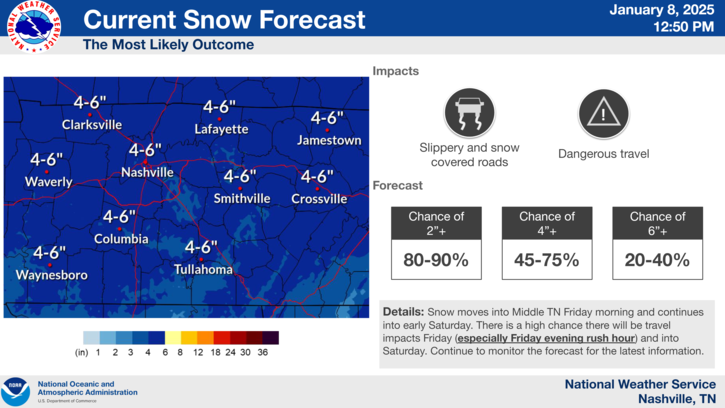
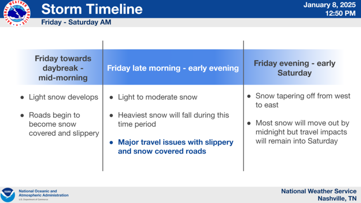
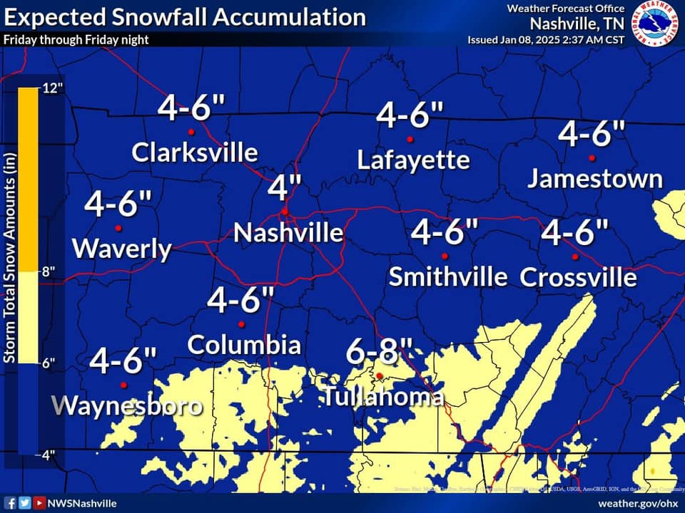
Nice graphics by OHX...
-
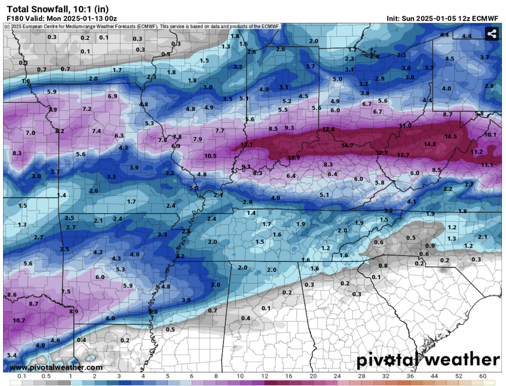
Didn't see this posted earlier so figured I'd share for archiving purposes. I think totals are a bit high for northwest suburbs unless I'm missing something.
-
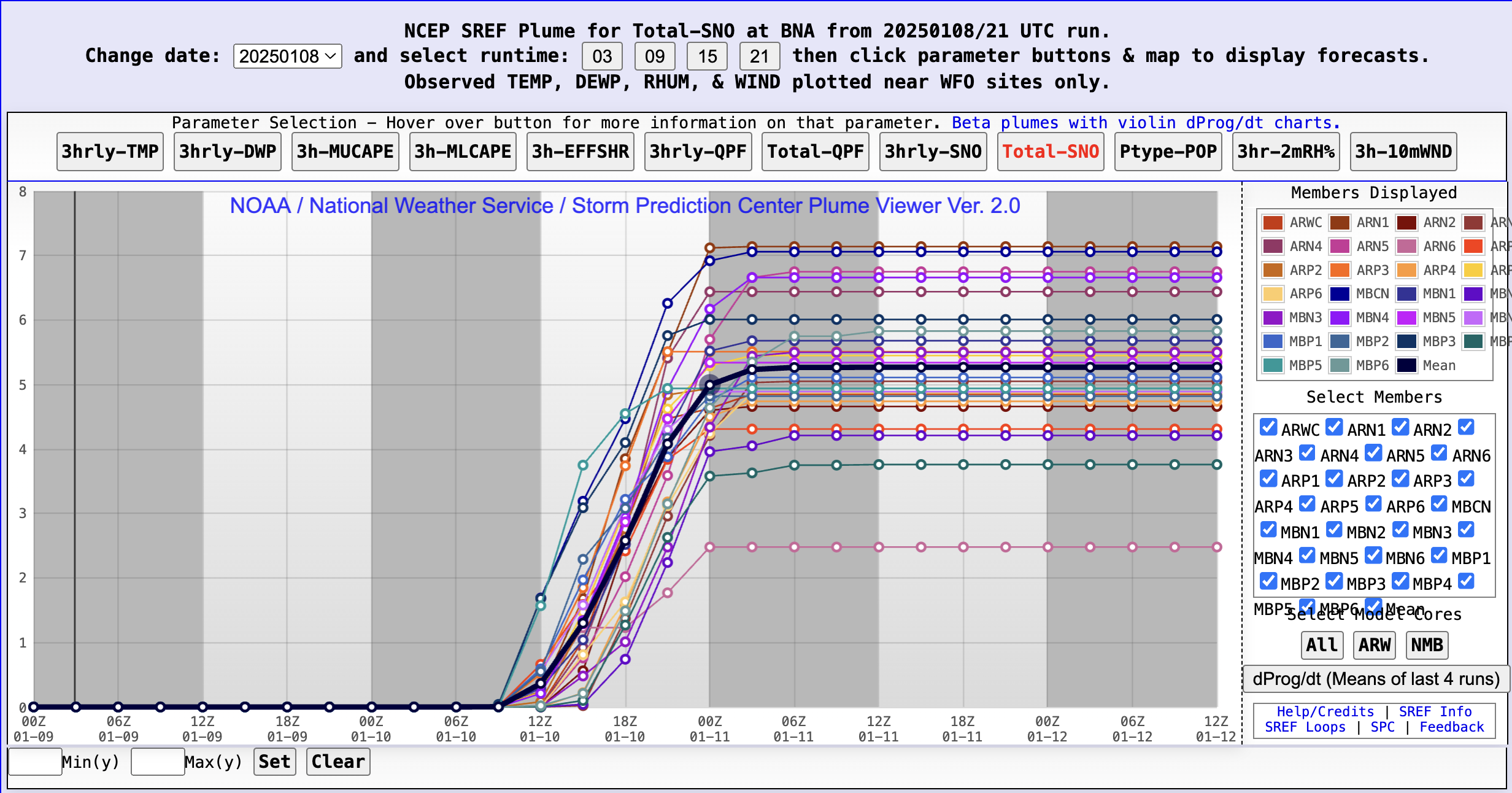
Yeah, it feels weird saying but I’m not sure I’m buying the Euro at the stage. Almost to the 60 hour threshold so hopefully higher resolutions will start to unveil a clearer picture. FWIW, SREF Plumes have a 3.22” mean for BNA.
-
Save that for the archives. A Code Red for the entire midstate is a rare gem.
-
Working remote today per my boss’s request as the black ice was enough to cancel several schools in my area. Freezing temps have persevered the powdered dusting we received yesterday. My kids’ faces say it all. Is it Fryday yet?
-
Cheers! *clink* The dad joker in me approves.
-
Gorgeous vorticity. That’ll do indeed.
-
The temperature at my location is depressing (pushing 50), though I will say we've been experiencing a ton of thunder and lightning. More than I expected.
-
I agree. I feel better about recent trends and at least being close to appreciable snow accumulation. The thermal details will sort themselves but I do think we have a genuine 'look ahead' within 5 days. Hopefully, this system holds together through the transfers, granted I know many of us would gladly take a few inches and cash out.
-
Good to know as I didn't have that context. The subheading under 'Tennessee Valley' specifically states the regions I mentioned (so I might suggest a revision there to avoid confusion). At any rate, 'twas just a request for clarity given it's hard sometimes to understand the boundaries from subforum to subforum. Interestingly, it seems we have more mid-Atlantic posters than west TN/MS/AL/KY posters. Hopefully, we can see more balance moving forward.
-
Man, this thread has me hungry for snow and Arby's all of a sudden. I don't expect we maintain course but here's hoping we accomplish that with less of a cutting solution.
-
Negative. Just light rain at 850’. I’m in a WWA county but there’s no ice at all at the moment.
-
Yeah, as far as chasing goes, I'm 100% sitting this weekend out. Wayyy too messy of a setup. Siding with my gut though it sucks to whiff on a biggy. Fingers crossed, we'll have at least a 3"+ within a 3 hour drive situation with minimal icing by this time next week. Of course, this threshold makes more sense for my location compared to east TN. Thanks to Heather last year, I didn't have to travel to find appreciable snow depth.
-
PAH with an excellent winter forecast briefing package. I wish OHX issued more of these: https://www.weather.gov/media/pah/DssPacket.pdf
-
Correct me if I'm wrong but I'd think the WAA/changeover to rain would eradicate the glaze ahead of any glorified dusting potential. I agree in theory though. Any snow accumulation on top of ice is a tough prospect wherever that occurs.
-
I'm curious as to the Benton County inclusion. Seems like a rogue addition.
-
DT WxRisk will certainly take it.
-
I think parts of southern KY may bust a bit on expected wintry QPF totals from the weekend storm but overall, I say we're dodging an icy bullet. Sharp ice/snow accumulation cutoffs into central KY seem likely but we'll see. Really hoping this system plays a healthy part in setting the table for us mid-month. My current concern is the Sunday/Monday system being a miss to our north and the following system a miss to our south.
-
Yeah, this isn’t a Lucy with the football situation. It’s probably more the models rubbing their eyes, second guessing data validity.
-
Shades of 2013-14 for portions of middle TN on that run. Snowdome 2.0...especially for NW middle TN. Hopefully, the suppression won't be THAT strong but like Carver said, the fact it's possible is proof of the potential in play.
-
As a Reservist for Hope Force International, I can confirm this region is still well on our minds.
-
Kinda nervous middle TN will be on the cold dry side of things next month. The real fun seems to be on and east of the plateau.