*Flash*
-
Posts
925 -
Joined
-
Last visited
Content Type
Profiles
Blogs
Forums
American Weather
Media Demo
Store
Gallery
Everything posted by *Flash*
-
Speak of the devil. They did it again. Another eastward shift!
-
Yeah, I knocked on wood with that post. Slight and marginal risks expanded eastward overnight. I’m not worried though, at least right now. If that slight risk encroaches into western middle, my antennas will elevate.
-
Bam Wx put out an informative long term forecast yesterday. He suspects the rapid ENSO evolution could result in a stormy April. Things look relatively tame and seasonal for most of our viewing areas until then. Of course, the same can’t be said for areas west and northwest of our state.
-
DT has been down for the past month since the consensus Feb forecast busted (understandable given his locale). His X account has been an exhibition to his spiral of late. On a separate note, I was reminded of a localized 3” snow event that took place 3/11/17 in western middle TN in the heels of a blowtorch January/February. As much as I want one last Hail Mary pass, the gut feeling is the refs are on the sidelines about to call the game. No more time on the clock for this winter though maybe for 2500’+?
-
March 2007 was very warm, akin to 2012. A year later in 2008, we had a notable snow event March 7-8. About half a foot in my current locale! One of those winters saved by the bell at the last window of opportunity.
-
Here’s rootin’ for some wintry mischief in Monterey later this month. Just need one more snow in the air moment and I’ll be good ‘til next winter.
-
Jet stream and better dynamics to our northwest. Not going to complain.
-
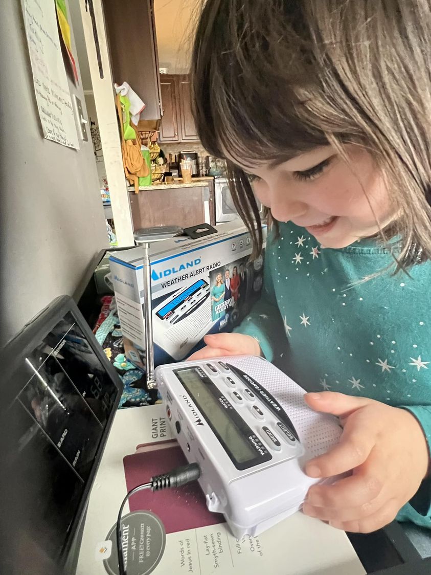
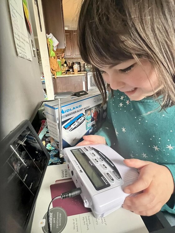
I brought home a new NOAA weather radio yesterday much to the joy of my now 6-year-old daughter, Evy, who has a legit storm phobia. Also picked up James Spann's Benny and Chipper book. After the 12/9/23 event*, we're going into the next season fully prepared, lol. *I kid you not: She was so impacted by the tornadoes that day, she told me just last week the date the last tornado in our county hit (I.e. 12/9/23). Apparently, she was listening in the backseat when I was livestreaming damage reports the following day.
-
A quick minute from SWAD 2024. James is right. More TV mets should consider being more familiar with specific landmarks and reference points when doing storm coverage.
-
If the Euro Weeklies are going warm, I'm going to expect a cold snap. I believe in Murphy's capacity to thwart and troll spring breaks in our region.
- 750 replies
-
- 3
-

-
- snow elk
- wooly worm
- (and 1 more)
-
I can appreciate this reference. Rivera's career ERA (2.21) will soon be the average snow total for most of our respective locales. P.S. It's a shame he never won a Cy Young. He deserved it in 2005.
- 750 replies
-
- 2
-
-
- snow elk
- wooly worm
- (and 1 more)
-
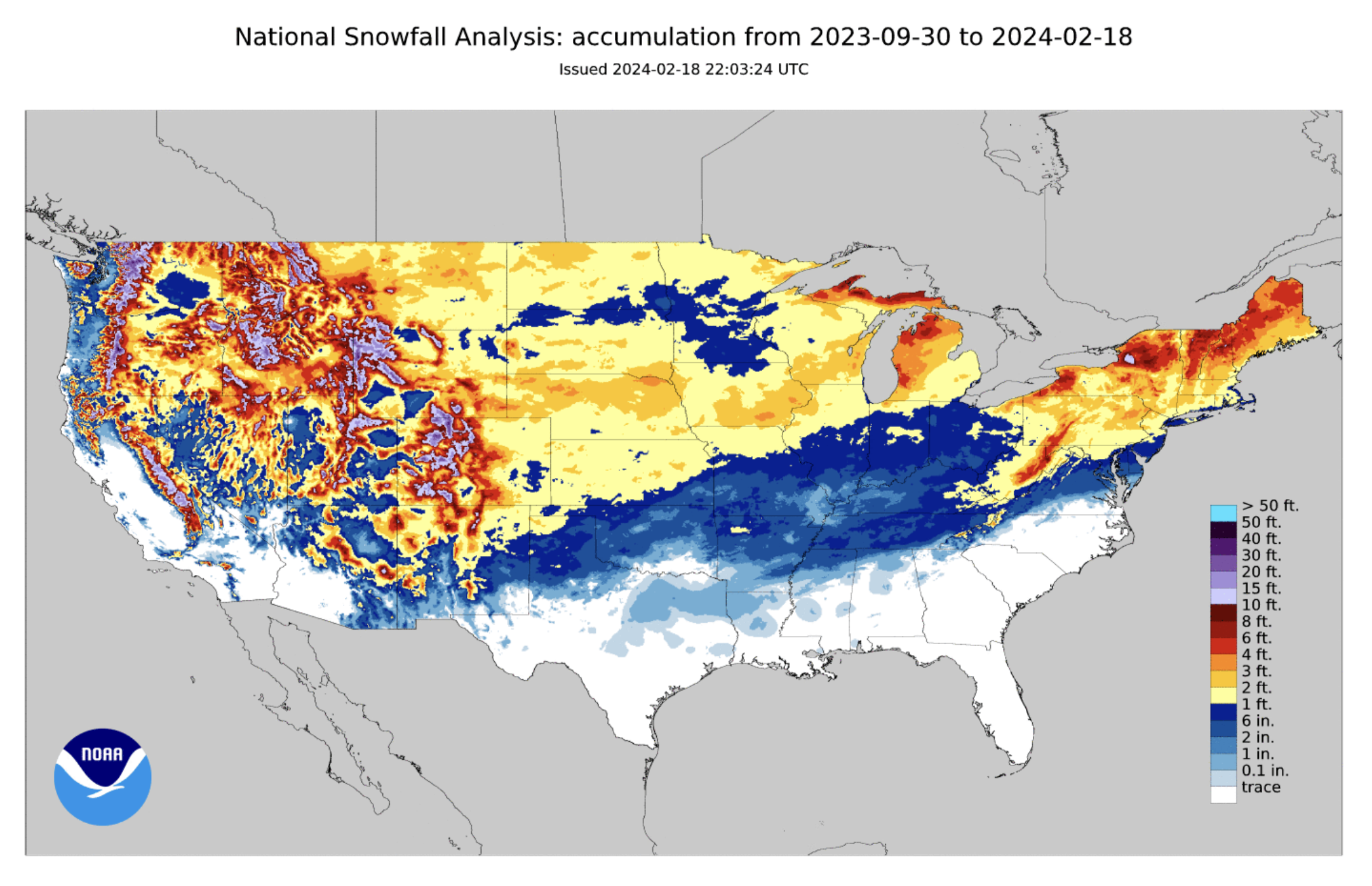
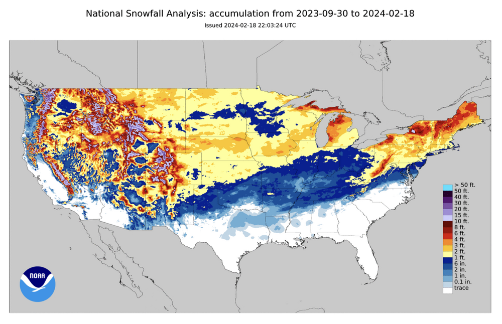
Season snowfall to date. I imagine our part of the world won't see much adjustment on the 2023-24 seasonal snowfall maps. Easily could have been worse when you consider locations to our immediate northwest and, of course, the southern mid-Atlantic down through the Carolinas. The blues in Minnesota are also telling.
- 750 replies
-
- 1
-
-
- snow elk
- wooly worm
- (and 1 more)
-
I concur with both you guys. I tend to think if a cold shot verifies, it will be too late for the valleys. Kinda in that awkward in-between phase where severe talk makes more sense for the majority but winter is still on the board for elevations partially immune to climo. While it would be great to have one more system to track, I agree with you Carver and others who have hinted at this winter clinching a passing grade depending on here you live. Had anyone told me on 12/1/23 my backyard would see 9" of snow for the winter (above average by 1981-2010 and 1991-2020 standards), I would have taken that and run. Quantity-wise, I prefer winters that produce a trackable winter storm per month on average, granted beggars can't be choosers. Sure seems to me that March is trending more towards lion than lamb. As long as the pattern doesn't become too dry and benign, I'll take it.
- 750 replies
-
- 3
-
-
- snow elk
- wooly worm
- (and 1 more)
-
A short and sweet time lapse for a short and sweet snow event during which it practically rained snow.
- 750 replies
-
- 5
-
-

-
- snow elk
- wooly worm
- (and 1 more)
-
Yeah, it was fun while it lasted. Wish I could have heard that thundersnow given it occurred on the west side of town.
- 750 replies
-
- 1
-
-
- snow elk
- wooly worm
- (and 1 more)
-
Still snowing. Almost to an inch now. Super low ratios.
- 750 replies
-
- 4
-
-
- snow elk
- wooly worm
- (and 1 more)
-
36. I don't imagine this will last long but we've secured a decent coating under some pretty strong returns. This is the wettest, slushiest snow I can remember. Instantly melts on exposed skin and funnels down fast. If you ever wanted to take a shower in snow, this is your best bet.
- 750 replies
-
- 5
-
-
- snow elk
- wooly worm
- (and 1 more)
-
Pouring snow in White Bluff. Silver dollar sized flakes. About a half inch on the ground in only 15 minutes.
- 750 replies
-
- 5
-
-
- snow elk
- wooly worm
- (and 1 more)
-
Middle TN just got NAM'd. The crazy trends continue. Gotta think there will be some northerly corrections and amounts potentially lower due to wet ratios. Timing will be key should this system speed up. Right now, it sure looks like this will be a nocturnal event.
- 750 replies
-
- 2
-
-
- snow elk
- wooly worm
- (and 1 more)
-
0z HRRR says, 'Congrats, Bowling Green. You will double your January 2024 snow total.' Smh.
- 750 replies
-
- 2
-
-

-
- snow elk
- wooly worm
- (and 1 more)
-
HRRR has me jonesin’. If it’s right, let’s freakin’ go! Like Jax, thought this was an OV special riding into church this morning. 925’s have me nervous but 850’s should do the trick.
- 750 replies
-
- 5
-
-
- snow elk
- wooly worm
- (and 1 more)
-
A few quick points in passing (Warning: My thoughts yield to west/middle TN; east TN posters can add their tweaks as needed): 1) Before I forget to say it, the transparency, humility, and corporate knowledge base on this board is why I believe it's the best of the main forum options. Discussions that compel chips towards the center of the table, that's how we all learn and grow in understanding together. A corporate job well done there. 2) I'm learning more and more how each winter setup is truly unique, a snowflake unto itself. Last decade, we saw wintry episodes that rarely featured north American teleconnection alignment between the primary players (EPO/PNA/AO/NAO). During this time, the local weather communities were adjusting to what we needed to see in our respective valleys within the context of a -PDO. The way my memory works, I recall events by themes and tropes: 2010-11 - How middle/east TN can score when the -NAO overwhelms the pattern. Second strongest Niña in the 21st century. Only 2007-08 ranks higher. 2011-12 - Pure misery on the heels of a great two-year stretch. Creds: PDO/MJO/SSWE. 2012-13 - Like the prior winter by extension but hope abounds because... 2013-14 - ...we finally see a jackpot setup for east TN. Partial creds: +TNH and PV appearances. #snowdome winter for west/middle TN. Bad history for BNA as the DJF period ranks #1 for total snow/mean temperature departure from average department. Great example of how suppression can kill chances for the western half when the Atlantic quenches the storm track. 2014-15 - My friend, the -EPO, makes a cameo and offsets the +NAO. To Carver's point, the February/March 2015 storms were mostly hits for western/middle TN with the greatest totals near the TN River. This year taught me how the Pacific can help parts of the state out, especially as the -PDO weakens. The AMO also dips briefly into negative territory. 2015-16 - Winter. Storm. Jonas. A jackpot storm for northern middle TN during a historic two-week stretch that proves to be weather loan forgiveness for 2013-14. For BNA, the 27th snowiest winter took place in the 9th warmest winter courtesy of a temporarily improved PDO. Proof of what one storm can do even when the December prior is the epitome of blowtorch. Creds: SUPER Niño (Modiki) ENSO. 2016-17 - Pretty sure everything sucked this winter. Typing the years out hurts my eyes. I'm just going to move on... 2017-18 - Dry/cold December. Slight +PNA/-EPO, again, is the solve for middle TN in mid January despite a consistent +NAO. SSWE takes place too late and gives us a cold spring. Plenty of KY snow in early March as the MJO amplification increases. Tough pills to swallow as a two-week adjustment in timing could have resulted in a top 25 snow event for many on the forum. 2018-19 - Rich man's 2016-17. PNA starts positive but quickly goes negative. +NAO fails to go negative until the spring. PDO is weak but is overrun by other teleconnections. Some nice hits northwest of TN into MO/KY/IL. Lots of MJO amplification fluctuation throughout. Second consecutive cold spring. More misery. 2019-20 - See 2016-17. This winter gets a pandemic pass. 2020-21 - The rise of the -EPO delivers a brutal late winter blow to points west of the plateau. The NAO starts negative in January but rises throughout the rest of winter. A goldmine February for the western 2/3rd's of the state that ultimately saves winter. 2021-22 - A hookup between 2015-16 and 2021-22 and another win for the -EPO/+PNA amidst a +NAO. First two weeks for middle TN see not one, not two, but three notable snow events sandwiched in just a two-week stretch. 2022-23 - A tutorial on how winter can be screwed for TN when the NAO cooperates. A true one-hit wonder and another winter to forget overall. I'll let recency bias do the talking here. 3) All of this said, we can see how last January was our mini-perfect storm the way everything came together (almost) statewide. As Carver mentioned, the award goes to the -NAO and is the testament to east TN capitalizing. Generally speaking, west/middle TN can still root for a -NAO despite greater impacts east of the plateau assuming other factors preserve a flatter flow as opposed to SW --> NE. Still, the -EPO being more of a win for west/middle TN cannot be denied despite the limited sample size above. Just my $0.02. Selah.
- 750 replies
-
- 5
-
-
-
- snow elk
- wooly worm
- (and 1 more)
-
I was thinking the same thing, Matthew. The consolation prize to #wintercancel (being facetious there), is the split flow pattern helping keep us wet. When the year started, I recall some having concerns we wouldn’t bust the drought heading into spring. I look forward to the next Drought Monitor on Thursday to see how far we’ve come in recent weeks.
- 750 replies
-
- 2
-
-
- snow elk
- wooly worm
- (and 1 more)
-
If we lose the EPO and it flips +, I say it’s under 50/50 though it depends on where you live. Not sure if winter can return if the MJO and EPO aren’t in our corner. We’re asking a whole lot from the Atlantic side at that point. ssstwitter.com_1707587255443.mp4
-
Yeah, the GFS hasn’t been trending well this week. Hopefully, there is some error involved as Carver pointed out.