*Flash*
-
Posts
925 -
Joined
-
Last visited
Content Type
Profiles
Blogs
Forums
American Weather
Media Demo
Store
Gallery
Everything posted by *Flash*
-
I know it’s been shared before but can you remind some of us where we can find these verification scores? I think it would be a fascinating study to analyze model scores by the six ENSO patterns.
- 750 replies
-
- 1
-

-
- snow elk
- wooly worm
- (and 1 more)
-
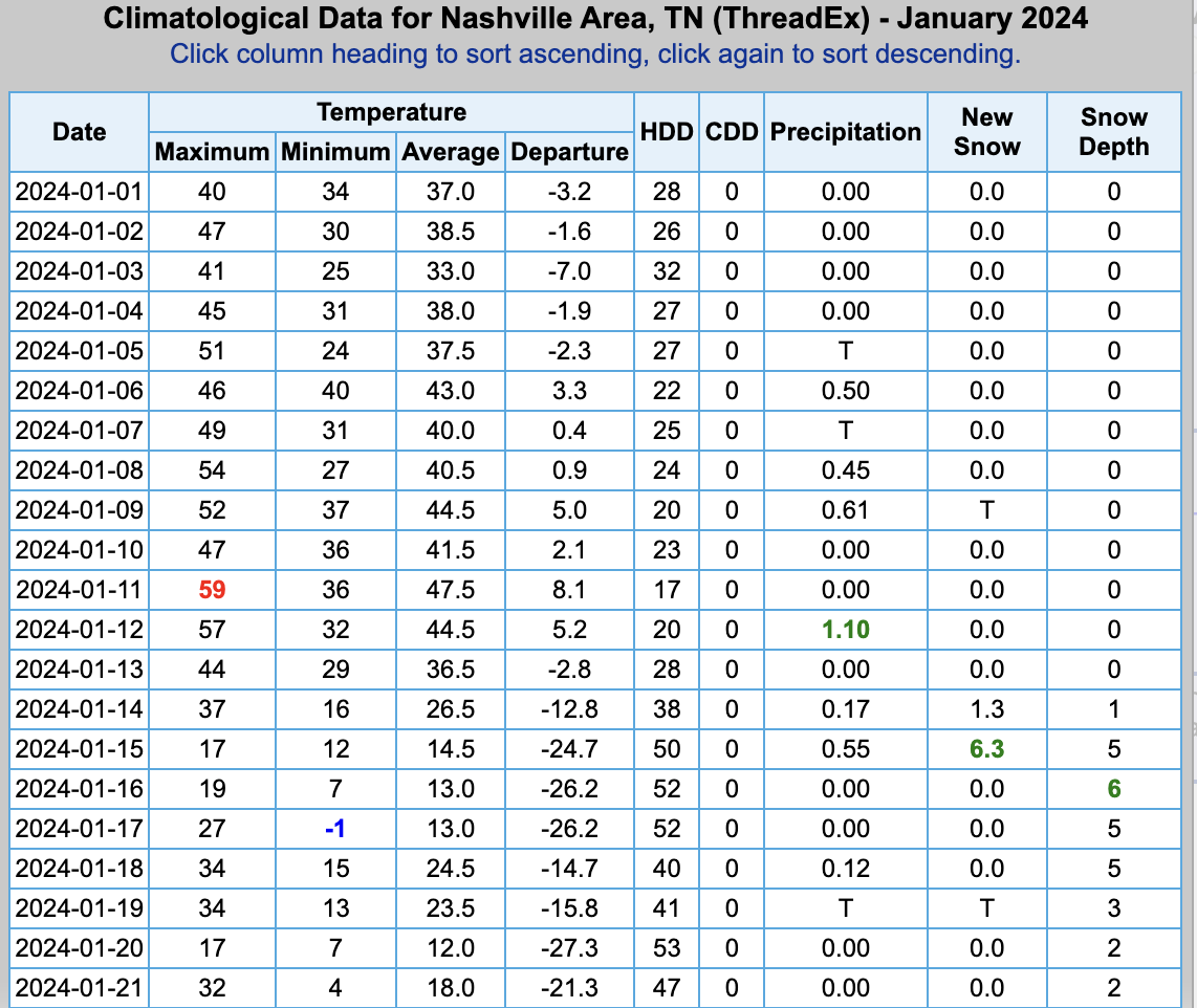
Officially lost the finishing touches to what was our coldest week since 1994 (30 years) and the longest snow duration (1+") in 46 years. Why not conclude matters with another timelapse! a
-
Update to my post above: If BNA maintains another 1+” day by midnight, you would have to go all the way back to January 13-29, 1978 to find a longer duration. Clearly, Winter Storm Heather is one for the record books!
-
Going through past BNA CF6's today. Unless I'm missing something, I believe this is the longest stretch of measurable snow (1"+) on the ground in almost 40 years! January 1988 and February 1996 came close but both occurrences didn't last a full week at least at the airport.
-

January Medium-Long Range Discussion
*Flash* replied to Holston_River_Rambler's topic in Tennessee Valley
Man, that is one happy pattern! -
January Medium-Long Range Discussion
*Flash* replied to Holston_River_Rambler's topic in Tennessee Valley
For the first time in my life, I started singing, '♫ Here comes the sun ♫'...when it was single digits outside. A fitting tribut to January 2024 once all is said and done. -
January Medium-Long Range Discussion
*Flash* replied to Holston_River_Rambler's topic in Tennessee Valley
Another winter, another fascinating teleconnection tug-of-war! From what I'm hearing and seeing, we got a decent PAC again but decreasing favor with the MJO/NAO/ENSO. I think thaw week will bring some critical clarity. Like many, I agree with Carver and others who are shining the light on February's second half. Personally, I'm tempted to throw climo out the window given a) expectations have generally been 1-2 weeks delayed since met winter started and b) the pattern has been slightly more fluid than progressive. With so many question marks surrounding the 'decreasing favor' elements mentioned above, I'm tempted to yield to the most consistent signals. Netting it all out for our part of the world, not seeing evidence of long-term PAC troughing and SER expands the tent pegs of our playing field enough for me to believe strong blocking will be back. The questions to me boil down to the magnitude of stratospheric warming/timing, if a strong -EPO/+PNA can offset wherever the MJO eventually fades into, and can we preserve moisture supply the next time cold air invades. Regardless, it will be interestoing to see where the next arctic amplification axis sets up after our 2-3 week warm-up. TN was in the perfect spot this last go-around as noted by many of our metros being some of the coldest spots in the entire conus a few morning ago. P.S. For all your guys in NC, I'm starting to feel guilty. If it's any consolation, I wouldn't mind you guys getting the next banger to end your misery. -
Bonus snow showers swinging through northern middle TN this morning. Any exposed surfaces are getting an extra layer of dippin' dots. 8:15 am CT Update: DBZ's have really picked up the last few frames so I wonder if there's any 'lake effect' resulting from Kentucky Lake/Lake Barkley?
-
OHX just issued a WWA for most of the midstate. Bizarre looking advisory area based on the probabilities. Like Bearman mentioned, hate that most of this may be FZRA. While surface temps may verify on the under, I don't see thermals a couple thousand feet up cooperating. What a mess! Hopefully, trends will be wetter or snowier.
- 372 replies
-
- 3
-
-
- cold
- arctic blast
- (and 1 more)
-
January 15th-17th 2024 Arctic Blast/Snow Event
*Flash* replied to John1122's topic in Tennessee Valley
-
January 15th-17th 2024 Arctic Blast/Snow Event
*Flash* replied to John1122's topic in Tennessee Valley
Yeah, this is up there for me along with 2/4/96, 1/16/03, and 1/22/16. Definitely a top 3-4 snow in 30 years living in TN. We had great winter storms in 1994, 2008, 2010-11, and February 2015/2021...but many of them had ice cut into totals. In terms of pure snow, this is up there with the greatest hits. -
January 15th-17th 2024 Arctic Blast/Snow Event
*Flash* replied to John1122's topic in Tennessee Valley
Up to 7" of snow in the Bluff as of 1:30 pm CT. -
January 15th-17th 2024 Arctic Blast/Snow Event
*Flash* replied to John1122's topic in Tennessee Valley
So, I know the event is still ongoing...and I need to get caught up on about 15 pages of comments. In terms of modeling W's and L's, how are we breaking down performance? Certainly, NOT a win for the Euro at least for my area... -
January 15th-17th 2024 Arctic Blast/Snow Event
*Flash* replied to John1122's topic in Tennessee Valley
Good morning! I woke up at 6:15 pm CT to 4.1" in White Bluff. We're now at 5.5-6". MUCH more than I expected... -
January 15th-17th 2024 Arctic Blast/Snow Event
*Flash* replied to John1122's topic in Tennessee Valley
Judging by the reflectivity and what's fallen so far, should be at an inch within the next 30. Ratios doing there thing here. -
January 15th-17th 2024 Arctic Blast/Snow Event
*Flash* replied to John1122's topic in Tennessee Valley
Snow officially underway in White Bluff. A few tenths of an inch already! -
January 15th-17th 2024 Arctic Blast/Snow Event
*Flash* replied to John1122's topic in Tennessee Valley
CMC and HRRR with slight NW trends. For Nashville metro, you take the 15z HRRR over 12z 10/10. Hopefully, the extent of the NW precip shield expands to include more of the populace. Still worried about dry air north of 40/west of 65. Regardless, that 700 jet will be howling over my location. -
January 15th-17th 2024 Arctic Blast/Snow Event
*Flash* replied to John1122's topic in Tennessee Valley
Updated call from my guy, Bobby Boyd. This looks about right. @jaxjagman, I'll be riding this out about 4-5 miles SE of Brentwood. -
January 15th-17th 2024 Arctic Blast/Snow Event
*Flash* replied to John1122's topic in Tennessee Valley
You're welcome! -
January 15th-17th 2024 Arctic Blast/Snow Event
*Flash* replied to John1122's topic in Tennessee Valley
I so want to buy this... -
January 15th-17th 2024 Arctic Blast/Snow Event
*Flash* replied to John1122's topic in Tennessee Valley
Theme of the day: It depends, haha. One thing I can appreciate with these threats: For west/middle TN, the microclimatology is relatively less complex compared to east TN. Plenty of secondhand learning with many on here on or east of the plateau. That’s a silver lining when these threads emerge. P.S. The ICON from earlier was only mentioned in passing for having the most coast to coast purple. In Union City traveling today and my car is already white from the salt, lol. -
January 15th-17th 2024 Arctic Blast/Snow Event
*Flash* replied to John1122's topic in Tennessee Valley
I just want to cash out on the 18z Icon. Too good to be true, I know. -
January 15th-17th 2024 Arctic Blast/Snow Event
*Flash* replied to John1122's topic in Tennessee Valley
The battle continues. Not sure I’ve ever seen such a contrast between the global models and the hi resolution models. I already feel like the forum has laid the premise for what will be a fascinating case study when all is said and done. -
January 15th-17th 2024 Arctic Blast/Snow Event
*Flash* replied to John1122's topic in Tennessee Valley
18z HRRR looks decent for west/middle TN. A sigh of relief for now. I imagine this is the time we should start focusing more on short term resolution guidance. -
January 15th-17th 2024 Arctic Blast/Snow Event
*Flash* replied to John1122's topic in Tennessee Valley
I’m just terrified of the prospect of having brutal cold with no snow to show for it. May have to chase with the kiddos on this one.