*Flash*
-
Posts
925 -
Joined
-
Last visited
Content Type
Profiles
Blogs
Forums
American Weather
Media Demo
Store
Gallery
Everything posted by *Flash*
-

Summer-Fall 2024 Weather Disco Med/Long Range
*Flash* replied to John1122's topic in Tennessee Valley
I'm wondering if there should be a separate tropical thread? Either way, it's been a fascinating weather day. I didn't think when it started we would be talking about Milton threatening Wilma's lowest Atlantic pressure mark (882 mb), but here we are wondering if this thing will flirt with 200 mph peak winds before dry air starts to fix in. Certainly, the explosive tightening of the core has been textbook material. Curious if this will have room to weaken down to CAT-3 before landfall if the intensity ceiling keeps climbing...?- 688 replies
-
- 2
-

-
- heat
- thunderstorms
- (and 7 more)
-
Summer-Fall 2024 Weather Disco Med/Long Range
*Flash* replied to John1122's topic in Tennessee Valley
I see 40's for lows on the horizon! May be a mirage for my area but I'll take the visual, even on the crap apps. Either way, the pattern seems transient with the northwestly flow taking more of the controls. Fall is definiteiy a dish best served cold-er.- 688 replies
-
- 1
-
-
- heat
- thunderstorms
- (and 7 more)
-
Summer-Fall 2024 Weather Disco Med/Long Range
*Flash* replied to John1122's topic in Tennessee Valley
100% agree. It will take some time but also be well worth it in hindsight.- 688 replies
-
- 1
-
-
- heat
- thunderstorms
- (and 7 more)
-
Summer-Fall 2024 Weather Disco Med/Long Range
*Flash* replied to John1122's topic in Tennessee Valley
Harvey begs for a redo on this graphic.- 688 replies
-
- 1
-
-
- heat
- thunderstorms
- (and 7 more)
-
Summer-Fall 2024 Weather Disco Med/Long Range
*Flash* replied to John1122's topic in Tennessee Valley
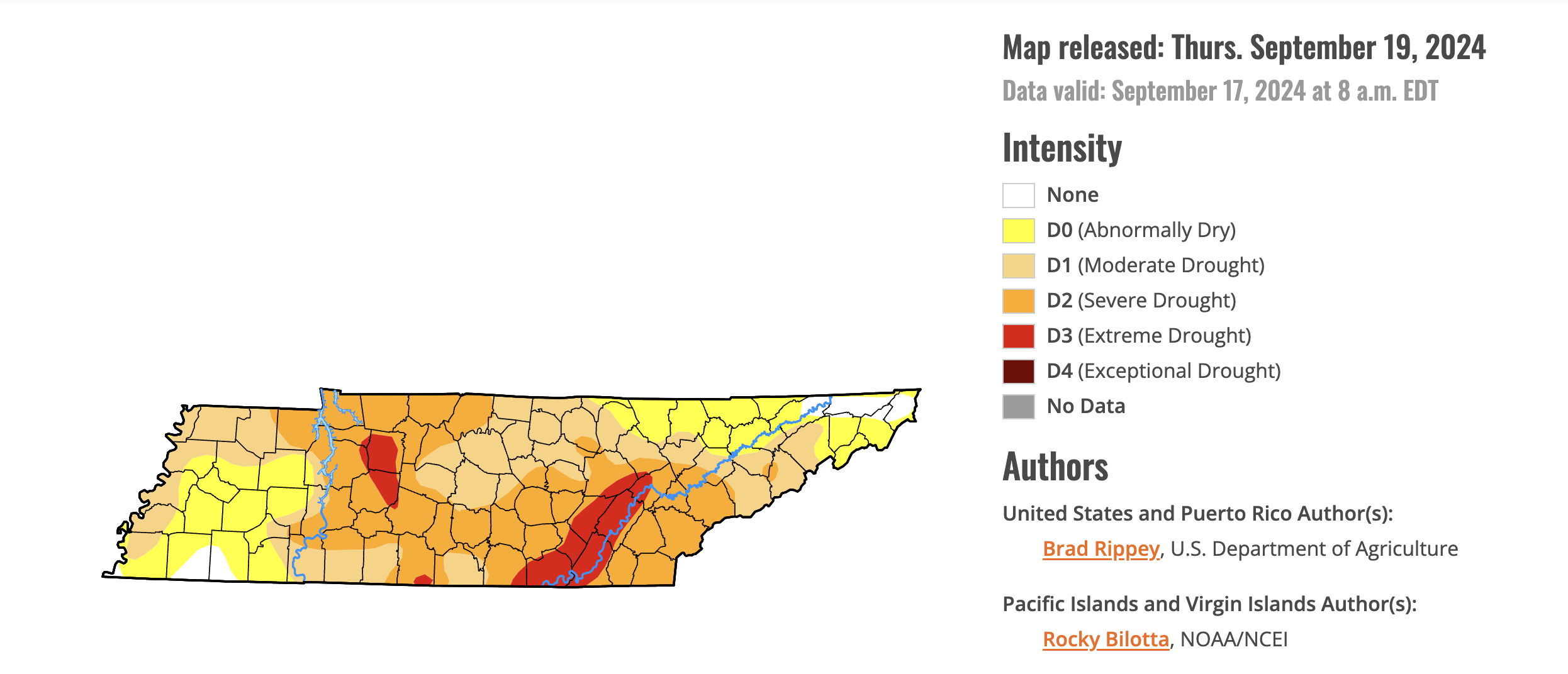
Last Thursday's USDM Outlook. Many locales still needing a lot of rain to bust the drought, especially east of the TN River's western extent. I'm knocking on the door of D3 IMBY as Francine didn't move the needle in our area.
- 688 replies
-
- 3
-

-
- heat
- thunderstorms
- (and 7 more)
-
Summer-Fall 2024 Weather Disco Med/Long Range
*Flash* replied to John1122's topic in Tennessee Valley
Watch 6:15-7:13. We could be seeing a Fujiwhara effect taking shape over our state in a few days.- 688 replies
-
- 7
-

-
-
- heat
- thunderstorms
- (and 7 more)
-
Summer-Fall 2024 Weather Disco Med/Long Range
*Flash* replied to John1122's topic in Tennessee Valley
Yep. It doesn't look like west TN is under the gun right now. Seems like the Euro Ensemble mean is moving the next tropical disturbance eastward though that could change by this time tomorrow. Whatever the case, it shouldn't have any issue moving north by north____ with that ridge displaced over the eastern midwest/Great Lakes as part of that pre-existing Omega block pattern. Granted, I note that potential low moving into those regions next week which could affect UL steering winds. -
Summer-Fall 2024 Weather Disco Med/Long Range
*Flash* replied to John1122's topic in Tennessee Valley
Nice touch, NWS-Memphis. Way to take advantage of the opportunity…- 688 replies
-
- 4
-
-

-
- heat
- thunderstorms
- (and 7 more)
-
Summer-Fall 2024 Weather Disco Med/Long Range
*Flash* replied to John1122's topic in Tennessee Valley
Sure doesn't look like fall is in the 7-10 Day Outlook for west/middle TN...- 688 replies
-
- 4
-
-
-
- heat
- thunderstorms
- (and 7 more)
-
Summer-Fall 2024 Weather Disco Med/Long Range
*Flash* replied to John1122's topic in Tennessee Valley
I'm setting the over/under 1.5 crap emojis vs. 1.0 weenie emojis as the primary ratio during the November 15-March 15 time period.- 688 replies
-
- 2
-
-
- heat
- thunderstorms
- (and 7 more)
-
Summer-Fall 2024 Weather Disco Med/Long Range
*Flash* replied to John1122's topic in Tennessee Valley
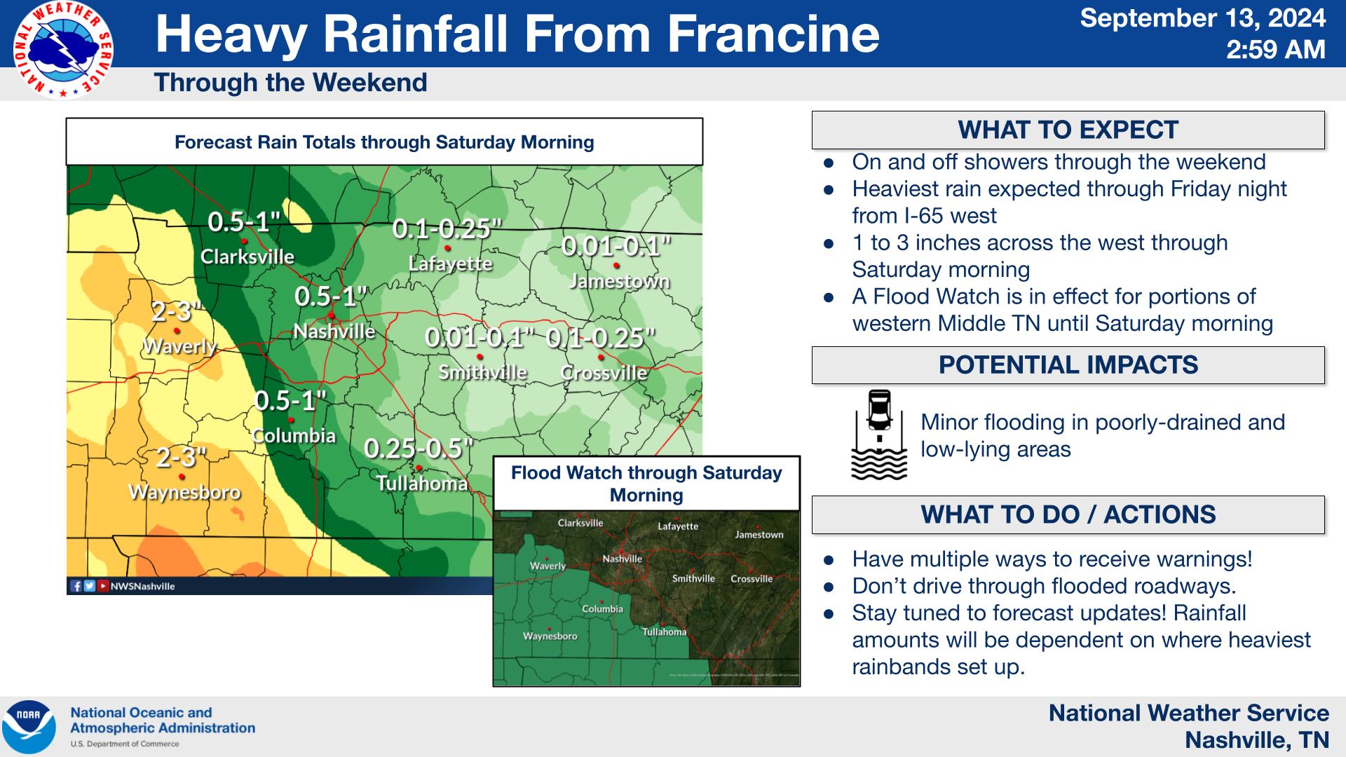
I 'escaped' Francine with just a hair over 2". Just 10-15 miles down 70, you were hard-pressed to find anything over .75". The sharp gradient on the east side was definitely a middle finger to 65 locales.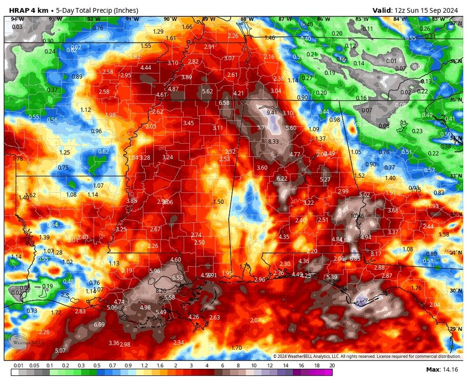
- 688 replies
-
- 2
-
-
- heat
- thunderstorms
- (and 7 more)
-
Summer-Fall 2024 Weather Disco Med/Long Range
*Flash* replied to John1122's topic in Tennessee Valley
Disappointment aside, the mid-state still has to keep her guard up later today.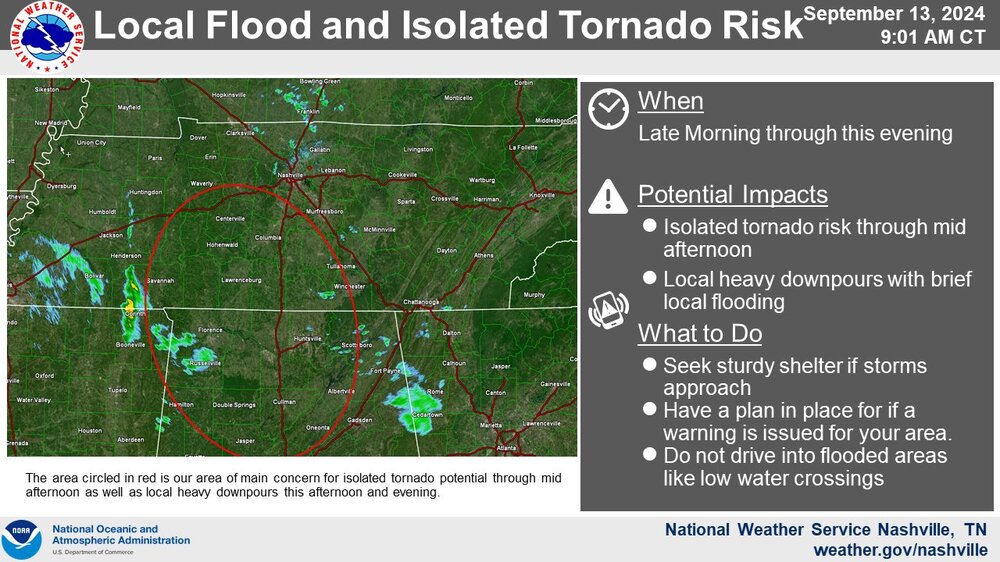
- 688 replies
-
- 2
-
-
- heat
- thunderstorms
- (and 7 more)
-
Summer-Fall 2024 Weather Disco Med/Long Range
*Flash* replied to John1122's topic in Tennessee Valley
Social media has been torching the NWS since this graphic released earlier this morning. Not a good day to be a local met around these parts. As a math guy, I get model deviation potential but this 50 mile shift was brutal for those expecting rain who really needed it.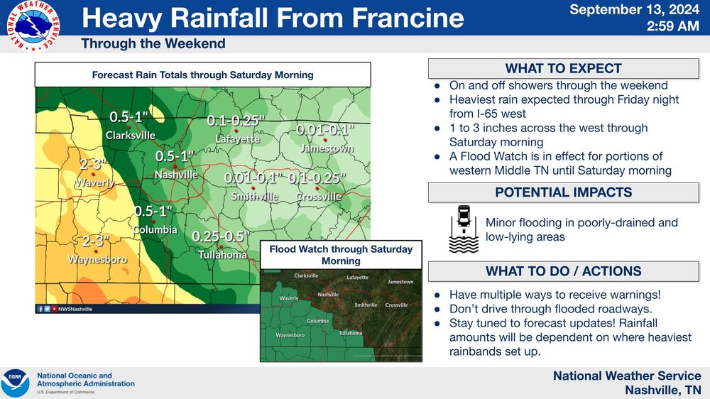
- 688 replies
-
- 2
-
-
-
- heat
- thunderstorms
- (and 7 more)
-
Summer-Fall 2024 Weather Disco Med/Long Range
*Flash* replied to John1122's topic in Tennessee Valley
This is the type of salty the world needs. The faint dream of flakes flying on Halloween. Hey, my first 10/31 in Tennessee as a little kid, it happened!- 688 replies
-
- 2
-
-
- heat
- thunderstorms
- (and 7 more)
-
Summer-Fall 2024 Weather Disco Med/Long Range
*Flash* replied to John1122's topic in Tennessee Valley
For sure! I'm glad drought-stricken areas south and west of Nash will get the brunt of the Francine's rain. I'm hopeful any areas of moderate/extreme drought will vanish by time next week's drought monitor report comes in.- 688 replies
-
- 1
-
-
- heat
- thunderstorms
- (and 7 more)
-
Summer-Fall 2024 Weather Disco Med/Long Range
*Flash* replied to John1122's topic in Tennessee Valley
Many people in my area are mowing their lawns on a B+ evening by early August standards. But for me? I'm waiting until Saturday to do my yard work as even cooler temps/lower dewpoints will prevail. Mother Nature will soon be on her 'A' game with respect to dog day weather and its timing. Net-wise, we've had a solid stretch since July 15 minus a few scattered sorchers.- 688 replies
-
- 5
-
-
- heat
- thunderstorms
- (and 7 more)
-
Summer-Fall 2024 Weather Disco Med/Long Range
*Flash* replied to John1122's topic in Tennessee Valley
I want to say that summer started hot, went cool, and then ended hot before settling into a pattern that would preview the epic winter to come. While I don't want to get lost in a 1995-96 analog, I will say what we're experiencing now has been refreshing in every sense of the word. 6-8 weeks ago, the way local conjecture sounded, I was concerned we would torch during these dog days. Instead for most of middle TN outside an UHI...we may not taste 90 the rest of the month. A remarkable stretch purely on timing alone. It currently feels more like 4/23 or 10/23 outside. Plenty of summer left but right now, it's look like a passing grade will verify.- 688 replies
-
- 1
-
-
- heat
- thunderstorms
- (and 7 more)
-
Summer-Fall 2024 Weather Disco Med/Long Range
*Flash* replied to John1122's topic in Tennessee Valley
Got a quick inch in under an hour earlier this afternoon. Lots of pondy roads and runoffs. Stay safe driving out if you find yourself under one of these parked cells. Slow movers today.- 688 replies
-
- 1
-
-
- heat
- thunderstorms
- (and 7 more)
-
Summer-Fall 2024 Weather Disco Med/Long Range
*Flash* replied to John1122's topic in Tennessee Valley
That December was brutal statewide but Jonas made up for it (at least locally) the next month when our two-week window finally opened. I remember doing some digging on this winter 8 years ago. BNA had the 27th snowiest winter during the 9th warmest winter in recorded history. Speaks to the fact that it only takes one hit to make a winter. Last year was reminiscent to this in several ways. Also, let's hope the mild early winter potential doesn't produce another severe weather episode. Forget the anomalies, that's my greatest concern.- 688 replies
-
- 2
-
-
- heat
- thunderstorms
- (and 7 more)
-
Right now, SPC has a Marginal Risk for west/middle TN. As BB tweeted earlier, if we can get some instability tomorrow, the kinematics are there; however, l could see this threat going the other way and "busting" altogether. We shall see.
-
Yep. I don't know what it is about this part of Kentucky as it has seen its share of long-track, violent tornadoes in recent years.
-
Crazy to watch what's going on in west/central KY tonight. Definitely an outbreak on our hands though it seems down in TN, we'll have more CIN/weaker lift to mitigate the threat.
-
A short time lapse of the Columbia tornado I intercepted earlier today. I positioned myself a few miles south of the track...
-
January 15th-17th 2024 Arctic Blast/Snow Event
*Flash* replied to John1122's topic in Tennessee Valley
For posterity... -
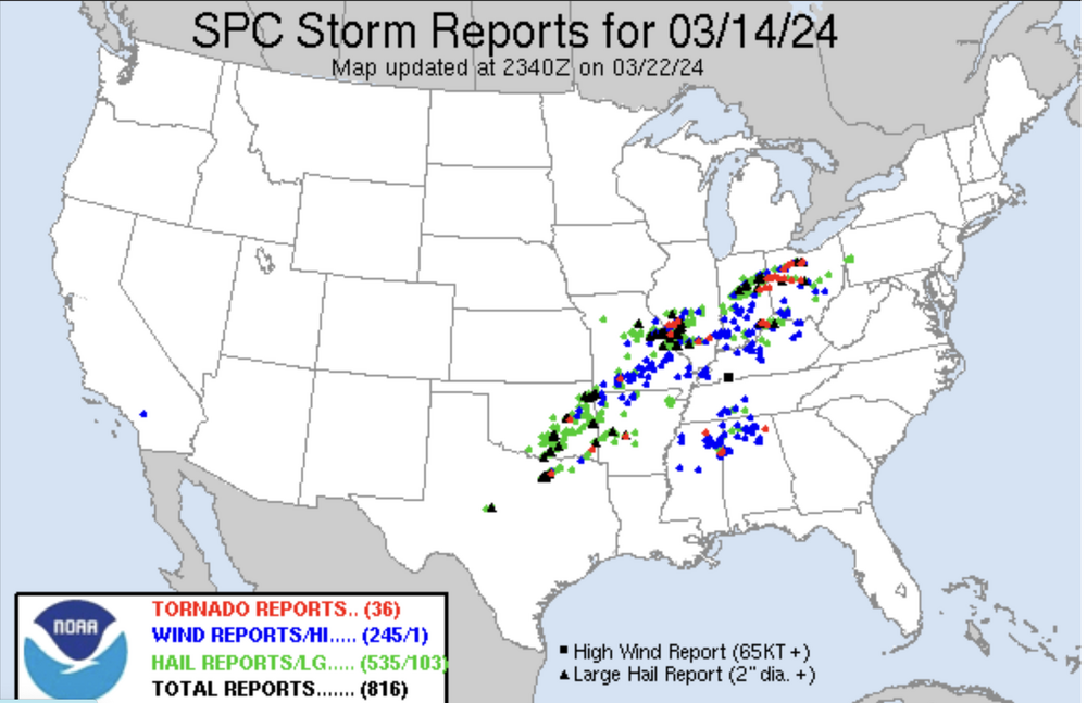
SPC states the predictability is too low at this point. We shall see what happens. On a separate note, if you would have asked me one month ago March would finish 4-5° above normal with only a handful of statewide reports (3/14/24 was our only semi-active day), I would have cited nonsense. A remarkably quiet month!