

high risk
-
Posts
3,107 -
Joined
-
Last visited
Content Type
Profiles
Blogs
Forums
American Weather
Media Demo
Store
Gallery
Everything posted by high risk
-
1.43" for the day. Solid!
-

2022 Mid-Atlantic Severe Wx Thread (General Discussion Etc)
high risk replied to Kmlwx's topic in Mid Atlantic
Deep-layer shear in our area is really crap (way better to the north), but given that storms will likely be organized and that the soundings have some appreciable downdraft CAPE, I guess I can get on board with the idea of a watch being issued. -
2022 Mid-Atlantic Severe Wx Thread (General Discussion Etc)
high risk replied to Kmlwx's topic in Mid Atlantic
Totally get where you're coming from on this, but I'll throw out 2 counterpoints: 1) For today, remember that SPC has to have boundaries on their watches *somewhere*, and if you're in one of those "last counties", unless you've got an adjacent watch box on the other side of the box, your threat is pretty low. They typically make the watches slightly bigger than needed to allow for some margin for error. The chances of SVR today extending all the way south to Howard were always pretty low. 2) Monday was frustrating, but the big hail-producing cell that crushed the southern DC burbs shows that high-end potential did exist. The failure was overpredicting the coverage, which happened after the poorly-modeled midday convection screwed up the environment for a lot of us. -
2022 Mid-Atlantic Severe Wx Thread (General Discussion Etc)
high risk replied to Kmlwx's topic in Mid Atlantic
for sure, but the show may still be well north of there too. -
2022 Mid-Atlantic Severe Wx Thread (General Discussion Etc)
high risk replied to Kmlwx's topic in Mid Atlantic
As noted, that MCV is going to be a big player today, but it looks like most of the activity will be in PA. I wouldn't be surprised, based on the latest HRRR runs, if they go ENH there. Looks like less of a chance for the DC/Baltimore areas, but these MCVs can be tricky to model. -
2022 Mid-Atlantic Severe Wx Thread (General Discussion Etc)
high risk replied to Kmlwx's topic in Mid Atlantic
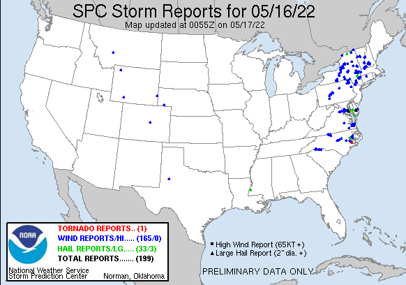
So, um, that 45 wind area from the morning outlook didn't work out very well.....
-
2022 Mid-Atlantic Severe Wx Thread (General Discussion Etc)
high risk replied to Kmlwx's topic in Mid Atlantic
Storms are starting to intensify as they move east of I-81, and they're about to move into an environment with moderate CAPE values and 50 kt of deep layer shear. It likely won't be a higher-end or widespread SVR event, but there will definitely be severe reports in northern VA and central and eastern MD later this afternoon. -
2022 Mid-Atlantic Severe Wx Thread (General Discussion Etc)
high risk replied to Kmlwx's topic in Mid Atlantic
That's a very reasonable take. I will note that the longer we have to wait for any threat to materialize, the better the shear gets. -
2022 Mid-Atlantic Severe Wx Thread (General Discussion Etc)
high risk replied to Kmlwx's topic in Mid Atlantic
Oh, I'm with you all the way. I'm curious how they reached the decision. -
2022 Mid-Atlantic Severe Wx Thread (General Discussion Etc)
high risk replied to Kmlwx's topic in Mid Atlantic
Those TOR and WIND probs were definitely set too high. But I agree with you that we shouldn't completely swing the pendulum all the way to the other side and go total 'meh' - there is still some SVR threat, especially for those along and east of I-95. -
2022 Mid-Atlantic Severe Wx Thread (General Discussion Etc)
high risk replied to Kmlwx's topic in Mid Atlantic
CAMs are all over the place for this afternoon, and none of them really have a good handle on this lead convection. The HRRR is now at least starting to initialize the ongoing storms, and it still ramps up a line right along the I-95 corridor during the mid-late afternoon hours. But the ongoing storms are stronger and in greater coverage than the HRRR has, so I'm still not convinced that it will capture the evolution. I'm actually rooting for SVR, given that Howard County is releasing schools early. I would hate for their decision to be ridiculed, leading them to not dismiss early on a future day where it was really needed. -
2022 Mid-Atlantic Severe Wx Thread (General Discussion Etc)
high risk replied to Kmlwx's topic in Mid Atlantic
If you're looking for significant supercell potential, prepare to be very disappointed. I know that SPC has us in the 5 TOR, but I've always thought of tomorrow as a wind day. There is deep layer shear to support SVR, but the low-level shear to ramp up the TOR potential is pretty marginal at best. That's especially true if it ends up as an early show. The NAM Nest has gone back to a single beefy squall line later in the day, but other CAMs seem to prefer an earlier, broken line. Among those, there is disagreement as to whether a second line will roll through later in the day; a second line might have better wind fields to work with. I still line the overall wind threat tomorrow, although unless the 00Z NAM Nest idea is right, it's probably more of a SLGT than an ENH. -
2022 Mid-Atlantic Severe Wx Thread (General Discussion Etc)
high risk replied to Kmlwx's topic in Mid Atlantic
Agreed. NAM Nest for Monday afternoon looks impressive, both in terms of forecast soundings and simulated reflectivity. -
2022 Mid-Atlantic Severe Wx Thread (General Discussion Etc)
high risk replied to Kmlwx's topic in Mid Atlantic
Sorry, @yoda. Didn't see your question earlier, but this explanation is correct. You typically get stronger flow around the edges of a ridge, and there is a typically a "quality" air mass in place beneath. Add a few disturbances moving through that faster flow, and you're in business. -
2022 Mid-Atlantic Severe Wx Thread (General Discussion Etc)
high risk replied to Kmlwx's topic in Mid Atlantic
I keep waiting for a "real" severe threat to develop here, and by that I mean something with a legitimate amount of instability, and not those cool season low CAPE - high shear events. Climo generally says that we have to wait until mid May or so, and right on schedule, it looks like Monday may have some modest potential. -
I think I should have said "this afternoon and evening". Radar shows very much a rapidly increasingly convective nature to the precipitation across our area.
-
Seems like there is a good chance of embedded thunder during the evening hours. While it's a bit uncertain how far north the warm front will get, I agree with SPC that any cells in the warm sector or especially ones that interact with the boundary have potential to spin. For DC and points north (and probably even a bit further south than that, as I have doubts how far north the warm front will make it before retreating), any storms will be elevated, eliminating the severe potential but allowing for some hopefully nice lightning and thunder.
-
Two days of wet and upper 40s during a May weekend is as ugly as it gets.
-
I think so. NAM Nest has been adamant that we'll stay in the mid to upper 50s, at least on the northeast side of town. HRRR seems to be coming around to the same idea.
-
I can confirm that there were pingers here a few miles south of you this morning.
-
And now a few small hailstones.
-
Thunder in Howard County.
-
2022 Mid-Atlantic Severe Wx Thread (General Discussion Etc)
high risk replied to Kmlwx's topic in Mid Atlantic
good call! -
2022 Mid-Atlantic Severe Wx Thread (General Discussion Etc)
high risk replied to Kmlwx's topic in Mid Atlantic
Agreed. Ultimately, I think it's going to come down to the surface dew points. The NAM Nest and ARW2 keep dew points around 60 ahead of the line, and both have impressive reflectivity signatures. Other CAMs (including the HRRR) mix out the low-level moisture and end up with mid 50s dew points, and their simulated radars look very meh. -
2022 Mid-Atlantic Severe Wx Thread (General Discussion Etc)
high risk replied to Kmlwx's topic in Mid Atlantic
Really not sure what to make of the SVR chances this afternoon. Pretty much every CAM brings some sort of line or broken line through the area (with perhaps a few stronger cells immediately behind), but there is no agreement on intensity. Overall, based on simulated reflectivity, it's tough to expect more than a few SVR reports, but if we can maximize surface heating without mixing out the low-level moisture, perhaps we can have a modestly more interesting event.


