high risk
-
Posts
3,150 -
Joined
-
Last visited
Content Type
Profiles
Blogs
Forums
American Weather
Media Demo
Store
Gallery
Everything posted by high risk
-
I will admit that I don't trust it, but there was a pretty clear signal in the 12Z CAMs for heavy rain to break out on the east side of DC and over to the Eastern Shore during the mid evening hours.
-
Yeah, the CAMs this evening look more like the earlier globals with decent rains from the Bay to all points west. Still not as good of a consistent signal for the Eastern Shore, but it does seem like even those areas should eventually do at least ok (later Tuesday into Wednesday??).
-
Fri/Sat is definitely worth watching, but there is a lot of disagreement on whether we get decent height falls or if they're focused more north of here. Any modest height falls would probably bring a severe threat, given the good moisture in place and good wind fields.
- 1,378 replies
-
- 4
-

-
- severe
- thunderstorms
- (and 2 more)
-
People on the east side of the Potomac are going to truly hate the morning hi-res runs.
-
Notable speed-up in the overnight and morning guidance with the arrival of the rain: initial shower bands may arrive before the dinner hour on Monday.
-
Still a pretty good signal in the evening CAMs for at least scattered convection Tuesday afternoon for those mainly north of the DC Beltway
-
The problem is that the upper low now looks to cut off further west, so Sunday is probably now a warm day with convection that the GFS is likely not resolving well. That said, it could very well end as an event with winners and losers instead of everyone getting some love.
-
Really nice supercell in western Maryland this afternoon.
- 1,378 replies
-
- 5
-
-
- severe
- thunderstorms
- (and 2 more)
-
Looking great for a big soaking later in the weekend into at least early next week. Note that there is a separate thread for this event.
-
There is a bit of a signal for the highest amounts being north of here, but all 3 global ensemble means are 2"+ for most of this subforum, and 2 out of 3 have 2+" for the entire subforum. And it's spread out over multiple days instead of being some convective deluge that can't sink in. This looks a much-needed huge win for our region.
-
Full-blown, massive cave.
-
In particular, the GEFS made a huge move towards the other guidance.
-
Latest HRRR initializes it well and does try to bring it into Montgomery/Loudoun before weakening. It actually shows lapse rates increasing a bit, generating some elevated CAPE, so perhaps it *could* hold together further east than initially thought.
-
I'm calling it a night before waiting for the 00Z suite, but it's worth noting today that the Euro and AI-Euro both have the weekend trough cutting off and hanging around for a while and giving us a much-needed multi-day rain event. It seems to have some ensemble support. The GFS/GEFS, prior to the overnight runs, are very progressive with the trough and want nothing to do with the Euro idea.
-
The slightly slower solution ended up verifying, and we do have a MRGL along and east of I-95 for this afternoon. There is actually some good model agreement that a broken line of thunderstorms will form around 2pm very close to I-95 in Maryland and extend at least a bit south of DC on the Virginia side. Looks like there will be some instability, but deep layer shear looks slightly weaker than it did in earlier progs, so a MRGL seems to be the right call (but a few wind reports are certainly possible, especially further east).
- 1,378 replies
-
- 4
-
-
- severe
- thunderstorms
- (and 2 more)
-
Yeah, widespread heavy convection Friday night (as depicted on that one NAM Nest run) just doesn't seem likely, although there could be a few good downpours for some lucky areas. After that, I'm glad to see some ensemble agreement for a strong trough passage the following weekend, but I don't like seeing the prolonged signal for northwest flow after that.
-
If the NAM Nest and HiResW ARW2 are correct, there would be a MRGL and eventually perhaps a SLGT for Saturday along and east of I-95, but they seem to be outliers with their slower timing and higher dew points (driving good instability with modest deep layer shear). Since slow timing and overmoistening are clear biases of both systems, it's unfortunately tough to buy their solution. At this point, I just hope to cash in on some heavier showers Friday evening and overnight.
-
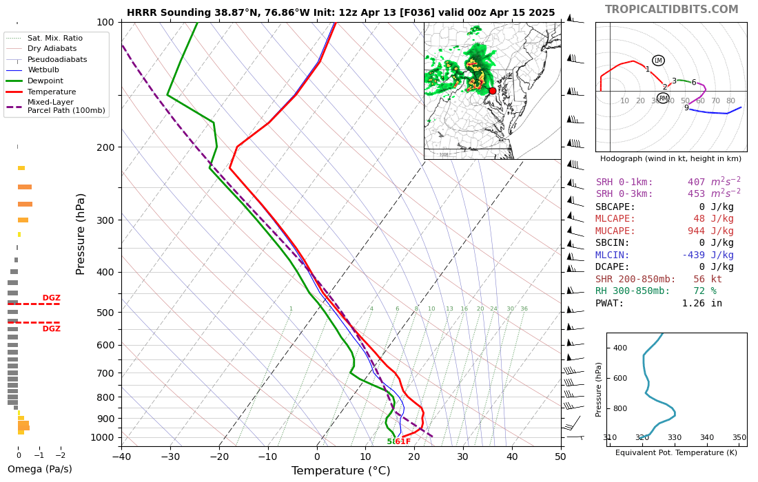
The EML will definitely be there, but the impact of an EML can be significantly lessened if you're dealing with a stable surface layer. You're all spot on that every hour earlier that convection arrives makes a huge difference here. Let's look at the HRRR temperatures, since it's the warmest model. Here is peak heating time: That's plenty warm for the Shenandoah Valley and across most of northern VA, but it's much cooler across central MD, and other guidance seems to be in agreement. Not sure that earlier arrival will help as much for areas east of the Potomac as we think. The HRRR brings convection racing west to east generally north of I-66, and the reflectivity looks super cool, but the forecast soundings in advance are not awesome: Thunder? With those lapse rates generating a good amount of elevated CAPE, you betcha. Shear is super. But that very stable surface layer is going to make it incredibly difficult to get wind down to the ground. And despite the good lapse rates to promote hail, the freezing level is quite high, so the stones would likely melt before reaching the surface. But perhaps the overall speed of the MCS (or whatever you want to call it) will drive some better gusts than this sounding might imply. As mentioned earlier, the dynamics (500 height falls are nice!) are super. As the outlook implies, the highest threat is definitely further west and northwest with lowering threats the farther east one goes.

- 1,378 replies
-
- 5
-

-
- severe
- thunderstorms
- (and 2 more)
-
Simulated radars look really interesting, but the soundings suggest that the convection will be elevated due to early evening cooling and therefore have limited SVR potential. That said, the dynamics are really strong, so this is certainly worth a look.
- 1,378 replies
-
- 2
-
-
- severe
- thunderstorms
- (and 2 more)
-
I mostly agree, but I would tighten the likely score zone, based on convergence of overnight guidance, to between the Bay and Rt 15. Radar evolution so far this morning suggests that this is on track.
-
Concerns: 1) The axis of heaviest rainfall will be relatively narrow; it's not some huge coastal low-induced rain shield 2) We've been in a dry pattern 3) Precipitable water amounts will be decent but not overly impressive Pros: 1) Ensemble agreement is quite healthy 2) There will be a zone of healthy frontogenesis with good flow off of the Atlantic that has potential to target our nicely quite effectively Hoping that the good model agreement that favors us holds overnight.
-
The GFS is kind of all over the place, but the other systems and their ensembles seem to be converging on the idea of at least a modest if not a more significant soaker. Looks like a good test of the theory that good rains progged in dry patterns can often fail.
-
The shield is finally expanding north, although a cutoff of good amounts is still likely somewhere between the DC Beltway and I-70. I suspect that the models are struggling to capture the exact structure of the shallow chilly air mass, leading to misrepresentation of the zone of best overrunning.
-
Yeah, the forcing ended up being north of our area. Disappointing.
-
Yeah, going to be a significant temperature gradient across the area, with a lot of model variation about how the thermal boundaries set up. Convection seems likely along the boundary later in the day - not seeing forecast soundings that impress me, but I suppose that an isolated severe event can't be totally ruled out. Looking forward to the potential for more early morning rumbling tonight, though.