jbenedet
-
Posts
7,814 -
Joined
-
Last visited
Content Type
Profiles
Blogs
Forums
American Weather
Media Demo
Store
Gallery
Everything posted by jbenedet
-
 Yea? Where?
 -
Yea but what I’m saying tomorrow is a different vibe. It’s not SWFE.
-
Portsmouth NH: 1:55 pm obs 8/3 Heavy snow Welcome to Fairbanks Alaska. Frickin” wicked Awesome.
-
Where in Jersey?
-
We tried to tell em
-
Extreme Cold, Snow & Sleet: SECS 1/24 - 1/26
jbenedet replied to TriPol's topic in New York City Metro
That kink in the isobars starting from ~ORH that can be see through Virginia is a signature of significant cold air damming for the mid Atlantic region.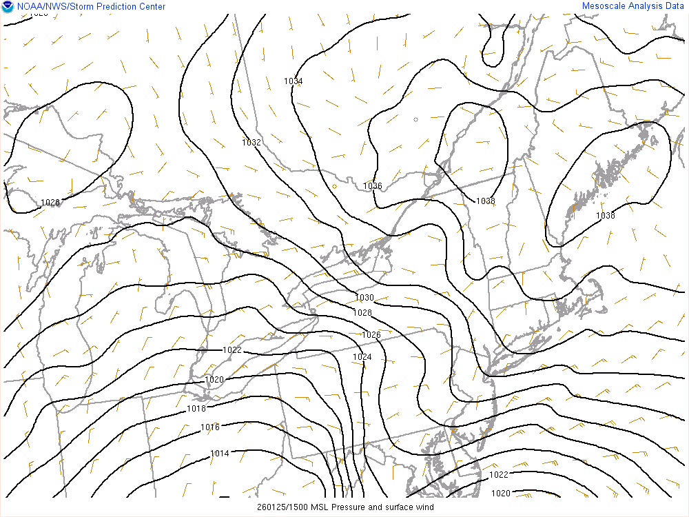
-
Extreme Cold, Snow & Sleet: SECS 1/24 - 1/26
jbenedet replied to TriPol's topic in New York City Metro
Guys gotta pull out the classic cold Damming setups to see how this will play out. The apps really enhance the push and depth of the cold; it will never get resolved by guidance. At a minimum expect the surface freezing line to remain ~25 miles further south/east than progged. That’s your easy bet. -
Those numbers still seem low by you guys given the duration of this. buried.
-
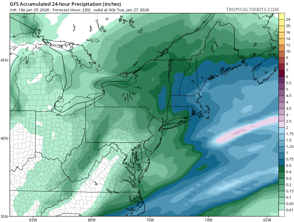
It’s going to be difficult to overestimate the totals around Boston. It snows most of the day tomorrow. 24” is a floor.
-
The big surprise will be the -NAO look that this thing develops late tomorrow morning as it moves inside the benchmark, slowing down and throwing CCB back from north central Jersey to throughout New England. We will all be waking up to a storm in its 6th/7th inning.
-
Extreme Cold, Snow & Sleet: SECS 1/24 - 1/26
jbenedet replied to TriPol's topic in New York City Metro
NYC metro has biggest upside potential. The surface high position/intensity and antecedent is pretty well perfect. It’s one of the rare times to bet against the “warming 925 - 800 into go time” -
Extreme Cold, Snow & Sleet: SECS 1/24 - 1/26
jbenedet replied to TriPol's topic in New York City Metro
I’ve been saying a NYC and Boston jackpots. both have meso enhancements from a stationary coastal front and no mixing… In the case of NYC, it’s on the line of current guidance but I think it sticks with 90%+ snow. That’s a solid endorsement now by the GEFS. -
I think the pre and post storm severe cold is what’s making it a bigger deal than usual around here That’s what’s on my mind anyway.
-
Funny you sent this. I’m headed there in like 15 min to pick up some of my buddy’s favorites.
-
I’d say at this stage put 12” in your head.
-
I could easily see this evolving to include a NYC metro jackpot. Makes sense. So overdue. And with how cold this winter has been it’s the year shit can’t break wrong last minute. You can stack it even more considering the calendar and peak climo.
-
Today’s a great day for a beer and “major snowstorm incoming thoughts”. Man it’s been a while…
-
That’s a good baseline right here. right now I’m thinking BOS is like 24-30” and I’m 12-18” That’s a low confidence game though at this stage, but gun to head guess right now, that’s how I’d roll
-
@40/70 Benchmark The PV block wins. Cheers.
-
NY and Boston gonna get dumped on.
-
Really good look with this storm at this hour and latest trends. I also don’t think the qpf amounts are done moving higher. Watching for a slowing trend…
-
SNE looks like sweet spot for this. I also think NYC comes back with much less mixing…
-
Actually no. If you’ve been paying attention SNE outside the immediate coast has been a sweet spot. Now I think the immediate coast is also in a great spot.
-
This now has the look of a classic DC to Boston MECS. I do think the megalopolis is all in game for 12”+