jbenedet
-
Posts
7,815 -
Joined
-
Last visited
Content Type
Profiles
Blogs
Forums
American Weather
Media Demo
Store
Gallery
Everything posted by jbenedet
-

January 2026 regional war/obs/disco thread
jbenedet replied to Baroclinic Zone's topic in New England
Hopes and dreams. -
January 2026 regional war/obs/disco thread
jbenedet replied to Baroclinic Zone's topic in New England
In terms of lead time I’d normally agree with you. But this is as suppressive a look you can get based on airmass ( without mid level confluence). We are filling in for Canada this weekend.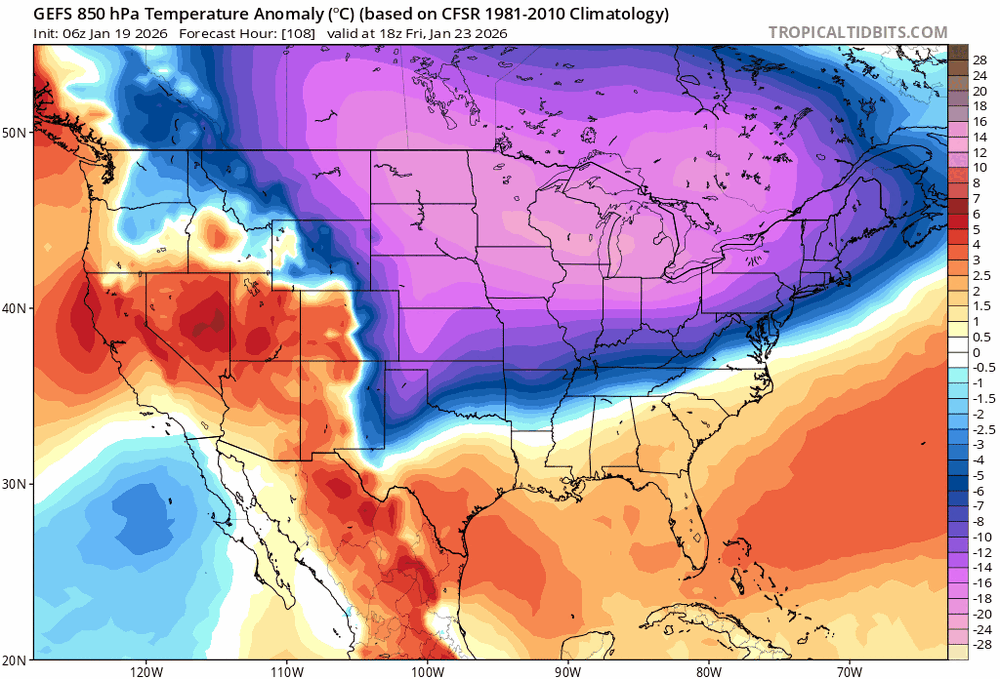
-
January 2026 regional war/obs/disco thread
jbenedet replied to Baroclinic Zone's topic in New England
You don’t take the op runs over the EPS /GEFS at this stage. Inside day 4 you might start weighing them similarly. -
January 2026 regional war/obs/disco thread
jbenedet replied to Baroclinic Zone's topic in New England
North of I80 in PA is out of the game on the weekend threat. -
January 2026 regional war/obs/disco thread
jbenedet replied to Baroclinic Zone's topic in New England
-
January 2026 regional war/obs/disco thread
jbenedet replied to Baroclinic Zone's topic in New England
Yea timed with peak winter climo as well. -
January 2026 regional war/obs/disco thread
jbenedet replied to Baroclinic Zone's topic in New England
Good luck on that…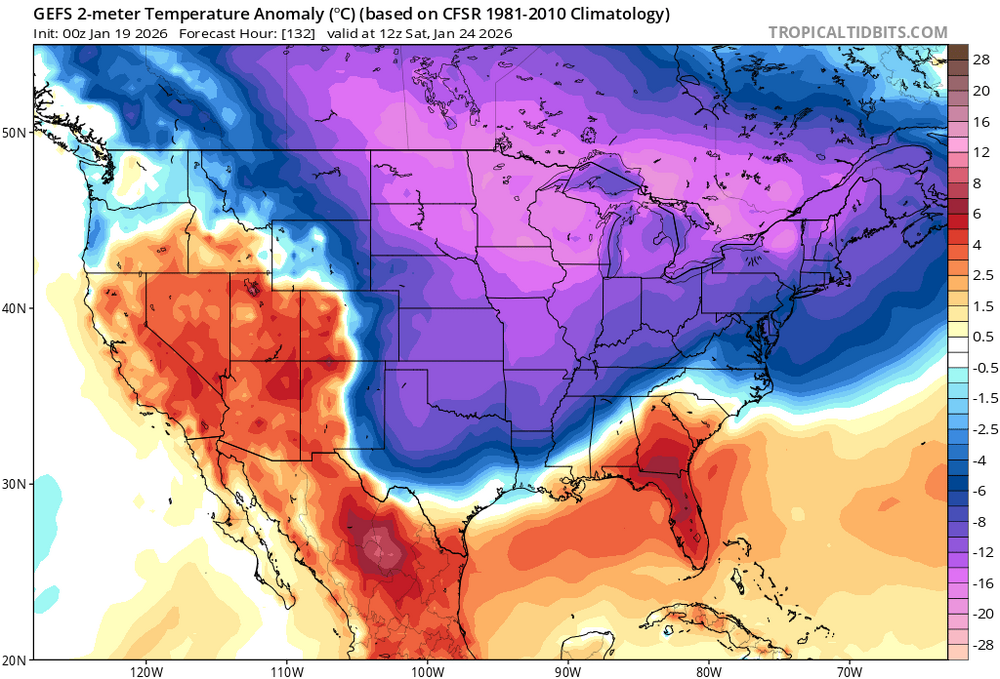
-
January 2026 regional war/obs/disco thread
jbenedet replied to Baroclinic Zone's topic in New England
NNE already with high odds of very cold and very dry after today through month end imo. I’m more inclined to include that region to pike - north than not, at this point. But will give that a few more days of model runs… -
January 2026 regional war/obs/disco thread
jbenedet replied to Baroclinic Zone's topic in New England
Good thing having the snow cover around before that serious freeze next weekend…Oof. Insulate the basement/pipes and protect the plant roots… -
Another Coating of Snow Saturday - "It's all we Got"
jbenedet replied to Sey-Mour Snow's topic in New England
I guess you haven’t been on then. -
Another Coating of Snow Saturday - "It's all we Got"
jbenedet replied to Sey-Mour Snow's topic in New England
Raining here -
First Legit Storm Potential of the Season Upon Us
jbenedet replied to 40/70 Benchmark's topic in New England
Filtered sun and 34 here currently… Interesting… -
First Legit Storm Potential of the Season Upon Us
jbenedet replied to 40/70 Benchmark's topic in New England
I’d call 3-6” -
First Legit Storm Potential of the Season Upon Us
jbenedet replied to 40/70 Benchmark's topic in New England
Yea you want to be south/east with this. The trailing vort is a kicker that inhibits the latitude gain of the CCB.. Eastern LI, southeastern MA -
First Legit Storm Potential of the Season Upon Us
jbenedet replied to 40/70 Benchmark's topic in New England
We had to sacrifice this afternoon batch to get tomorrow to work. speaking for the eastern crew… -
First Legit Storm Potential of the Season Upon Us
jbenedet replied to 40/70 Benchmark's topic in New England
I’m with @dendrite But regardless - AIFS better than Euro/GFS, considering the list.. -
First Legit Storm Potential of the Season Upon Us
jbenedet replied to 40/70 Benchmark's topic in New England
Said differently, it’s like it took the rest of guidance two days to catch up to the EC AIFS… I’m able to say that bc it had the right depiction and stayed on it…. -
First Legit Storm Potential of the Season Upon Us
jbenedet replied to 40/70 Benchmark's topic in New England
Hasn’t the EC AIFS had highest verification scores as of late…? I’m not sure why anyone is doubting it against the other globals. Having that 32F surface isotherm dancing around our heads was a pretty easy tell we could get a good event here despite all the short term model waffling, across the other guidance. The EC AIFS also kicked azz bc look at the past two days of runs—-so consistent.
-
January 2026 regional war/obs/disco thread
jbenedet replied to Baroclinic Zone's topic in New England
Yea buckshot. Exactly. I’m painting with CPC brush here… Which one? — it’s this one… I ain’t picking and choosing runs here either. Pretty much all major guidance has had some variation of this over the last day or two and you can see the signal faintly on the ensembles…
-
January 2026 regional war/obs/disco thread
jbenedet replied to Baroclinic Zone's topic in New England
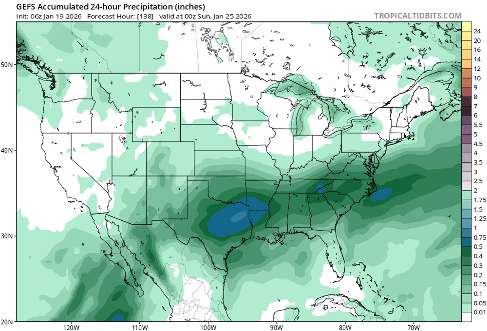
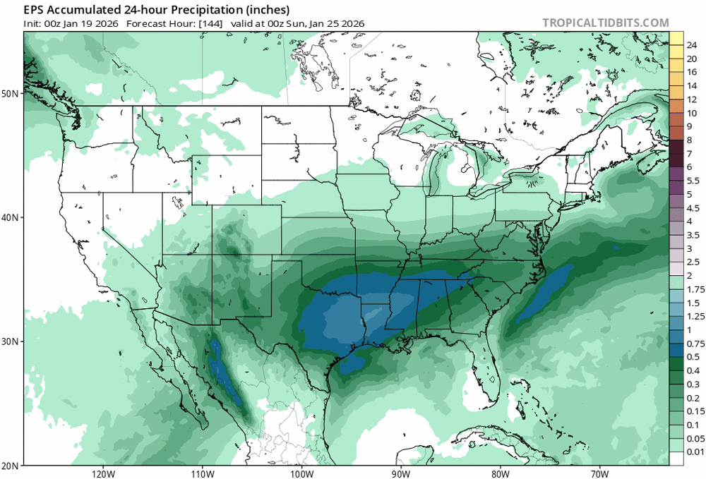
That day 9/10 threat I think that’s big dawg potential for mid Atlantic. Our region can be in on it but I really feel like odds are low north of pike. Best focus around interstate 80. Of course early but that’s my feel for best threat in view right now. -
January 2026 regional war/obs/disco thread
jbenedet replied to Baroclinic Zone's topic in New England
That interstate 80 region from PA to NY looks like a sweet spot, 20th to month end. Good time for you to be watching closely. -
January 2026 regional war/obs/disco thread
jbenedet replied to Baroclinic Zone's topic in New England
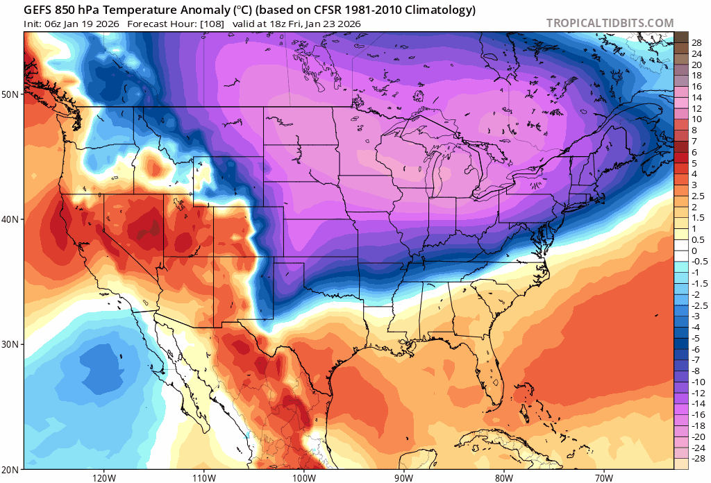
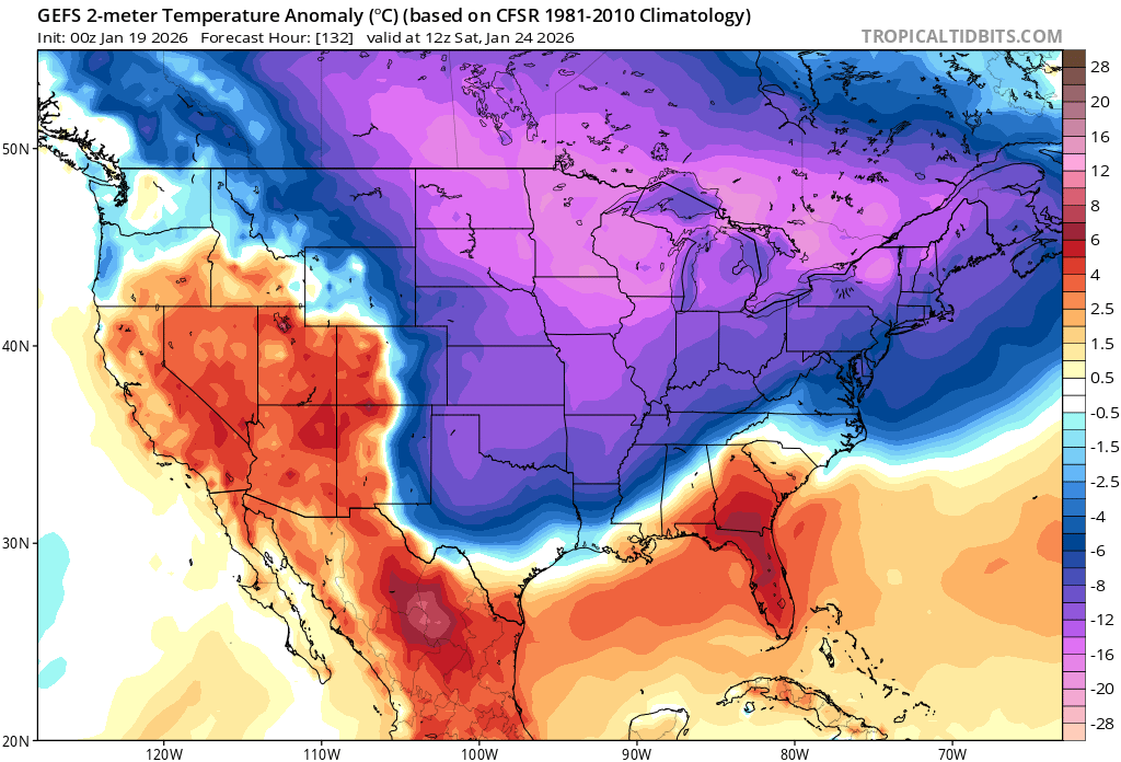
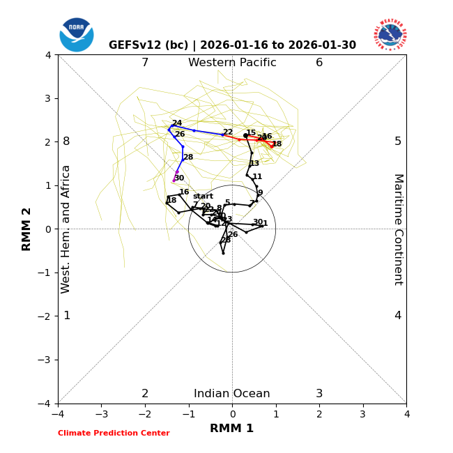
That MJO phase 7 doesn’t look like it’s happening beyond a blip. Synoptically it’s not long enough for the pattern to conform… I think we go back in the freezer and phase 8 and it’s wagons south for the big snows… Colder and Drier with latitude… La Niña and the calendar reigns… Not happy to report but that’s how it looks now. Maybe a great period for heavy snowfall in the most southern sections of the forum. If you’re looking for big snow you want to be in the mid Atlantic during last 10 days of Jan. This is completely different than my three-day-ago thoughts…but oh well. -
The GEFS still in disagreement but looking across guidance it’s likely the one that’s wrong. The bulk of guidance has an MJO phase 8 look to it with significant cold anomalies across NA during the last 10 days of Jan. If that’s the case it looks largely like a repeat of December to first week of Jan pattern for my area…Not a fan…. Cold and dry here… Winter Storm tracks focused on the mid Atlantic. That would also fit the mold of La Niña…
-
January 2026 regional war/obs/disco thread
jbenedet replied to Baroclinic Zone's topic in New England
Regarding northeast — it’s the first time all season we are below last year’s snow coverage and by a lot. -
January 2026 regional war/obs/disco thread
jbenedet replied to Baroclinic Zone's topic in New England
Snow is gone here. Only the piles. And the piles outside of the parking lots will be gone tomorrow.