jbenedet
-
Posts
7,807 -
Joined
-
Last visited
Content Type
Profiles
Blogs
Forums
American Weather
Media Demo
Store
Gallery
Everything posted by jbenedet
-
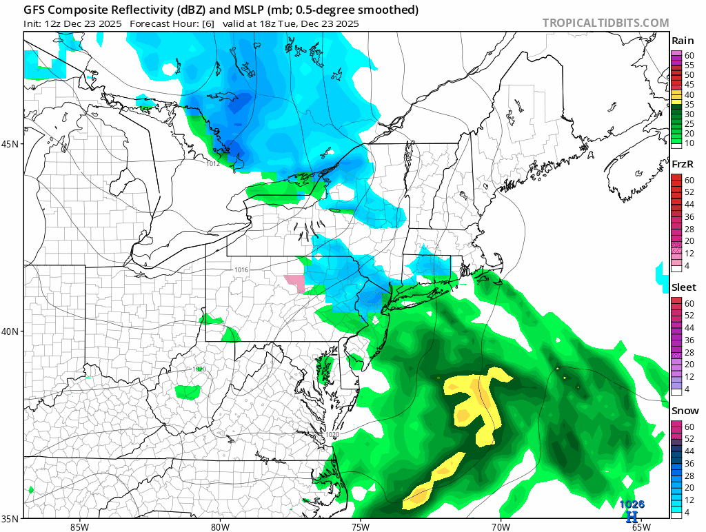
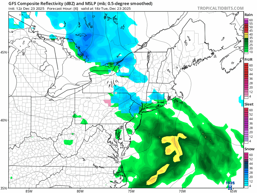
Hope ya’ll checking the progged radar output on the 12z GFS.
-

White Christmas Miracle? December 23-24th
jbenedet replied to Baroclinic Zone's topic in New England
Too low in midcoast Maine to Portland. 6z EPS had 1” qpf. There will be a over a foot locally there. Also think this is too high over here. This map appears as more of an uncertainty cast as to where the band sets up… The band will be about 100 miles wide; go with 2” outside of that and call it a day. -
White Christmas Miracle? December 23-24th
jbenedet replied to Baroclinic Zone's topic in New England
Yea not talking about that. Talking about later… -
White Christmas Miracle? December 23-24th
jbenedet replied to Baroclinic Zone's topic in New England
The shit streak surprise in SNE tells me expect some forcing to be robbed with the part two “lead” of the clippah. -
White Christmas Miracle? December 23-24th
jbenedet replied to Baroclinic Zone's topic in New England
Better off taking the under 10:1 on ratios. I also don’t see how I eek out 0.25” qpf here but all the guidance showing it… On ratios - the risks are not BLtemp related but lift, weak snow growth, and scattered light precip. None of this bodes well to stack. 7:1 probably better hedge… Unless you get into the IVT this should be the story in eastern New England sans Maine and the far interior of NH. -
White Christmas Miracle? December 23-24th
jbenedet replied to Baroclinic Zone's topic in New England
Virga she wrote… Virga sheeeeeee wrote. -
White Christmas Miracle? December 23-24th
jbenedet replied to Baroclinic Zone's topic in New England
This still looks more like a late blooming miller B to me. Two maxes. One in far western sections before the transfer and the second in mid coast- down east Maine, + (maybe the cape). There will be a min in between that transfer as clipper fizzles. Think less norlun, more miller B ish type evolution. -
White Christmas Miracle? December 23-24th
jbenedet replied to Baroclinic Zone's topic in New England
lol “storm”. Yea go run with that to your friends. Tell them about the incoming storm. Moose fart is more like it. -
White Christmas Miracle? December 23-24th
jbenedet replied to Baroclinic Zone's topic in New England
There’s a late blooming miller b type distribution of qpf showing up on the ensemble guidance. That’s likely how this evolves… A local max at points west of CT river, and then points east in Maine with the weak/late redevelopment. Very weak system overall. -
White Christmas Miracle? December 23-24th
jbenedet replied to Baroclinic Zone's topic in New England
The EPS and GEFS are nothing like the ops. All kinds of red flags on the 6z euro with a 1007 mb low near PWM on the 6z EPS and weaker from the prior run. This is a weak low surrounded by surface highs, with no opportunity to amplify with the mid level flow compressing out of southeast Canada. Shrediola. -
Seeing some rich green grass pop through the snow cover has me thinking this early season snowfall did a lot of good to help my young lawn establish further before being really stressed.
-
This storm just kept steadily intensifying on all guidance over time. Now seeing 969 mb, on the euro, about 200 miles north of Quebec City.
-
Agreed. But usually if there’s a refreeze the morning before temp/td spike you can get some resistance out of the pack. No chance if it’s been thawing for 24+ hours, as will be in this case.
-
Guidance was too low for the morning temps up here. Even DAW stayed comfortably above freezing all night.
-
Real killer to the pack is 32+ dews though and that happened before midnight and kept slowly rising all morning.
-
Today’s progged highs will easily be exceeded. Upper 40’s in view for many.
-
There’s a lot of support for that look. La Nina (Jan), the EPS and GEFS forecasts for the NAO teleconnection are also aligned for deeply negative. The op runs signaling similar. Start worrying.
-
It matches the teleconnection forecast. Not good.
-
Yea this is kinda where I’m at, especially with peak winter climo a few weeks away. NYC metro close enough to watch with keen interest…
-
The cutter will wipe anywhere that doesn’t fall below freezing tonight. Probably the usual line cutting through DAW and N ORH to just north of PWM…
-
This isn’t what we want for the bulk of New England. Seasonal cold and dry, especially in northern New England. Once this -NAO gets entrenched it could even result in N, to AN in Northern and eastern sections of New England. In a La Niña this is something we should be vigilante against as tendency into January is dry up here. The main takeaway is this will send most storm tracks south. I’d be watching intently in mid Atlantic, down to Virginia.
-
Euro with 978 mb in southern Ottawa. 61 is record high for the date here. They will be under threat regionally Should be taking notes that all of our big storms have been cutters. From someone who only wants big snowstorms, and seasonal cold. This is pattern is trash.
-
December 14th - Snow showers or Plowable snow?
jbenedet replied to Sey-Mour Snow's topic in New England
Bc it will be gone by Thursday, and the SNE region up to seacoast NH, Boston and Portland will be tracking less than half climate average snowfall through Christmas. But sure “optimism”. Snow colored glasses and chest pounding from 40/70 too. Good luck with the blogspot. It’s been so bad that 4” gets the attention of DCer’s around here. -
That looks like heavy snow in western queens/nassau right now. ~35 dBz Congrats. Don’t think any major metros up to Portland Maine have seen that this season.
-
Moderate snowfall 12/14/2025 WWA up for most of the area
jbenedet replied to WeatherGeek2025's topic in New York City Metro
It’s a narrow band of frontogenesis. Sinking/subsidence just to the north. Another way to put it is the stronger the band, the worse the subsidence in areas just north of it. Have and have nots right across the sound. Not an exact forecast here but from a conceptual standpoint it’s a case where commack LI could see 6” and north haven CT, 1.5”. The modeling likely underdone on the gradient (delta).