

jbenedet
-
Posts
7,807 -
Joined
-
Last visited
Content Type
Profiles
Blogs
Forums
American Weather
Media Demo
Store
Gallery
Everything posted by jbenedet
-
How things have changed…
-
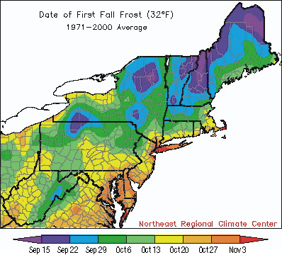
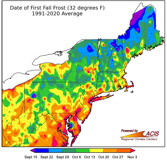
So that was an arctic airmass and basically ideal radiating conditions. If you didn’t get to frost it’s not in your climo anymore for the date…
-
People talking about end of growing season, while I just picked up last round of reseed and fertilizer.
-
We can take the over all the time except…in this pattern.
-
GWDLT That sucks. Way too early.
-
Now today is effin’ dry. Full sun, breezy and dews in low 40’s. caved and watered.
-
Yes agreed on the rain difference vs your area. That said, I’m looking at landscapes relative to the drought monitor conditions… In my experience the seacoast doesn’t radiate well, especially right in the cities, which is where I’m at. Our higher dews than the interior may have made this affect more impactful on the local landscapes. Again, a walk around town, it doesn’t look like severe drought. The drought conditions are hardly noticeable in most cases until, of course, you get to a river..Different world.
-
It has minimal to do with measured precip. Absorption through the leaves is the driving factor. With the near ideal radiational cooling, have had consistent 10-12 hours of dew. It is not a replacement for rain but it definitely has halted drought effects on most shrubs, flowers and grasses locally.
-
Never had this many days of significant radiational cooling in a row since I’ve moved here in 2015. The conditions have also been so suitable to radiate that we hit the dewpoint before midnight and continue slowly dropping to sunrise. Overnight radiational fog has been a regularity right at the surface. It’s a common desert phenomenon that sustains vegetation; it’s doing wonders for my young grass and grass seed. The vegetation around here generally doesn’t reflect the severe lack of rain thanks to this; it looks more mild to moderate…
-
The persistent radiational Dewling has been an important crutch for the dryness. Not a replacement but definitely mitigating the effect of drought conditions on the landscapes here.
-
The 12z NAM just jacked up totals. Now a stripe of 2” through CNE to SE NH
-
Sun breaking out here.
-
The Euro AI, EPS and GEFS are also showing significant rain potential for Wednesday. Favors southern/eastern sections. Looks subtropical.
-

2025 Lawns & Gardens Thread. Making Lawns Great Again
jbenedet replied to Damage In Tolland's topic in New England
I had some really good success with what I put down two weeks ago. But you’re right, I may reseed today the areas I reseeded already that are coming in a little sparse. -
GFS finally caved. Nice region wide soaker incoming.
-
Guidance has juiced up for a region wide 1”+ potential this weekend.
-
Eh. The question moreso is why the qpf output on the GFS is so paltry. Everything else on the same run/model points to a good soaking. GFS is selling well on another bone dry day today but dews really spike throughout the day tomorrow into Saturday. Your bias will change probably when the swamp azz returns…
-
Looks wetter, starting Friday into much of next week. Also appears Lorena in the Eastern pacific will give us an opportunity for tropical remnants middle of next week. I’m thinking for my back yard - just need to make it through next three days with watering and the worst is far behind.
-
Downsloped to mid 70’s. Zero complaints. Beautiful. Will be near 80 today.
-
It’s a very low bar but with this line coming through in 30 min should finish as the wettest day of the summer so far.
-
No severe but a great drink. Wettest week in a month confirmed. Grass looking its best since early may
-
I’m getting ready for severe. Those cells popping in ASH area are strengthening and are immediately preceded by a period of limited clouds, during peak ISR. Primed.
-
I’d start packing seeing that. Wayy too early for my mindset.
-
2025 Lawns & Gardens Thread. Making Lawns Great Again
jbenedet replied to Damage In Tolland's topic in New England
The grass seed I put down less than a week ago already coming up. Much better results than my spring seeding so far… -
If I score measurable precip today and with the rain coming Friday, this week will be the wettest in a month. Maybe longer. To be sure, it’s not much at all - talking less than 0.75” in aggregate —but that’s how dry it’s been… Definitely changes too in terms of cloud cover. Much less full sun, even on the fair weather days.


