jbenedet
-
Posts
7,807 -
Joined
-
Last visited
Content Type
Profiles
Blogs
Forums
American Weather
Media Demo
Store
Gallery
Everything posted by jbenedet
-

Moderate snowfall 12/14/2025 WWA up for most of the area
jbenedet replied to WeatherGeek2025's topic in New York City Metro
I would NOT be using this rationale to go lower. They will lose on that. Looks good for 99% snow. -
It’s beginning to look at lot like torchmas…everywhere you gooooo
-
December 14th - Snow showers or Plowable snow?
jbenedet replied to Sey-Mour Snow's topic in New England
Can’t wait to head to Sey’Mours with my leaf blower Clear his 1” —-days and days of brown. -
Good luck.
-
CAD without a cold airmass is…. Relatively warm northeast flow. Welcome to life away from your computer.
-
The -NAO look some are desperately banking on is also completely absent cold air in southeast Canada. It’s all in the west. And easterly flow is off >45F SST’s. It’s a complete losers bet to expect N to BN during that window. You’ll avoid a torch but still yield +5
-
It’s worth recognizing… You’re a fool.. Even with the coldest Ensemble runs of the EPS for that date, it’s still warm. A loser taking a losing bet. Shocker. That incredible warmth is 250 miles away; the deep cold is 2500 miles away…Take your bet… Some critical thinking is worth something.

-
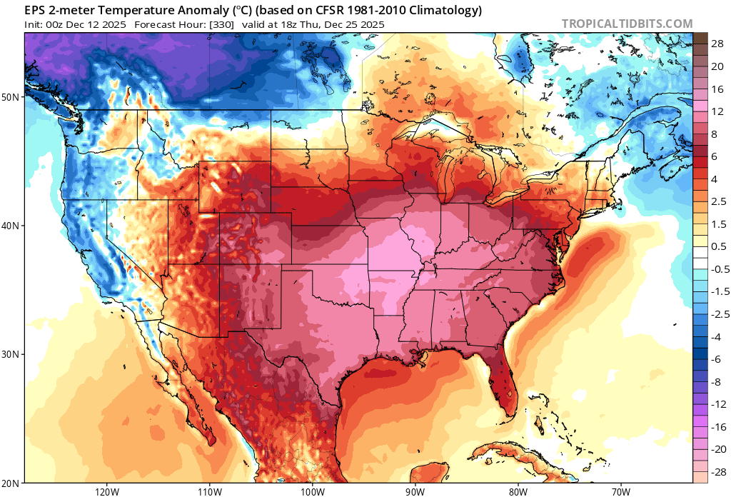
See more snow…than anything I’ve seen observationally or guidance wise. Everything indicating negligible chance of a white christmas near you. Plan for brown, sey-mour. 1” snow chance on 12/14 followed by a week’s worth of cutter threats. As if that wasn’t enough, the 24th/25th continue to look the warmest on the ensemble guidance…
-
I’m convinced you guys don’t go outside at all and look at the world around you. Sad. “Meteorologists”— just model junkies tied to computers with no bearing of observations.
-
No it’s more than that. Past three day we’re running like 5F-7F colder. As I said, there’s been a very significant seasonal gradient persistent for more than just one storm/pack. Highs past three days: PSM: 23, 34, 36 Islip NY: 36, 45, 46
-
Pretty remarkable differences in look and feel from PSM down to eastern LI. snow blowers and ice melt vs green grass and leaf blowers. Traveling 150 miles looks and feels more like 600. It’s November to the south, early January to the north. For my location, it means winter’s grip, currently, isn’t that strong at all—warm sectors will not be strongly defended against… The referenced map is more than just what the last storm brought. There’s a completely different seasonal vibe north/south of that line.
-
I agree in the far interior. Especially NNE. Warming from climo norms is actually conducive to more snowfall. We’ve seen it recently. Dry is the bigger enemy up there. But I do think in large chunk of SNE/CNE up along coastal NNE this is an important trend.
-
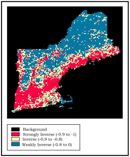
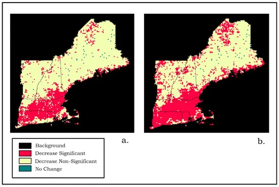
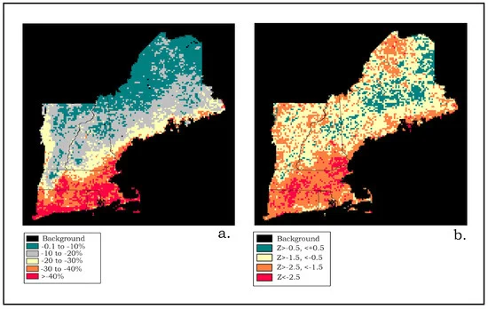
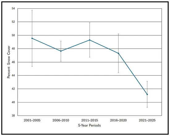
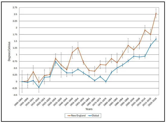
Mods could move this where it needs to go, but this read was extremely informative for our region regarding CC. Another analysis indicating New England is fastest warming region, right along side the arctic. It also corroborates the observations we’ve had that this warming is accelerating. https://www.mdpi.com/2225-1154/13/12/246


-
This weather is the worst. It’s the inverse of 110 heat index. Then the only great place to be is a pool…. Now the only great place to be a is a fireplace. Extremely limiting on daily activities. Even well maintained things, break or fail… If you like this weather you should move to where the cost of living is sooooo much cheaper than New England.
-
This is a fantastic read on CC if you live in the New England area. https://www.mdpi.com/2225-1154/13/12/246
-
First Winter Storm to kickoff 2025-26 Winter season
jbenedet replied to Baroclinic Zone's topic in New England
The ARW’s are very warm as well. I understand them overall biased cold so I find that interesting. -
First Winter Storm to kickoff 2025-26 Winter season
jbenedet replied to Baroclinic Zone's topic in New England
The Great Bay being some 10 miles inland is an important factor that I think only the locals can fully appreciate. -
First Winter Storm to kickoff 2025-26 Winter season
jbenedet replied to Baroclinic Zone's topic in New England
The mesos have been flagging ptype issues off an on for a while along the coast. Now the euro saying the same. FV3 hi-res also been very warm. -
First Winter Storm to kickoff 2025-26 Winter season
jbenedet replied to Baroclinic Zone's topic in New England
The daytime onset is just a very marginal factor negatively affecting an already very marginal snow setup. It would be more credible to stack a warm ground 50F SST’s and the daytime onset for reasons against going higher. -
First Winter Storm to kickoff 2025-26 Winter season
jbenedet replied to Baroclinic Zone's topic in New England
When people lump my climo in with DAW…while I’m 8 miles southeast… and 200 ft lower in elevation. Just shake my head. This is like the 20th time in 10 years that the coastal front will be right over my head. -
November 2025 general discussions and probable topic derailings ...
jbenedet replied to Typhoon Tip's topic in New England
The first week of December is warming on guidance. MJO, teleconnections forecasts are all moving to warm phases. I don’t get the excitement at all. MJO phase 7 in November is actually N to cold but we are moving into December as we settle into that phase. I think this is leading to some false cold signals on guidance. Of course I’m speaking wrt where most of us live—close to the coast. The modeling showing more ridging in the SE and cold dumping over the central CONUS is much more in line with the tapestry of MJO phase 7 in December. -
November 2025 general discussions and probable topic derailings ...
jbenedet replied to Typhoon Tip's topic in New England
Not the best harbinger for winter weenies https://www.wmur.com/article/rare-bird-sighting-portsmouth-nh-11232025/69522743 “The species typically breeds in Europe and winters in tropical Africa. This is the first recorded sighting in New Hampshire.” -
November 2025 general discussions and probable topic derailings ...
jbenedet replied to Typhoon Tip's topic in New England
Day after thanksgiving —behind the front—it will be colder in Asheville NC than seacoast NH. Another case when the core of the cold dumps south and west. In other news, that’s like the 10th run in a row on the op GFS, developing a TC south of Jamaica around day 7… -
November 2025 general discussions and probable topic derailings ...
jbenedet replied to Typhoon Tip's topic in New England
That U-shape to climate change over North America should be engrained in your brain… where Bangor Maine is +4 while DFW is less than +1 over the same time frame. This of course follows the behavior of the jet. The cold has increasing propensity to dump over the central US, but warmer SST’s especially with latitude is generating more inland runners. Shortwaves are finding less suppression as they travel east. No surprises here. The observational snowfall in the northeast has also followed with significant winters in Vermont and Upstate NY and the far interiors of NH and Maine. There will be exceptions of course, but this is new key persistence to factor into your seasonal forecasts, especially when this tendency is showing itself in real time, as it is now. -
November 2025 general discussions and probable topic derailings ...
jbenedet replied to Typhoon Tip's topic in New England
Dews on the Euro are showing mid 50’s. Airmass is cooked. 60’s are game but 70 is still a reach. Will have to watch bc it’s a torch setup. Question is can we maximize based on timing and clouds.