kat5hurricane
-
Posts
923 -
Joined
-
Last visited
Content Type
Profiles
Blogs
Forums
American Weather
Media Demo
Store
Gallery
Everything posted by kat5hurricane
-
Extreme Cold, Snow & Sleet: SECS 1/24 - 1/26
kat5hurricane replied to TriPol's topic in New York City Metro
That's very bullish. It seems like Mt. Holly and Upton are going more aggressive in the past decade or so compared to their usual conservative nature. It's possible I suppose but 13-14+ areawide seems like a longshot IMO -
Extreme Cold, Snow & Sleet: SECS 1/24 - 1/26
kat5hurricane replied to TriPol's topic in New York City Metro
When the GFS is on its own I'd just about discount it. It will likely fall in line with other guidance at the last minute like it usually does -
Extreme Cold, Snow & Sleet: SECS 1/24 - 1/26
kat5hurricane replied to TriPol's topic in New York City Metro
I find that thumps in SWFEs tend to underachieve a bit and mix quicker than modeled. I think the higher ceiling depends on if the costal gets going but otherwise looks like a 6-8" to sleet type of deal for coastal areas. Those in Rockland and further NW look to be in a great spot for major snows but 6-8" would be the biggest storm in years for coastal areas so we'll certainly take that. -
Extreme Cold, Snow & Sleet: SECS 1/24 - 1/26
kat5hurricane replied to TriPol's topic in New York City Metro
This is why it's hard to get too excited about SWFEs. The trend seems to be warming of the mid levels and bringing in more mixing as is usually the case in these situations. I bet that the GFS starts moving off the colder solutions soon. Looks like a solid storm regardless, just maybe not a major outside of the suburbs. -
Extreme Cold, Snow & Sleet: SECS 1/24 - 1/26
kat5hurricane replied to TriPol's topic in New York City Metro
I'm looking at trends. Outside of the flatter GFS which is a garbage model lets be honest and a follower more than a leader, most other models are starting to introduce a warm layer that cuts down on totals somewhat and this might not be done trending, that SE Ridge often times plays a factor. Regardless, the floor looks to be a significant snow before any changeover so it's not a bad place to be. -
Extreme Cold, Snow & Sleet: SECS 1/24 - 1/26
kat5hurricane replied to TriPol's topic in New York City Metro
It's looking more like a SWFE with a heavy thump to ice mess as opposed to the cold long duration storm it looked like a few days ago but 6-8"+ is nothing to sneeze at especially after recent winters. My concern is that these things tend to trend north and we can't afford many more trends north close to the city at least, I think everybody NW of the city are sitting pretty now. -
Extreme Cold, Snow & Sleet: SECS 1/24 - 1/26
kat5hurricane replied to TriPol's topic in New York City Metro
I'm not making any judgments about trends until the 0z suite. The 18z runs almost always have wonky solutions. -
Extreme Cold, Snow & Sleet: SECS 1/24 - 1/26
kat5hurricane replied to TriPol's topic in New York City Metro
I don't see any models showing mixing issues until the main show is over so I don't agree that it's a big concern now but we need the primary low to stop trending north now, there's less wiggle room than there was 24 hours ago. Sometimes models (the windshield wiper effect) overcorrect in one direction then move back the other way before the final solution so I wouldn't be surprised if we saw some flatter solutions at 0z. Still a lot of solutions on the table. -
Extreme Cold, Snow & Sleet: SECS 1/24 - 1/26
kat5hurricane replied to TriPol's topic in New York City Metro
PDII was kind of like this but a little less coverage than the models are currently printing out. These long duration storms are my favorite, nice cold storm with steady 1"/hr rates for many hours. -
Extreme Cold, Snow & Sleet: SECS 1/24 - 1/26
kat5hurricane replied to TriPol's topic in New York City Metro
There's a pretty high floor with this system because it's so large with tons of moisture and very cold air but the question is the phasing which would create a much higher ceiling. This doesn't feel like a thread the needle situation that we usually see in these parts with an all or nothing scenario. -
Extreme Cold, Snow & Sleet: SECS 1/24 - 1/26
kat5hurricane replied to TriPol's topic in New York City Metro
PDII was a two part system but, yes, it's rare to get a two part wallop at the coast especially -
Extreme Cold, Snow & Sleet: SECS 1/24 - 1/26
kat5hurricane replied to TriPol's topic in New York City Metro
February 2010 was one of the most painful times for me as a snow lover. This one is giving me those vibes unfortunately but plenty of time left for changes obviously. -
That's what gives me a bit more confidence. These large sprawling long duration events are generally more accurately modelled than the thread the needle faster moving ones. As of now, it's just nice to have something to track.
-
Give us this look in 2-3 days and I'll get excited but when you see a model consensus on a big storm in the vicinity even if it's still almost a week out it definitely deserves attention.
-
I'm very concerned about suppression, that's some serious cold pressing down this weekend. As is the case most of the time with these patterns, the best chance for a big storm is when the pattern relaxes a bit but at least we have some tracking to do in the meantime which is a god send after 3-4 winters of not even mere tracking.
-
Storm potential January 17th-18th
kat5hurricane replied to WeatherGeek2025's topic in New York City Metro
Radar looks pretty good to me. Steady light snow now sticking everywhere, looks nice and wintry. -
Storm potential January 17th-18th
kat5hurricane replied to WeatherGeek2025's topic in New York City Metro
Good tip, I just tried that and you're right. I actually do most of my Americanwx browsing on my phone but I usually look at it vertically except when I'm watching videos. As an aside, snow finally starting to stick in Whitestone now that the rates are picking up a bit. -
Storm potential January 17th-18th
kat5hurricane replied to WeatherGeek2025's topic in New York City Metro
Oh that's right, good point. I didn't take that into account -
Storm potential January 17th-18th
kat5hurricane replied to WeatherGeek2025's topic in New York City Metro
It's right there in my location, right to the left of this post haha. Whitestone -
Storm potential January 17th-18th
kat5hurricane replied to WeatherGeek2025's topic in New York City Metro
Nothing but white rain thus far -
Storm potential January 17th-18th
kat5hurricane replied to WeatherGeek2025's topic in New York City Metro
That's exactly what I said lol -
Storm potential January 17th-18th
kat5hurricane replied to WeatherGeek2025's topic in New York City Metro
I didn't expect it to accumulate on all surfaces so quickly but that's what heavier rates will do for you especially in January. -
Storm potential January 17th-18th
kat5hurricane replied to WeatherGeek2025's topic in New York City Metro
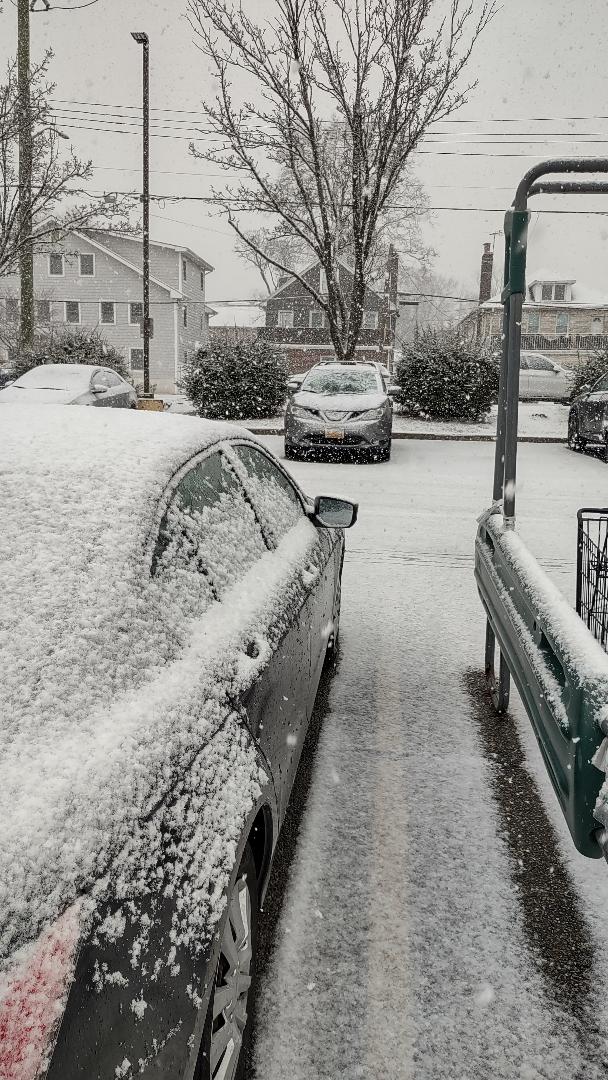
I did not expect this, I went into the store with just wet ground and a few flurries and a half an hour later... This was about a half hour ago, it's approaching about 2" now. Very nice surprise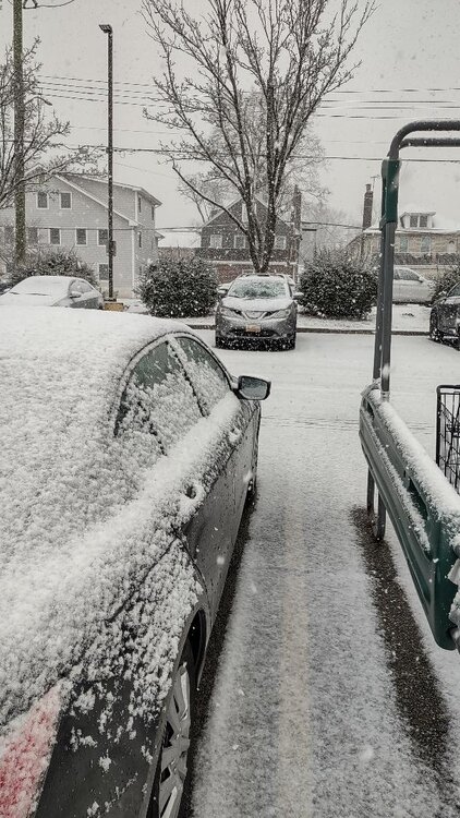
-
I may have jumped the gun. Just went out there and it's about 3" and the heaviest of the night is coming down now and piling up quickly, hoping to get 4-5 out of it.
-
It looks nice outside but it's definitely on the low end of the 4-8" predictions, lower than that actually. We had 1-2 hours of moderate snow and that's about it. We'll see how the rest of the night plays out but it's been a pretty lame storm overall.