jjwxman
-
Posts
343 -
Joined
-
Last visited
Content Type
Profiles
Blogs
Forums
American Weather
Media Demo
Store
Gallery
Everything posted by jjwxman
-
FWIW… the Extended run of the 00z HRRR takes Ian even further into the Atlantic through hr48. .
-
That’s a heck of a shift East on the 18z EPS… Wow! 12z vs 18z EPS .
-
The 00z CMC also shows the stall over Florida and then north into the SE US. .
-
January 20-22 “bring the mojo” winter storm threat
jjwxman replied to lilj4425's topic in Southeastern States
The resemblance on the 00z NAM vs the 00z RGEM is insane. Kuchera maps [emoji3596] . -
4:25 am. 30/6 in Randleman, NC. Man this has 12/4/2002 vibes. Ugh. .
-
Winter Storm Izzy Obs Thread
jjwxman replied to Prismshine Productions's topic in Southeastern States
4:00 am. 30/8 in Randleman, NC Chapstick dry. Evaporative cooling should begin soon. Hopefully the dynamical cooling can keep the 850 just sub freezing long enough to get an inch or two. . -
The 00z Euro holds course. .
-
NWS Raleigh is calling for 0.20”-0.40” with isolated areas approaching 0.50” in their latest WSW statement for the Triad. I’m prepared to be without power for several days. .
-
I was 17 when that storm hit. I remember the sky lighting up everywhere bc all the transformers blowing and the sound of falling trees is something I’ll never forget. They had to replace about every single power pole on our 5 mile street. We were without power for 12 days I believe. Now a father of young children myself I’m not looking forward to this storm. We’re pretty much in the bullseye for freezing rain in Northern Randolph County. .
-
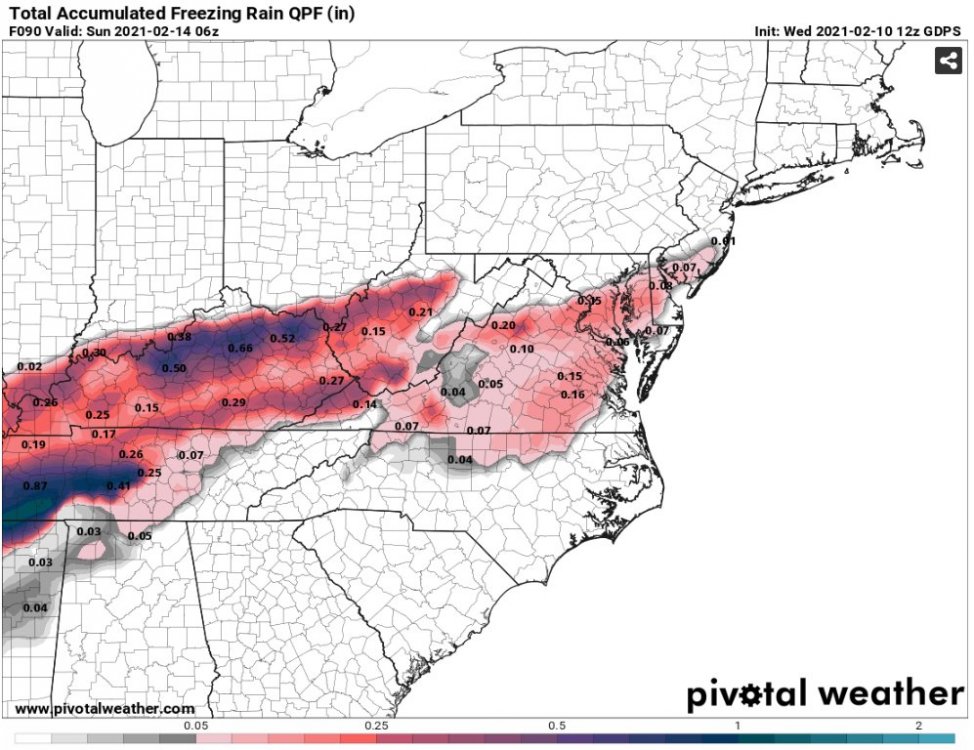
FWIW: 00z FV3 Hi Res as the storm moves in. I haven’t looked at this model all that much. Is it supposed to take the place of the Hi Res NAM eventually? .
-
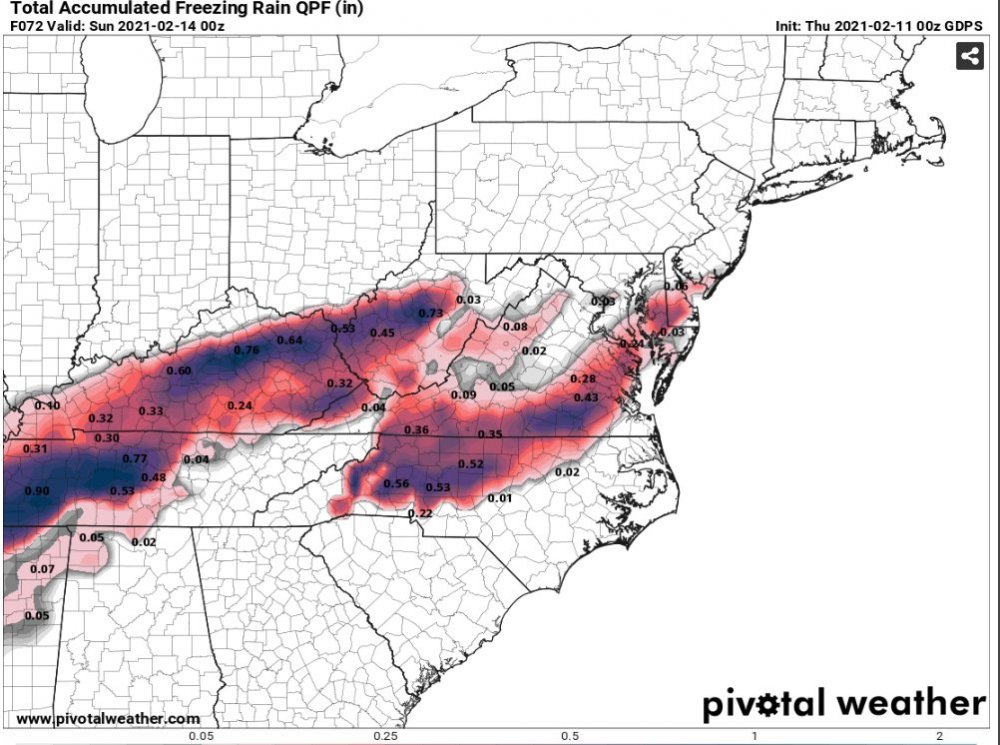
Taken verbatim the I-85 corridor would be in for potentially another ice storm depending on what this weekend’s system does. .
-
Geez… the Triad went from 1-2ft of snow to a crippling ice storm in 24 hours via the GFS. What’s next? Tornado outbreak by the 00z run Thursday? [emoji3061] What can you say, it’s Winter in the SE. .
-
FWIW The 00z GEFS cut the mean snowfall from the 18z run in half. But it is colder at the surface. It’s definitely not seeing the up the coast solution like the Op. .
-
Wow, the 00z GFS was a run for the ages. Well Over a foot of snow in the from CLT to the Triad and the Triangle. Add to that very strong winds, with surface temps in the 20’s for a big portion of NC. That’s a legit blizzard from the GFS. Also a nasty ice storm along the Hwy 1 corridor. Just incredible. If the Euro spits out something even half that we’ll see everyone jump on board tomorrow. .
-
Sizable shift south on the HRRR, NAM’s. Combination of confluence over the Midwest and less amped? Interesting. .
-
Agreed. RAH hasn’t mentioned anything frozen in their HWO for the Triad area. I’m sure they will with Sunday morning’s update. I’ve come to respect their seemingly conservative approach. It has served them well more times than not. .
-
2021-2022 Fall/Winter Mountains Thread
jjwxman replied to BlueRidgeFolklore's topic in Southeastern States
Yeah the whole cold air chasing moisture is a losers bet. But this one is sneaky. If there is a wild card in all of this it will be the track and how fast the LP deepens or strengthens as it moves off the coast. The associated dynamics may aid in rapidly cooling the entire column before all the moisture moves out. As always in NC timing is everything. . -
NAM’d…. [emoji102] .
-
Me every time I walk past my weather station and continue see 43 degrees. Lol.

-
February 18-19 MAJOR Ice Storm Threat
jjwxman replied to NorthHillsWx's topic in Southeastern States
42/28 fifteen miles south of GSO. -
February 18-19 MAJOR Ice Storm Threat
jjwxman replied to NorthHillsWx's topic in Southeastern States
Well it’s RAH after all, they have always played it conservative, and It has a served them well more times than not. -
February 18-19 MAJOR Ice Storm Threat
jjwxman replied to NorthHillsWx's topic in Southeastern States
Sitting here in Northern Randolph wondering the same. I will say the last ice event this past weekend we just got a light glaze. No two events are alike, however Climatology says there’s generally a tight cutoff just south and east of the I-85 corridor on events like these. I suspect that Davidson and Randolph will be placed under a warning if data holds/keeps trending over night. -
February 18-19 MAJOR Ice Storm Threat
jjwxman replied to NorthHillsWx's topic in Southeastern States
RAH is sounding the alarm. WSW now in place for their farthest NW counties including the Triad and Roxboro. WINTER STORM WATCH IN EFFECT FROM LATE WEDNESDAY NIGHT THROUGH THURSDAY EVENING... * WHAT...Significant icing possible. Total ice accumulations of at least one quarter of an inch possible. * WHERE...Person, Forsyth and Guilford Counties. * WHEN...From late Wednesday night through Thursday evening. * IMPACTS...Power outages and tree damage are likely due to the ice. Travel could be nearly impossible. The hazardous conditions could impact the morning or evening commute. -
That boundary on the NAM...
-
Wow... The 00z CMC really increases the icing threat on Saturday compared to the 12z run.